
KNOWPIA
WELCOME TO KNOWPIA

Muchedent 
Summary
Muchedent (French pronunciation: [myʃdɑ̃]) is a commune in the Seine-Maritime department in the Normandy region in north-western France.
Muchedent | |
|---|---|
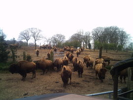 The bison farm | |
Location of Muchedent .mw-parser-output .locmap .od{position:absolute}.mw-parser-output .locmap .id{position:absolute;line-height:0}.mw-parser-output .locmap .l0{font-size:0;position:absolute}.mw-parser-output .locmap .pv{line-height:110%;position:absolute;text-align:center}.mw-parser-output .locmap .pl{line-height:110%;position:absolute;top:-0.75em;text-align:right}.mw-parser-output .locmap .pr{line-height:110%;position:absolute;top:-0.75em;text-align:left}.mw-parser-output .locmap .pv>div{display:inline;padding:1px}.mw-parser-output .locmap .pl>div{display:inline;padding:1px;float:right}.mw-parser-output .locmap .pr>div{display:inline;padding:1px;float:left}html.skin-theme-clientpref-night .mw-parser-output .od,html.skin-theme-clientpref-night .mw-parser-output .od .pv>div,html.skin-theme-clientpref-night .mw-parser-output .od .pl>div,html.skin-theme-clientpref-night .mw-parser-output .od .pr>div{background:#000;color:#fff}html.skin-theme-clientpref-night .mw-parser-output .locmap{filter:grayscale(0.6)}@media(prefers-color-scheme:dark){html.skin-theme-clientpref-os .mw-parser-output .locmap{filter:grayscale(0.6)}html.skin-theme-clientpref-os .mw-parser-output .od,html.skin-theme-clientpref-os .mw-parser-output .od .pv>div,html.skin-theme-clientpref-os .mw-parser-output .od .pl>div,html.skin-theme-clientpref-os .mw-parser-output .od .pr>div{background:#000;color:#fff}}  Muchedent  Muchedent | |
| Coordinates: 49°46′21″N 1°10′59″E / 49.7725°N 1.1831°E | |
| Country | France |
| Region | Normandy |
| Department | Seine-Maritime |
| Arrondissement | Dieppe |
| Canton | Luneray |
| Intercommunality | CC Terroir de Caux |
| Government | |
| • Mayor (2020–2026) | Christine Cressent[1] |
| Area 1 | 7.05 km2 (2.72 sq mi) |
| Population (2021)[2] | 128 |
| • Density | 18/km2 (47/sq mi) |
| Time zone | UTC+01:00 (CET) |
| • Summer (DST) | UTC+02:00 (CEST) |
| INSEE/Postal code | 76458 /76590 |
| Elevation | 43–176 m (141–577 ft) (avg. 60 m or 200 ft) |
| 1 French Land Register data, which excludes lakes, ponds, glaciers > 1 km2 (0.386 sq mi or 247 acres) and river estuaries. | |
Geography edit
A small farming village situated by the banks of the river Varenne in the Pays de Caux, some 13 miles (21 km) south of Dieppe at the junction of the D77, the D154 and the D476 roads.
Population edit
| Year | Pop. | ±% p.a. |
|---|---|---|
| 1968 | 112 | — |
| 1975 | 115 | +0.38% |
| 1982 | 96 | −2.55% |
| 1990 | 117 | +2.50% |
| 1999 | 129 | +1.09% |
| 2007 | 118 | −1.11% |
| 2012 | 139 | +3.33% |
| 2017 | 131 | −1.18% |
| Source: INSEE[3] | ||
Places of interest edit
See also edit
References edit
- ^ "Répertoire national des élus: les maires" (in French). data.gouv.fr, Plateforme ouverte des données publiques françaises. 13 September 2022.
- ^ "Populations légales 2021". The National Institute of Statistics and Economic Studies. 28 December 2023.
- ^ Population en historique depuis 1968, INSEE
External links edit
Wikimedia Commons has media related to Muchedent.
- Website of the bison farm (in French)