


Summary
Mukhalingam, also known as Srimukhalingam or Mukhalinga, is a village panchayat in Jalumuru mandal of Srikakulam district in the Indian state of Andhra Pradesh. Historically known as Kalinganagari, Mukhalingam served as the capital of Eastern Ganga Dynasty from 6th century AD to 12th century AD. Emperor Sri Ananthavarma Chodaganga Devara conquered Utkala in 1122 AD and shifted the capital from Kalinganagari to Caudwara kataka[2]
Mukhalingam
Srimukhalingam | |
|---|---|
Village | |
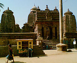 Srimukhalingam temple | |
Dynamic map.mw-parser-output .locmap .od{position:absolute}.mw-parser-output .locmap .id{position:absolute;line-height:0}.mw-parser-output .locmap .l0{font-size:0;position:absolute}.mw-parser-output .locmap .pv{line-height:110%;position:absolute;text-align:center}.mw-parser-output .locmap .pl{line-height:110%;position:absolute;top:-0.75em;text-align:right}.mw-parser-output .locmap .pr{line-height:110%;position:absolute;top:-0.75em;text-align:left}.mw-parser-output .locmap .pv>div{display:inline;padding:1px}.mw-parser-output .locmap .pl>div{display:inline;padding:1px;float:right}.mw-parser-output .locmap .pr>div{display:inline;padding:1px;float:left}html.skin-theme-clientpref-night .mw-parser-output .od,html.skin-theme-clientpref-night .mw-parser-output .od .pv>div,html.skin-theme-clientpref-night .mw-parser-output .od .pl>div,html.skin-theme-clientpref-night .mw-parser-output .od .pr>div{background:#000;color:#fff}html.skin-theme-clientpref-night .mw-parser-output .locmap{filter:grayscale(0.6)}@media(prefers-color-scheme:dark){html.skin-theme-clientpref-os .mw-parser-output .locmap{filter:grayscale(0.6)}html.skin-theme-clientpref-os .mw-parser-output .od,html.skin-theme-clientpref-os .mw-parser-output .od .pv>div,html.skin-theme-clientpref-os .mw-parser-output .od .pl>div,html.skin-theme-clientpref-os .mw-parser-output .od .pr>div{background:#000;color:#fff}} Mukhalingam Location in Andhra Pradesh, India | |
| Coordinates: 18°36′00″N 83°58′00″E / 18.6000°N 83.9667°E | |
| Country | |
| State | Andhra Pradesh |
| District | Srikakulam |
| Talukas | Jalumuru |
| Population | |
| • Total | 3,204 |
| Languages | |
| • Official | Telugu |
| Time zone | UTC+5:30 (IST) |
| PIN | 532428 |
| Vehicle Registration | AP30 (Former) AP39 (from 30 January 2019)[1] |
The village is located on the left bank of Vamsadhara river at a distance of 48 km from Srikakulam town( nearest rail head ) and 160 km from Visakhapatnam ( nearest airport).[3]
Mukhalingam is home to a group of three Śiva temples - Madhukeswara, Someswara, Bhimeswara - which have been variously dated by historians from late eighth century to early eleventh century CE.[4][5] Mukhalingam was the erstwhile capital of the Eastern Ganga dynasty. The main temple of Sri Mukhalingam was built by Eastern Ganga King Kamaranaba Deva II, great-grand father of Anantavarman Chodaganga of Kalinga.
Etymology edit
Various views by have been put forward for the origin of the name Mukhalingam. It states that "Mukhalingam" is a corruption of "Mohalingam", which is the Odia/Prakrit form of "Madhu[ka]linga".[6] Another view states that the linga at the Madhukeswara shrine is a faceted one and therefore the shrine and the town were termed as Mukhalinga with "Mukha" meaning face in Sanskrit/Telugu/Odia.[7] It as also been posited that "Mukhalingam" is derived from "Mudu-Kalingam" which is the Telugu translation of the Sanskrit word "Tri-kalinga".[8][7] Mukhalingam was the main city in the region of Kalinga, also known in the ancient period as Tri-Kalinga because it was divided into three regions.[7]
Geography edit
Mukhalingam is located at 18°35′39″N 83°57′49″E / 18.5943°N 83.9635°E.[9] It has an average elevation of 28 metres (92 ft).
Transportation edit
Srimukhalingam is well connected by road ways. Andhra Pradesh State Highway 106 passes through Srimukhalingam village.[10]
APSRTC operates several buses from Srikakulam bus stand to Srimukhalingam village. Many of autos, taxis and cabs are also available from Challavanipeta village to Srimukhalingam village. The village is also very near to Paralakhemundi town, district Headquarter of Gajapati District of Odisha state. Auto, taxi, bus, cabs facilities are there from the town.
Andhra Pradesh SH106 Connects Jarjangi, Challavanipeta, Jalumuru, Budithi, Komanapalli and Pindruvada villages with Sri Mukhalingam village.
Demographics edit
According to the 2011 Census of India, the demographic details of Mukhalingam are as follows:[11]
- Total Population: 3,022 in 837 Households
- Male Population: 1,504 and Female Population: 1,518
- Children under six years of age: 265 (Boys - 139 and Girls - 126)
- Literacy rate: 63.58%
Culture edit
The dating of the temples has been contested among historians. The temples have been variously dated from late eighth century to eleventh century CE.[4][5][12] The earliest among them was constructed in the late eighth or early ninth century and the latest one dates to early eleventh century.[13][14] Later in 17th century Maharaja of Paralakhemundi Estate renovated this temple.[15][16] Every year famous Chakratirtha Snana (holy bath) is taken by pilgrims. Lakhs of pilgrims visit from Odisha and Andhra Pradesh on the auspicious day to take the holy bath and take blessings of Lord Shiva. Before 1936 it was under undivided Ganjam District.
Gallery edit
-
 A relief of Trimurti on a dome at Sri Mukhalingam temple complex
 -
 View of a dome at Sri Mukhalingam Temple complex
 -
 A relief carved out on walls for a drain at Sri Mukhalingam
 -
 A Temple in Sri Mukhalingam temple complex


References edit
- ^ "New 'AP 39' code to register vehicles in Andhra Pradesh launched". The New Indian Express. Vijayawada. 31 January 2019. Archived from the original on 3 February 2019. Retrieved 9 June 2019.
- ^ Rajguru, Padmashri Dr. Satyanarayana (1972). History of Gangas. History of Ganga. Vol. Part 2. Superintendent of Museum, Orissa , Bhubaneswar. p. 39.
- ^ "Srimukhalingam". Andhra Pradesh Tourism. Andhra Pradesh Tourism Authority. 12 March 2015. Retrieved 20 April 2023.
- ^ a b Murthy, K. Krishna (1987). Glimpses of Art, Architecture, and Buddhist Literature in Ancient India. Abhinav Publications. p. 71. ISBN 978-81-7017-226-0.
- ^ a b Davidson, Ronald M. (2004). Indian Esoteric Buddhism: Social History of the Tantric Movement. Motilal Banarsidass Publ. p. 342. ISBN 978-81-208-1991-7.
- ^ Hultzsch, E. (ed.). Epigraphia Indica Vol 4. Calcutta. p. 188. Retrieved 20 March 2023.
- ^ a b c Murthy, K. Krishna (1987). Glimpses of Art, Architecture, and Buddhist Literature in Ancient India. Abhinav Publications. p. 65. ISBN 978-81-7017-226-0.
- ^ Sastry, Putcha Vasudeva Parabrahma (1996). Rural Studies in Early Andhra. V.R. Publication. p. 20.
- ^ "Maps, Weather, and Airports for Mukhalingam, India". www.fallingrain.com. Retrieved 11 April 2016.
- ^ "Jarjangi Pindruvada Rd - Google Search". www.google.com. Retrieved 26 February 2022.
- ^ "Mukhalingam Village Population - Jalumuru - Srikakulam, Andhra Pradesh". www.census2011.co.in. Retrieved 11 April 2016.
- ^ Linda, Mary F. (1 January 1990). "Nārāyaṇapuram: A Tenth Century Site in Kaliṅga". Artibus Asiae. 50 (3/4): 232–262. doi:10.2307/3250071. JSTOR 3250071.
- ^ Kapoor, Subodh (2002). The Indian Encyclopaedia: Meya-National Congress. Cosmo Publications. p. 4967. ISBN 978-81-7755-273-7.
- ^ Kumari, M. Krishna (1990). Social and Cultural Life in Medieval Andhra. Discovery Publishing House. p. 151. ISBN 978-81-7141-102-3.
- ^ Rajguru, Padmashri Dr. Satyanarayana (1986). "No 3 - Ganga o Gajapati Shashanare Samaja Sikhya Dharma kala o Sanskruti". Odisha Ra Sanskrutika Itihasa. Odisha Ra Sanskrutika Itihasa. Vol. 4. Cuttack, Odisha: Orissa Sahitya Akademi. p. 148.
- ^ Donaldson, Thomas E. (1985–1987). Hindu temple art of Orissa. Leiden: New York. p. 143. ISBN 90-04-07173-3. OCLC 12709005.