


Summary
Mukibanda Yayoi Settlement Site (妻木晩田遺跡, Mukibanda-iseki) is an archaeological site with a large Yayoi period settlement remains, straddling the border between the municipalities of Yonago and Daisen, Tottori Prefecture in the San'in region of western Japan.[1] The Mukibanda site was designated a National Historic Site in 1999.[2]
妻木晩田遺跡 | |
 Mukibanda Site, Mukiyama area | |
 Mukibanda ruins  Mukibanda Yayoi remains (Japan) | |
| Location | Yonago and Daisen, Tottori Prefecture, Japan |
|---|---|
| Region | San'in region |
| Coordinates | 35°27′36″N 133°26′51″E / 35.46000°N 133.44750°E |
| Type | settlement ruins |
| History | |
| Founded | first to second centuries CE |
| Periods | Yayoi period |
| Site notes | |
| Public access | Yes (museum) |
 | |

General description edit
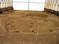
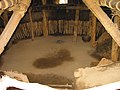
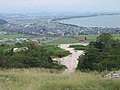
The Mukibanda site is located in the low foothills of Mount Daisen,[3] at an elevation of between 90 metres (300 ft) and 120 metres (390 ft) above sea level, and covers 170 hectares (420 acres). The settlement was naturally protected by the foothills of Mount Daisen, yet had close access to Miho Bay on the Sea of Japan, which is clearly visible from the site.[3] It is divided into several discreet areas along the hill ridge. Continuing excavations have confirmed the remains of more than 420 pit dwellings, more than 500 pillar-supported buildings, and more than 30 burial mounds. It is estimated that there are more than 1,000 buildings including unexplored areas, making it one of the largest settlements in the Yayoi period.[4]
Discovery edit
Construction of a golf course and large-scale "Daisen Swiss Village" resort was planned on the site in the early 1990s by the Keihan Group, but after an examination of the area by the Boards of Education of Daisen and Yodoe, now Yonago City, between 1995 and 1998, a national-level conservation movement sought to protect the area from development.[3] The ruins cover an area of 156 hectares.
Districts edit
The Mukibanda Yayoi remains are divided into seven districts.
- Sentani
- Muki Niiyama
- Mukiyama
- Matsuogashira
- Komaishi
- Shimizu
- Matsuojo[1]
Excavation edit
Roughly 1/20th of the Mukibanda remains have been excavated.[5] The 17.2 hectares (43 acres) of excavation revealed 395 pit-style dwellings, 502 dwellings with raised cornerstones, and 24 Yayoi-style barrow cliff tombs.[3] This area was inhabited between the late Yayoi to early Kofun period, roughly 100 BC to 300 AD.[5] The east part of the site was occupied by dwellings, and the western part of the site, on higher ground, was used for gravesites. The settlement was active in blacksmithing, bead making, and the production of earthenware Yayoi pottery. The highest point on the site in the Matsuogashira district of Daisen appears to be the home of the chief of the village and home to the sacred area of the site.[3] The entire site is thought to be the chief village, and possibly capitol, of some type of political entity.[5] The Mukibanda site is likely part of ancient Kingdom of Izumo[6] The existence of ring trenches dating from the latter half of the Yayoi period indicate that the settlement was fortified at some point, roughly corresponding to the time of the Civil War of Wa mentioned in Chinese historical sources. Remains unearthed include earthenware, stone tools (cooking tools, agricultural tools, hunting tools, weapons), ironware (agricultural tools, weapons), and broken mirrors. A total of 197 ironware items from the Yayoi period, such as hatchets, axes, chisels, drilling tools, hoe tips, sickles, and iron arrowheads, have been excavated, and some of them are of continental origin.[4]
Remains edit
Visiting the site edit
The Mukibanda remains are open to the public. Tours, demonstrations, special events, and reconstructions at the site can be seen throughout the year.[7]
Access edit
The Mukibanda remains are closest to the JR West San'in Main Line Yonago Station (15 minute bus ride), but is also accessible from the JR West San'in Main and Inbi lines at Tottori Station (2 hour bus ride). The site is accessible by road via the San'in Expressway, Japan National Route 431, and Japan National Route 9.[8]
Gallery edit
-
 Protected grave
 -
 Mukiniiyama area
 -
 Remains of a dwelling
 -
 Reconstruction of a dwelling
 -
 Donohara area


See also edit
References edit
- ^ a b "Muki-Banda Remains". Archived from the original on 2012-09-04. Retrieved 2012-04-07.
- ^ "妻木晩田遺跡" (in Japanese). Agency for Cultural Affairs. Retrieved January 2, 2023.
- ^ a b c d e f "Mukibanda-iseki (妻木晩田遺跡)". Nihon Rekishi Chimei Taikei (日本歴史地名大系 (in Japanese). Tokyo: Shogakukan. 2012. Archived from the original on 2007-08-25. Retrieved 2012-04-07.
- ^ a b Isomura, Yukio; Sakai, Hideya (2012). (国指定史跡事典) National Historic Site Encyclopedia. 学生社. ISBN 4311750404.(in Japanese)
- ^ a b c 妻木晩田遺跡とは?(in Japanese)
- ^ 史跡名勝天然記念物:妻木晩田遺跡 詳細解説(in Japanese)
- ^ むきばんだ史跡公園のイベントカレンダー(in Japanese)
- ^ むきばんだ史跡公園のアクセス(in Japanese)
External links edit
- Muki-Banda Remains
- Mukibanda Historical Site, Yonago Tourist Site
- 妻木晩田遺跡 史跡名勝記念物(in Japanese)
- Visitors' brochure(in Japanese)
- 大阪府立弥生文化博物館 (Museum of Yayoi Culture, Osaka)(in Japanese)