


Summary
Mungar is a rural locality in the Fraser Coast Region, Queensland, Australia.[2] In the 2021 census, Mungar had a population of 328 people.[3]
| Mungar Queensland | |||||||||||||||
|---|---|---|---|---|---|---|---|---|---|---|---|---|---|---|---|
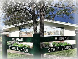 Mungar State School, 2023 | |||||||||||||||
 Mungar | |||||||||||||||
| Coordinates | 25°36′10″S 152°35′40″E / 25.6027°S 152.5944°E | ||||||||||||||
| Population | 328 (SAL 2021)[1] | ||||||||||||||
| Postcode(s) | 4650 | ||||||||||||||
| Area | 15.2 km2 (5.9 sq mi) | ||||||||||||||
| Time zone | AEST (UTC+10:00) | ||||||||||||||
| Location |
| ||||||||||||||
| LGA(s) | Fraser Coast Region | ||||||||||||||
| State electorate(s) | Maryborough | ||||||||||||||
| Federal division(s) | Wide Bay | ||||||||||||||
| |||||||||||||||
Geography edit
Mungar is 256 kilometres (159 mi) north of the state capital Brisbane and 19.7 kilometres (12.2 mi) south west of the regional centre of Maryborough.[4][5]
The locality is bounded to the east by the Mary River.[6]
Mungar Road traverses the locality from north to south.[6]
The North Coast railway line enters the locality from the south (Antigua) and exits to the north (Grahams Creek). It is west of Mungar Road. The locality is served by the Mungar railway station (25°36′12″S 152°35′38″E / 25.6033°S 152.5940°E).[6][7]
History edit
Mary River Saw Mill Provisional School opened on 9 July 1875. On 24 September 1877, it was renamed Mungar State School.[8]
The Mungar Junction to Monto Branch Railway branched from the North Coast railway line at Mungar railway station. The first section of the line from Mungar to Teebar (now known as Brooweena) opened on 29 July 1889.[9] The final opening of the line through to its terminus in Monto was on 15 September 1928.[10] The last train ran on the branch railway in 2008 and the line was officially closed in 2012.[11]
Demographics edit
At the 2011 census, Mungar and the surrounding area had a population of 264.[12]
In the 2016 census, Mungar had a population of 309 people.[13]
In the 2021 census, Mungar had a population of 328 people.[3]
Education edit

Mungar State School is a government primary (Prep-6) school for boys and girls at 1143 Mungar Road (25°36′15″S 152°35′26″E / 25.6041°S 152.5906°E).[14][15] In 2017, the school had an enrolment of 44 students with 3 teachers (2 full-time equivalent) and 4 non-teaching staff (3 full-time equivalent).[16] In 2018, the school had an enrolment of 52 students with 4 teachers (3 full-time equivalent) and 6 non-teaching staff (4 full-time equivalent).[17]
There are no secondary schools in Mungar. The nearest government secondary school is Aldridge State High School in Maryborough to the north-east.[18]
References edit
- ^ Australian Bureau of Statistics (28 June 2022). "Mungar (suburb and locality)". Australian Census 2021 QuickStats. Retrieved 28 June 2022.
- ^ "Mungar – locality in Fraser Coast Region (entry 46730)". Queensland Place Names. Queensland Government. Retrieved 16 November 2019.
- ^ a b Australian Bureau of Statistics (28 June 2022). "Mungar (SAL)". 2021 Census QuickStats. Retrieved 28 February 2023.
- ^ Google (18 December 2023). "Brisbane to Mungar" (Map). Google Maps. Google. Retrieved 18 December 2023.
- ^ Google (18 December 2023). "Maryborough to Mungar" (Map). Google Maps. Google. Retrieved 18 December 2023.
- ^ a b c "Queensland Globe". State of Queensland. Retrieved 18 December 2023.
- ^ "Railway stations and sidings - Queensland". Queensland Open Data. Queensland Government. 2 October 2020. Archived from the original on 5 October 2020. Retrieved 5 October 2020.
- ^ Queensland Family History Society (2010), Queensland schools past and present (Version 1.01 ed.), Queensland Family History Society, ISBN 978-1-921171-26-0
- ^ "Queensland News". Darling Downs Gazette. Vol. XXXI, no. 7, 307. Queensland, Australia. 31 July 1889. p. 1 (SUPPLEMENT TO THE DARLING DOWNS GAZETTE.). Retrieved 18 December 2023 – via National Library of Australia.
- ^ "RAILWAY OPENED". Queensland Times. Vol. LXIX, no. 13, 253. Queensland, Australia. 17 September 1928. p. 9. Retrieved 18 December 2023 – via National Library of Australia.
- ^ Gough, Emma (7 June 2012). "Last train out of Monto gone". News Regional Media. Archived from the original on 9 December 2023. Retrieved 18 December 2023.
- ^ Australian Bureau of Statistics (31 October 2012). "Mungar (State Suburb)". 2011 Census QuickStats. Retrieved 13 June 2015.
- ^ Australian Bureau of Statistics (27 June 2017). "Mungar (SSC)". 2016 Census QuickStats. Retrieved 20 October 2018.
- ^ "State and non-state school details". Queensland Government. 9 July 2018. Archived from the original on 21 November 2018. Retrieved 21 November 2018.
- ^ "Mungar State School". Mungar State School. 28 July 2022. Archived from the original on 1 March 2023. Retrieved 18 December 2023.
- ^ "ACARA School Profile 2017". Archived from the original on 22 November 2018. Retrieved 22 November 2018.
- ^ "ACARA School Profile 2018". Australian Curriculum, Assessment and Reporting Authority. Archived from the original on 27 August 2020. Retrieved 28 January 2020.
- ^ "Layers: Locality; Schools and school catchments". Queensland Globe. Queensland Government. Archived from the original on 19 December 2017. Retrieved 13 September 2023.