


Summary
The Municipal Borough of Farnworth was a local government district centred on the town of Farnworth in the administrative county of Lancashire, England. A local board of health had been established for Farnworth in 1863, which was reconstituted as an urban district in 1899, before being granted a charter of incorporation to become a municipal borough in 1939. Following abolition of the local authority in 1974, Farnworth became an unparished area of the Metropolitan Borough of Bolton in Greater Manchester.
| Municipal Borough of Farnworth | |
|---|---|
 | |
| Area | |
| • 1911 | 1,504 acres (6.1 km2)[1] |
| • 1961 | 1,503 acres (6.1 km2)[1] |
| Population | |
| • 1901 | 25,925 |
| • 1971 | 28,862 |
| History | |
| • Created | 1863 |
| • Abolished | 1974 |
| • Succeeded by | Metropolitan Borough of Bolton |
| Status |
|
| Government | |
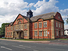
| • HQ | Farnworth Town Hall |
| • Motto | Latin: Juste Nec Timide (Be just and fear not)[2] |
History edit
Lying within the boundaries of the historic county of Lancashire since the early 12th century, Farnworth constituted a township in the civil and ecclesiastical parish of Deane.[3][4] In 1837, Farnworth became part of the Bolton Poor Law Union which took responsibility for funding the Poor Law in that Union area.[5]
Under the Local Government Act 1858, a local board of health was adopted for the township of Farnworth in 1863.[6] In 1866, Farnworth was also given the status of a civil parish.[7] After the Public Health Act 1875 was passed by Parliament in that year, Farnworth Local Board of Health assumed extra duties as an urban sanitary district, although the Local Board's title did not change.[8]
In 1899, following the implementation of the Local Government Act 1894, Farnworth Local Board was reconstituted as an elected urban district council of eighteen members.[9] Farnworth Urban District Council had six electoral wards, each denoted by points of the compass (North, North-East, North-West, South, South-East, and South-West wards), and each represented by three councillors.[9][10] In 1939, Farnworth was granted a charter of incorporation to become a municipal borough.[11]
Under the Local Government Act 1972, the Municipal Borough of Farnworth was abolished on 1 April 1974 and its former area was transferred to Greater Manchester to become an unparished area of the Metropolitan Borough of Bolton.[4]
Demography edit
|
|
| ||||||||||||||||||||||||||||||||||||
| Sources: Urban Sanitary District (USD) 1891.[10][12] Urban District (UD) and Municipal Borough (MB) 1901–1971.[10][13] | ||||||||||||||||||||||||||||||||||||||
Lists of office holders edit
Chairmen of Farnworth Local Board edit
| Chairmen of Farnworth Local Board, 1863–1899 | ||||
|---|---|---|---|---|
| Name | Party | Tenure | Notes | |
| Alfred Barnes | Liberal | 1863–1867 |
1st term | |
| David Crossley | Liberal | 1867–1868 |
||
| John Hindley | Conservative | 1868–1869 |
||
| Alfred Topp | Liberal | 1869–1870 |
1st term | |
| William Barton Whittam | — | 1870–1872 |
1st term | |
| John Greenhalgh | — | 1872–1875 |
||
| Alfred Topp | Liberal | 1875–1878 |
2nd term. Afterwards was Chairman of Farnworth Urban District Council (1901–1904) | |
| Alfred Barnes | Liberal | 1878–1880 |
2nd term | |
| William Barton Whittam | — | 1880–1881 |
2nd term | |
| James Nuttall | Liberal | 1881–1885 |
||
| Joseph Winter | Liberal | 1885–1886 |
||
| George Foster | Liberal | 1886–1887 |
||
| John Clelland Clarke | Liberal | 1888–1894 |
||
| Nathaniel Nicholson | Conservative | 1895–1897 |
||
| Thomas Ivers | Liberal | 1897–1899 |
||
| Source(s):[11] | ||||
Chairmen of Farnworth Urban District Council edit
| Chairmen of Farnworth Urban District Council, 1899–1939 | ||||
|---|---|---|---|---|
| Name | Party | Tenure | Notes | |
| William Sumner | — | 1899–1901 |
||
| Alfred Topp | Liberal | 1901–1904 |
Previously Chairman of Farnworth Local Board (1869–1870, and 1875–1878) | |
| Thomas Ivers | Liberal | 1904–1906 |
||
| Thomas Stanley | Conservative | 1906–1909 |
||
| Frederick Whittaker | Conservative | 1909–1912 |
||
| Charles Young | Conservative | 1912–1914 |
||
| William Boyes Richardson | Liberal | 1914–1915 |
||
| James Stones | Conservative | 1915–1919 |
||
| John Chadwick | Conservative | 1919–1921 |
||
| Charles Strathnairn Jackson | Labour | 1921–1923 |
||
| Richard Henry Cunliffe | Liberal | 1923–1925 |
||
| Thomas White | Conservative | 1925–1926 |
||
| Walter Robert Winter | Labour | 1926–1928 |
||
| Harry Barnes | Labour | 1928–1930 |
||
| The Rev. John Wilcockson | Labour | 1930–1932 |
Afterwards was Mayor of Farnworth (1939–1940) | |
| George Tomlinson | Labour | 1932–1933 |
Afterwards was Member of Parliament for Farnworth (1938–1952) | |
| James Stevenson | Labour | 1934–1936 |
Afterwards was Mayor of Farnworth (1940–1941) | |
| Samuel Taylor | Liberal | 1936–1937 |
||
| Alfred Jones | Labour | 1938–1939 |
Afterwards was Mayor of Farnworth (1941–1942) | |
| Source(s):[11] | ||||
Mayors of the Municipal Borough of Farnworth edit
| Mayors of the Municipal Borough of Farnworth, 1939–1974 | ||||
|---|---|---|---|---|
| Name | Party | Tenure | Notes | |
| The Rev. John Wilcockson | Labour | 1939–1940 |
Previously Chairman of Farnworth Urban District (1930–1932) | |
| James Stevenson, JP | Labour | 1940–1941 |
||
| Alfred Jones, JP, OBE | Labour | 1941–1942 |
Previously Chairman of Farnworth Urban District (1938–1939) | |
| William McManus | Labour | 1942–1943 |
||
| John Heathcoate | Labour | 1943–1944 |
||
| Jesse Seddon, JP, MC | Conservative | 1944–1945 |
||
| Richard Ralphson | Labour | 1945–1946 |
||
| Harold Greenwood Holland | Labour | 1946–1947 |
||
| James Alfred Dean | Labour | 1947–1949 |
||
| William Welsby | Labour | 1949–1950 |
||
| John Brooks | Labour | 1950–1951 |
||
| George Henry Wilson | Liberal | 1951–1952 |
||
| Richard Matthews | Labour | 1952–1953 |
||
| Harold Armitage | Labour | 1953–1954 |
||
| Robert Neary, JP | Labour | 1954–1955 |
||
| James Melville White | Labour | 1955–1956 |
||
| James Wilfred Geere | Labour | 1956–1957 |
||
| John Glanville Seddon | Labour | 1957–1958 |
||
| George Benyon | Labour | 1958–1959 |
||
| John Higgins | Labour | 1959–1960 |
||
| Albert Samuel Royse, JP, MBE | Conservative | 1960–1961 |
||
| Herbert Brindle | Labour | 1961–1962 |
||
| Philip Smith | Labour | 1962–1963 |
||
| Phillip Norfield | Labour | 1963–1964 |
||
| Sydney Stout | Labour | 1964–1965 |
||
| George Kenyon Brown | Labour | 1965–1966 |
||
| Norman Topping | Labour | 1966–1967 |
||
| Charles Brendan Callaghan | Labour | 1967–1968 |
||
| Lawrence Francis Cunliffe | Labour | 1968–1969 |
||
| Joseph Wild | Labour | 1969–1970 |
||
| Leonard Haslam | Labour | 1970–1971 |
||
| William Hardman | Labour | 1971–1972 |
||
| Elizabeth Brown | Labour | 1972–1973 |
||
| Joseph Kenneth Flanagan | Labour | 1973–1974 |
||
| Source(s):[11] | ||||
Neighbouring districts edit
The Municipal Borough of Farnworth was surrounded to the north and west by the County Borough of Bolton, to the northeast by Little Lever Urban District, to the southeast by Kearsley Urban District, and to the south by Little Hulton Urban District until 1933, then by Worsley Urban District.
Notes edit
- ^ a b Great Britain Historical GIS Project. "Farnworth UD/MB: Area (acres)". A Vision of Britain through Time. University of Portsmouth. Retrieved 12 May 2008.
- ^ Young, Robert. "Pre-1974 Civic Heraldry of Lancashire". Civic Heraldry of England and Wales. Retrieved 12 May 2008.
- ^
Farrer, William; Brownbill, J., eds. (1911). "Salford hundred: The parish of Deane". A History of the County of Lancaster. Vol. 5. British History Online. pp. 1–5. Retrieved 9 August 2016.
{{cite book}}:|work=ignored (help) - ^ a b "Greater Manchester Gazetteer". Greater Manchester County Record Office. Place names - D to F. Archived from the original on 18 July 2011. Retrieved 12 May 2008.
- ^ Higginbotham, Peter. "The Workhouse: Bolton, Lancashire". The Workhouse: The story of an institution... Retrieved 28 November 2010.
- ^ Great Britain Historical GIS Project. "Farnworth USD: Relationships and changes". A Vision of Britain through Time. University of Portsmouth. Retrieved 12 May 2008.
- ^ Great Britain Historical GIS Project. "Farnworth CP/Ch: Relationships and changes". A Vision of Britain through Time. University of Portsmouth. Retrieved 12 May 2008.
- ^ Great Britain Historical GIS Project. "Farnworth USD: Relationships and changes". A Vision of Britain through Time. University of Portsmouth. Retrieved 12 May 2008.
- ^ a b
Farrer, William; Brownbill, J., eds. (1911). "Townships: Farnworth". A History of the County of Lancaster. Vol. 5. British History Online. pp. 34–39. Retrieved 9 August 2016.
{{cite book}}:|work=ignored (help) - ^ a b c Tatton, Pauline. Local population statistics 1801–1986: abbreviated tables compiled from census statistics for Bolton. Bolton Libraries.
- ^ a b c d Links in a Chain Project. "Farnworth 1863-1974". Links in a Chain. Retrieved 6 May 2008.
- ^ Great Britain Historical GIS Project. "Farnworth USD: Males & Females". A Vision of Britain through Time. University of Portsmouth. Retrieved 9 August 2016.
- ^ Great Britain Historical GIS Project. "Farnworth UD/MB: Total Population". A Vision of Britain through Time. University of Portsmouth. Retrieved 12 May 2008.
External links edit
- Boundary Map of Farnworth UD/MB
53°32′43″N 2°24′00″W / 53.5452°N 2.3999°W