


Summary
The N53 road is a national secondary road in Ireland, running from Dundalk, County Louth, to Castleblayney, County Monaghan, but with a short gap where it crosses the Republic of Ireland–United Kingdom border and runs through Northern Ireland.
 | |
|---|---|
| Bóthar N53 | |
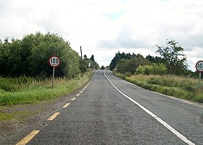 The N53 at the Armagh / Louth border, entering the Republic | |
| Route information | |
| Length | 17.5 km (10.9 mi) |
| Location | |
| Country | Ireland |
| Primary destinations | |
| Highway system | |
The road was established before the partition of Ireland and became Concession Road in Northern Ireland owing to its lack of formal custom facilities. The cross-border location of the N53 has attracted businesses taking advantage of different laws and taxes, but also created problems following Brexit, which may see border facilities established on the road for the first time.
Route edit
The N53 is 23.5 kilometres (14.6 mi) long, including the section in Northern Ireland.[1] It runs from junction 17 of the M1 at Newtownbalregan just outside Dundalk, County Louth, to the N2 bypass of Castleblayney, County Monaghan. For 6 kilometres (3.7 mi) (between Rassan, County Louth, and Ballynacarry Bridge, County Monaghan) the road passes through Cullaville, County Armagh, Northern Ireland, where it is classified as the A37 and known as the Concession Road. The southern border crossing is at a tripoint of Counties Armagh, Monaghan and Louth.[2][3]
History edit

The road pre-dates the partition of Ireland in 1921. It is mentioned in Samuel Lewis' A Topographical Dictionary of Ireland (1837), which describes the parish of Castletown as "on the bay of Dundalk, and on the roads leading respectively to Castle-Blayney and Armagh".[4] It was never intended to be a cross-border road; had the border been defined by the Irish Boundary Commission's recommendations instead of existing county boundaries, the road would have been entirely in the Republic.[5]
Concession Road was named because there were no customs at the border, and vehicles in the Republic were allowed to travel from Dundalk to Castleblayney without having to stop for checks. Legally, nobody living in Northern Ireland was allowed to cross the border using the N53, and should have used a manned crossing. In practice, locals used the road anyway. A formal customs post existed just south of Cullaville at Kingham's Bridge by the River Fane. It was destroyed by the Provisional IRA in 1971.[3]
On 6 February 1972, a British soldier, David Seaman, was found dead on the road in a suspected IRA activity.[6] In December 1976, a woman was driving along the road when she collided with a lorry hijacked by the IRA.[7]
Safety edit
The N53 has a poor safety record, and has been described as an "accident blackspot". Various widening and bypass proposals have been put forward.[8] In 2011, a councillor complained that the road around Dundalk was unsafe to walk on, because of a lack of pedestrian access.[9]
In 2013, the contracting firm MDM were consulted by both Monaghan County Council and the Northern Ireland Department of Regional Development on a new bridge crossing the River Fane, diverting from Ballynacarry Bridge.[10]
In 2018, a section of N53 from Rassan to Hackballscross was closed for a month, for major restructuring works.[11]
In December 2022, a man was killed while driving on the N53 close to the border, when he was hit by a car. Police suggested the incident may be linked to a murder in Castleblayney that took place shortly before.[12][13]
Commerce edit
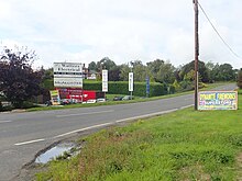
The road's geography, connecting two points in the Republic via Northern Ireland has made it popular for businesses taking advantages of the two country's different taxes. The Concession Road has nine fuel outlets, both catering for long-distance traffic and agricultural diesel. There are also a number of off licences, car sales and fireworks shops.[3]
Brexit edit
Following the 2016 United Kingdom European Union membership referendum, in which the United Kingdom voted to leave the European Union, concern was raised over whether formal border posts should appear on the N53, as it would form an external border with the EU, which is opposed by local residents in Amargh.[3] In 2017, the EU's chief negotiator Michel Barnier was photographed on the southern section of the N53 by the border.[14]
In 2018, the EU Exit Analysis Branch identified fifteen main roads, including the N53, which could be used as a key border inspection point should a hard Brexit occur.[15]
At a 2022 Louth County Council meeting, discussing safety improvements to the N53, a local councillor remarked there was still a possibility of border checks on the road being required, depending on the progression of the Northern Ireland Protocol designed to facilitate post-Brexit trade between Northern Ireland and the Republic. He quipped that the road could become the "Boris Johnson junction" if checkpoints would be required, or the "Martin McGuinness motorway" if the fallout of Brexit ultimately led to a United Ireland.[8]
See also edit
- Drummully, another cross-border traffic area
References edit
- ^ "N53". Google Maps. Archived from the original on 12 April 2023. Retrieved 12 April 2023.
- ^ "Roads Act 1993 (Classification of National Roads) Order 2006". Department of Transport. 13 April 2006. Archived from the original on 12 April 2023. Retrieved 12 April 2023.
- ^ a b c d "Concession Road: Where the Border fuels business". Irish Times. 20 October 2018. Archived from the original on 12 April 2023. Retrieved 12 April 2023.
- ^ Lewis, Samuel (1837). A Topographical Dictionary of Ireland. Archived from the original on 12 April 2023. Retrieved 12 April 2023.
- ^ "Irish Boundary Commission Report". National Archives. 1925. p. 130. Archived from the original on 26 November 2020. Retrieved 12 April 2023.
- ^ Mulroe 2017, p. 78.
- ^ Mulroe 2017, p. 173.
- ^ a b "N53 could be 'Boris Johnson junction' or 'Martin McGuinness motorway'". Irish Independent. 19 May 2022. Archived from the original on 12 April 2023. Retrieved 12 April 2023.
- ^ "Cllr. claims 'Blayney Road too dangerous". Irish Independent. 13 April 2011. Archived from the original on 13 April 2023. Retrieved 13 April 2023.
- ^ "Project - Ballynacarry Bridge Feasibility Study". MDM Engineering. 2013. Archived from the original on 13 April 2023. Retrieved 13 April 2023.
- ^ "Section of Dundalk to Castleblayney Road to close for one month". Dundalk Democrat. 28 August 2018. Archived from the original on 12 April 2023. Retrieved 12 April 2023.
- ^ "Gardaí probe possible link between two deaths". Irish News. 2 December 2022. Archived from the original on 12 April 2023. Retrieved 12 April 2023.
- ^ "Investigation after two bodies found near Irish border". BBC News. 1 December 2022. Archived from the original on 12 April 2023. Retrieved 12 April 2023.
- ^ "There is always an answer, says Barnier as Brexit border dominates Ireland visit". Belfast Telegraph. 12 April 2023. Archived from the original on 12 April 2023. Retrieved 12 April 2023.
- ^ "More than 45 million vehicles crossing border between north and the Republic annually". The Irish News. 28 September 2018. Archived from the original on 28 September 2018. Retrieved 12 April 2023.
- Mulroe, Patrick (2017). Bombs, Bullets and the Border : Ireland's Frontier: Irish Security Policy, 1969–1978. Irish Academic Press. p. 78. ISBN 978-1-911-02452-1.