


Summary
Nangan Township (Chinese: 南竿鄉) is a rural township in the Matsu Islands and the county seat of Lienchiang County, Fujian.[3]
Nangan
南竿鄉 (Chinese) Nankan | |
|---|---|
| Nangan Township | |
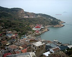 Fuxing Village in Nangan Township | |
 Nangan Township in Lienchiang County | |
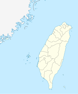 Nangan Location in the Republic of China | |
| Coordinates: 26°09′N 119°56′E / 26.150°N 119.933°E | |
| Country | |
| Province | Fujian (government suspended) |
| County | Lienchiang |
| Rural villages | 9 |
| Government | |
| • Mayor | Chen Chen-ko (陳振國) (KMT) |
| Area | |
| • Total | 10.64 km2 (4.11 sq mi) |
| Population (March 2023)[2] | |
| • Total | 7,815 |
| • Density | 730/km2 (1,900/sq mi) |
| Postal code | 209 |
| Area code | (0)836 |
| Website | http://www.nankan.gov.tw/ |
| Nangan, Lienchiang | |||||||||||||||||||||||
|---|---|---|---|---|---|---|---|---|---|---|---|---|---|---|---|---|---|---|---|---|---|---|---|
| Traditional Chinese | 南竿鄉 | ||||||||||||||||||||||
| |||||||||||||||||||||||

There is an airport in Nangan. The highest point is Yuntai Mountain, at 248 m (814 ft) above sea level.
Name edit
Nangan Township is named for Nangan Island (Nankan Island[4]), the main island in the township. Nangan was also known Nangantang (南竿塘;[5] Nàng-găng-dòng). Because Lin Moniang's (who later became the Goddess Mazu) bodily relic was claimed to be washed ashore here, Nangan was also known as Matsu Island / Ma-tsu Island / Matsu Shan / Matsu-Shan[6] (Matsoo[7]/ Matsoo shan[8]) (馬祖島;[5] Mā-cū-dō̤). In Song and Ming records, Nangan Island (Matsu Island) was called Shanggantang/Shanggantangshan (上竿塘/上干塘/上竿塘山) as opposed to Beigan Island, which was called Xiagantang/Xiagantangshan (下竿塘/下干塘/下竿塘山).[9][10]
History edit
In 1935, a baojia was created including Nangan Island.[11]
In 1949, ROC forces were stationed on Nangan Island.[11]
At 3 AM on January 9, 1966, three seamen from the PRC defected to the ROC at Nangan (Nankan) Island. They were ambushed and killed in transit to Taipei.[12]
In 2000, as part of the Three Links, transportation between Nangan Island's Fuao and Mawei District in Fuzhou was established.[11]
In 2003, Nangan Airport was opened.[11]
On the morning of May 4, 2016, Jiaonan Village (in Tailu, Lianjiang County, Fuzhou, Fujian, China (PRC)) Branch Chinese Communist Party Secretary Liu Wenjian (刘文件) and Niujiao Community Assistant Manager Tsao Erh-Chang (曹爾章) met in Nangan Township and signed a memorandum of mutual exchange and cooperation. Others present included the Magistrate of Lienchiang County, ROC Liu Cheng-ying, Tailu Party Secretary Huang Duanming (黄端明), Nangan Township Mayor Chen Chen-Ko (陳振國) and others.[13]
Geography edit
The island of Nangan is not only the largest island of its township, but also the largest island of Matsu. Nangan Township is also the largest township in Lienchiang County, with a population of about 4,000. The highest point of the island is the Mount Yuntai peak at 248 meters.[14] Nangan's climate is classified as subtropical, with distinct seasons. The average year-round temperature is 20C, with July and August reaching 34C and January temperatures as low as 1.8C. There is an intense fog period during March and April which often affects the scheduled flights at Nangan Airport.

Other islets in Nangan Township include Huangguan Yu (黃官嶼), Xie Jiao (鞋礁), Beiquan Jiao (北泉礁), and Liuquan Jiao (劉泉礁).[15]
Politics and government edit
Administrative divisions edit
There are 10 villages on Nangan. At the eastern end of the island is Jieshou (介壽村), the seat of the county government and the largest village. Following the coastal road west from Jieshou, there are Fuxing (復興村), Fuao (福澳村), Qingshui (清水村), Zhuluo (珠螺村) and Mazu (馬祖村). Following the mountain road west, there are Meishi (梅石村), Renai (仁愛村) and Jinsha (津沙聚落), before once again reaching Mazu. Located to the north of Mazu is Siwei (四維村). In addition to these, there are two smaller villages or clusters of homes. These are Furen (夫人村) and Ketiao (科蹄澳), they are located near Siwei.
Many villages on Nangan have two names. In some cases, this was the result of politics, as one is the traditional name and the second has a political connotation. These instances are paired as follows with the traditional name first: Shanlong (山隴): Jieshou (介壽), Niujiao (牛角(聚落)): Fuxing (復興), Tieban (鐵板): Renai (仁愛), and Fuao (福澳): Jingze (經澤). These names are often used interchangeably by residents, except for Jingze. Residents objected to this latter name, and so it never came into popular use. The reference to Shanlong is also important as there is a neighborhood there called Zhonglong (中隴). Mazu is also referred to as Magang (馬港) and Siwei as Xiwei (西尾). As for Mazu and Magang, Magang is the preferred name. This could be in order to distinguish the village and its harbor from Mazu (媽祖), the goddess, and Mazu (馬祖) the island chain. Xiwei was derived from the local Fuzhou dialect's pronunciation of Siwei.
The nine rural villages of Nangan Township are:[16][17][18]
- Jieshou (Chiehshou; Chinese: 介壽村; Hanyu Pinyin: Jièshòu Cūn; Tongyong Pinyin: Jièshòu Cun) literally, "Longevity for Chiang Kai-shek "
- Jinsha (Chinsha; Chinese: 津沙村; Hanyu Pinyin: Jīnshā Cūn; Tongyong Pinyin: Jinsha Cun) "Sand of Seaport"
- Cingshuei / Qingshui (Chingshui; Chinese: 清水村; Hanyu Pinyin: Qīngshuǐ Cūn; Tongyong Pinyin: Cingshuěi Cun) "Pure Water"
- Jhuluo (Chuluo; Chinese: 珠螺村; Hanyu Pinyin: Zhūluó Cūn; Tongyong Pinyin: Jhuluó Cun) "Pearl and Snail"
- Fusing / Fuxing (Fuhsing; Chinese: 復興村; Hanyu Pinyin: Fùxīng Cūn; Tongyong Pinyin: Fùsing Cun) "Revive Prosperity"
- Fuwo (Chinese: 福沃村; Hanyu Pinyin: Fúwò Cūn; Tongyong Pinyin: Fúwò Cun) "Auspicious Fertility": Jingze Village (經澤)
- Ren-ai (Jenai; Chinese: 仁愛村; Hanyu Pinyin: Rén'ài Cūn; Tongyong Pinyin: Rén-ài Cun) "Humanity and Love": Tieban (鐵板 "Iron Plate") until 1955 .
- Matsu (Chinese: 馬祖村; Hanyu Pinyin: Mǎzǔ Cūn; Tongyong Pinyin: Mǎzǔ Cun; Wade–Giles: Ma3-tsu3 Ts'un1) "Matsu"
- Sihwei / Siwei (Szuwei; Chinese: 四維村; Hanyu Pinyin: Sìwéi Cūn; Tongyong Pinyin: Sìhwéi Cun) "Four Virtues"
Government institutions edit
Mayors edit
- Appointed mayors[19]
- Li Chun-Hua (李春華) (to Nov. 2, 1959)
- Nieh Ko-Tung (聶國棟) (Nov. 2, 1959-Nov. 15, 1960)
- Pan Fu (潘輔) (Nov. 15, 1960-Feb. 10, 1962), later mayor of Beigan
- Yu Te-Chu (尤德渠) (Feb. 10, 1962-Apr. 1, 1962), also mayor of Beigan
- Hsueh Chih-Lien (薛繼廉) (Apr. 1, 1962-Feb. 25, 1965), later mayor of Juguang
- Pan Fu (second term, 潘輔) (Feb. 25, 1965-Dec. 7, 1973)
- Chen I-Peng (陳一鵬) (Dec. 7, 1973-Jan. 1, 1978), former mayor of Beigan and Juguang
- Elected mayors
- Yeh Chin-Fu (葉金福) (Jan. 1, 1978-Mar. 1, 1982)
- Chang Hsiang-Shou (張祥壽) (Mar. 1, 1982-Mar. 1, 1986)
- Chiu Ying-Piao (邱英鑣) (Mar. 1, 1986-Mar. 1, 1990)
- Chen Shu-Li (陳書禮) (Mar. 1, 1990-Mar. 1, 1998)
- Chen Hsiu-Hua (陳秀華) (Mar. 1, 1998-Mar. 1, 2002)
- Lin Shu-Ching (林樹清) (Mar. 1, 2002-Mar. 1, 2006)
- Chu Hsiu-Ping (朱秀平) (Mar. 1, 2006-Dec. 12, 2014)
- Chen Chen-Ko (陳振國) (2014–present) (KMT),[20] in 2018 received nearly four-thousand votes[21]
Tourism edit

The Palace of Heavenly Empress (天后宮) in Matsu Village contains the coffin of Lin Moniang.[clarification needed] The temple also contains statues of the guards, Thousand-li Eye (千里眼) and Wind-following Ear (順風耳). There is an annual celebration on March 3.
Matsu Distillery on Wujiao Hill (午角嶺) in Fusing Village produces daqu wine (大麴酒) and sorghum wine (高梁酒).
Shengli Water Reservoir (勝利水庫 "Victory") and a museum are located in Cingshuei village. The museum contains four cannons from Jyuguang which were used to guide boats. Another museum is the Matsu Blue Tears Ecological Museum, Matsu Folk Culture Museum and Ching-kuo Memorial Hall.
There are two abandoned military tunnels on the island: Tunnel 88 and Beihai Tunnel. Former military stronghold is Dahan Stronghold.
Nature in the township is Shengtian Park and Mount Yuntai.
Infrastructure edit

Nangan was initially powered by Matsu Power Plant which was funded by the Ministry of National Defense, Taiwan Power Company and the Matsu Administration Committee in 1969 and was commissioned on 1 July 1971. Starting March 2010, the electricity for the township is supplied by Zhushan Power Plant.[22]
The main hospital of the township is Lienchiang County Hospital.
Transportation edit
Air edit

- Uni Air is the only airline serving the island, with eight flights a day to Nangan Airport and three flights a day to Beigan Airport. All of the above flights arrive at Songshan Airport in Taipei with the exception of one flight at Taichung Airport in Taichung.
Water edit
- Commercial boat rides are provided hourly every day from 7am to 5pm. The rides take approximately 10 minutes to Beigan.
- Commercial boat rides to Juguang Island takes approximately an hour with three rides a day.
- There are ferryboat scheduled on a weekly basis between Keelung Port and Nangan's Fuao Harbor.
Road edit
The township has bus services connecting its villages, which consists of coastal line and mountain line.[23]
Education edit
Schools in Nangan include:
- National Matsu Senior High School (國立馬祖高級中學) - operated by the national government[24]
- Operated by the county government
- Lienchiang County Nangan County Chung Cheng Junior High & Elementary School (連江縣南竿鄉立中正國民中小學)[25]
- Lienchiang County Jie-Shou Junior High & Elementary School (連江縣立介壽國民中小學)[26]
- Lienchiang County Ren Ai Elementary School (連江縣南竿鄉仁愛國民小學)[27]
-
 Jie-Shou Junior High & Elementary School (連江縣立介壽國民中小學)
 -
 Lienchiang County Nangan County Chung Cheng Junior High & Elementary School (連江縣南竿鄉立中正國民中小學)


Notable natives edit
- Yang Sui-sheng, Magistrate of Lienchiang County (2009–2014)
See also edit
References edit
- ^ 本鄉簡介. Nangan Township Administration, Matsu (in Chinese (Taiwan)). Retrieved 8 September 2019.
本鄉(南竿)為馬祖列島第一大島,舊稱「南竿塘」,面積10.64平方公里,實際居住島上的居民約四、五千人。
- ^ 截至106年6月底 馬祖總人口數12716人. Matsu Daily (in Chinese (Taiwan)). 14 July 2016. Retrieved 8 September 2019.
南竿鄉:1607戶,7442人,較103年7288人增加154人;男性4175人、女性3267人。
- ^ "Nangan – Matsu National Scenic Area". Matsu-nsa.gov.tw. 2012-08-13. Retrieved 2014-04-23.
- ^ DeWitt Copp; Marshall Peck (1962). The Odd Day. New York City: William Morrow & Company. pp. 58, 59, 66, 67, n121, n123, n124, n125, 202, 203, 207 – via Internet Archive.
NANKAN{...}One hundred and fifty miles north of Quemoy on Nankan Island,{...}Between Nankan and Peikan lay the Matsu Straits, a twisted riptide-torn channel, boasting freak winds and bouldered shores.
- ^ a b 辞海第六版. Cihai (Sixth Edition) (in Chinese). 上海. Shanghai: 上海辞书出版社. Shanghai Lexicographical Publishing House. September 2009. p. 1516. ISBN 978-7-5326-2859-9.
马祖列岛 中国闽江口外25~40千米的岛群。总面积约20平方千米,人口约1万。属福建省连江县,现由台湾当局管辖。{...}由马祖岛(又称南竿塘)、{...}组成。
- ^ "FOREIGN RELATIONS OF THE UNITED STATES, 1955–1957, CHINA". Office of the Historian, US Department of State. Washington, D.C. 16 March 1955. Retrieved 28 August 2019.
158. National Intelligence Estimate{...}3.In the context of this estimate the term "Matsu Group" or "Matsus" denotes those Chinese Nationalist-held islands lying essentially between 25 and 27 degrees north latitude and consisting of Tung-yin Shan, Lang Tao, Kao-teng Hsu, Pei-kan Tang, Matsu Shan, Pai-chuan and Lieh Tao (White Dogs), Wu-chiu, and Hsia Wu-chiu. "Matsu" used singly applies only to Matsu-Shan proper.
- ^ "Map showing the Island of Formosa and the adjoining coast of China". Library of Congress. Retrieved 24 August 2019.
Matsoo
- ^ "Sailing directions to accompany seven charts of the coast of China, between Amoy bay, and the Yángtsz' kiáng". The Chinese Repository. Vol. XII, no. 8. Canton. August 1843. p. 411 – via Internet Archive.
Due north of the Western White Dog is a large island called Matsoo shan 馬祖山,
- ^ Meng-hsing Ho 何孟興. 明代福州海防要地「竿塘山」之研究(1368–1456年) [Research on the strategic coast defense position 'Gan-Tang-Shan' in Fu-Jhou in Ming Dynasty]. Chaoyang University of Technology (in Chinese (Taiwan)). Retrieved 3 September 2019.
- ^ 北竿鄉志 第一章:北竿開發史 [History of Beigan Chapter One: Earliest Records of Beigan]. 馬祖資訊網 (in Chinese (Taiwan)). Retrieved 2 September 2019.
民國十六年修的《連江縣志》描寫其地理位置:「南竿塘山,即上竿塘,北竿塘山即下竿塘,二山在定海外東南海中,遙遙並峙…」。
- ^ a b c d 地方沿革 (in Chinese (Taiwan)). Retrieved 8 September 2019.
- ^ "Translations on People's Republic of China No. 445". United States Joint Publications Research Service. 24 July 1978. p. 47. Retrieved 18 August 2019 – via Internet Archive.
- ^ 馬祖日報2016/05/04影音/苔菉鎮茭南村、牛角社協簽署交流合作備忘錄 (in Chinese (Taiwan)). Matsu Daily. 4 May 2016. Archived from the original on 2021-12-21. Retrieved 17 March 2020 – via YouTube.
- ^ "Yuntai Mountain". Taiwan, the Heart of Asia. 2 April 2008. Retrieved 2 June 2022.
- ^ 擬定連江縣風景特定區計畫說明書 [Proposed Lienchiang County Designated Scenic Areas Plan Manual] (PDF). June 2002. pp. iii, 8. Archived from the original (PDF) on 8 January 2020.
- ^ 各村村長辦公處、電話. Nangan Township Administration, Matsu (in Chinese (Taiwan)). Retrieved 8 September 2019.
村名{...}介壽村{...}復興村{...}福沃村{...}清水村{...}珠螺村{...}馬祖村{...}仁愛村{...}津沙村{...}四維村{...
} - ^ "Brief introduction of Nangan Township". Nankan Township Administration, Matsu. Retrieved 8 September 2019.
the settlement of the Aokou tribe, like Jieshou, Fuxing, Fuwo, Qingshui, Jhuluo, Sihwei. Matsu, Jinsha, Ren-ai etc.
- ^ Robert Storey (1998). Taiwan. Lonely Planet. p. 320. ISBN 978-0-86442-634-5 – via Internet Archive.
Fuhsing Village Chiehshou Village Fuwo Village Chingshui Village Jenai Village Chinsha Village Chuluo Village Matsu Village Fujen Village Szuwei Village
- ^ 歷屆鄉長任期一覽表. Nangan Township Administration, Matsu (in Chinese (Taiwan)). Archived from the original on 19 January 2020. Retrieved 8 September 2019.
- ^ 鄉長陳振國 小檔案. Nangan Township Administration, Matsu (in Chinese (Taiwan)). Retrieved 8 September 2019.
- ^ 葉書宏 (25 November 2018). 莒光鄉決戰 謝春欗連任成功. China Times (in Chinese (Taiwan)). Retrieved 17 September 2019.
南竿鄉鄉長陳振國為連江縣議會前議長陳振清胞弟,陳家在連江縣為大姓,每4個馬祖人就有一個姓陳,陳振國延續胞兄的政治實力,近年來積極為鄉親們增取建設,爭取第2家航空公司進駐南竿機場,另外,還要增闢高雄及澎金旅遊包機航線,陳拿下近4000票。
- ^ "Hsieh-ho Power Plant - Zhushan Branch Power Plant". Taipower. 7 September 2020. Retrieved 7 December 2020.
- ^ "Island Transport". Matsu National Scenic Area. January 2010. Retrieved 25 September 2019.
- ^ "Home". National Matsu Senior High School. Retrieved 2024-02-05.
連江縣南竿鄉介壽村374號
- ^ "地理位置" [Location]. Lienchiang County Jie-Shou Junior High & Elementary School. Retrieved 2024-02-05.
連江縣(馬祖)南竿鄉馬祖村4號
- ^ "Profile Location". Lienchiang County Jie-Shou Junior High & Elementary School. Retrieved 2024-02-05.
連江縣(馬祖)南竿鄉介壽村13號
- ^ "地理位置" [Location]. Lienchiang County Ren Ai Elementary School. Retrieved 2024-02-05.
209 連江縣(馬祖)南竿鄉仁愛村95號