
KNOWPIA
WELCOME TO KNOWPIA

Nanjian Yi Autonomous County 
Summary
Nanjian Yi Autonomous County (simplified Chinese: 南涧彝族自治县; traditional Chinese: 南澗彝族自治縣; pinyin: Nánjiàn Yízú Zìzhìxiàn) is a county in the Dali Bai Autonomous Prefecture located in the west central part of Yunnan province, China.
Nanjian County
南涧县 | |
|---|---|
| 南涧彝族自治县 Nanjian Yi Autonomous County | |
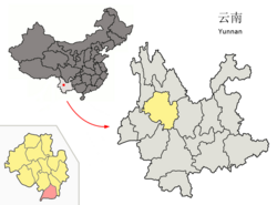 Location of Nanjian County (pink) and Dali Prefecture (yellow) within Yunnan | |
 Nanjian County  Nanjian County | |
| Coordinates: 25°02′35″N 100°30′00″E / 25.04306°N 100.50000°E | |
| Country | China |
| Province | Yunnan |
| Autonomous prefecture | Dali |
| County seat | Nanjian |
| Area | |
| • Total | 1,731.63 km2 (668.59 sq mi) |
| Population (2020 census)[1] | |
| • Total | 192,942 |
| • Density | 110/km2 (290/sq mi) |
| Time zone | UTC+8 (CST) |
| Postal code | 675700 |
| Area code | 0872 |
| Climate | Cwa |
| Website | www |
Administrative divisions edit
Nanjian Yi Autonomous County has 5 towns and 3 townships.[2]
- 5 towns
|
|
- 3 townships
- Yongcui (拥翠乡)
- Leqiu (乐秋乡)
- Bixi (碧溪乡)
Ethnic groups edit
The Nanjian County Gazetteer (1993) lists the following ethnic groups.
- Yi (Western and Central Yi languages)
- Black Yi, White Yi
- Luoluo 倮倮, Black Luoluo 黑倮倮, White Luoluo 白倮倮
- Tuzu 土族
- Xiangtang 香堂
- Micha 密岔
- Laluobo 腊罗拨/腊鲁拨
- Enibo 额尼拨 (Central Yi)
- Misabo 迷撒拨
- Hui
- Bai (only some can speak Bai)
- Miao
- White Miao 白苗 (Menglou 孟镂)
- Green Miao 青苗 (Mengsa 孟撒): in Guihuaqing 桂花箐,[3] Weibixi Township 唯碧溪乡
- Chinese Miao 汉苗 (Mengzhua 孟抓)
- Bulang (autonym: Pu 濮; exonyms: Puman 濮曼, Pumanzi 濮蛮子): along the Jiancang River 涧沧江 in Wangjiang 望江,[4] Wanzi 湾子,[5] Lelongzhai 乐龙寨,[6] Goujie 狗街,[7] Yanzijiao 岩子脚,[8][9] Luodihe 落底河[10]
- Lisu
- Han
In Nanjian County, ethnic Bulang are located in Banqiao Village 板桥村,[11] Langcang Township 浪沧乡 (Dali Prefecture Gazetteer, Vol. 9 1998:127).
Transportation edit
Climate edit
| Climate data for Nanjian (1991–2020 normals, extremes 1981–2010) | |||||||||||||
|---|---|---|---|---|---|---|---|---|---|---|---|---|---|
| Month | Jan | Feb | Mar | Apr | May | Jun | Jul | Aug | Sep | Oct | Nov | Dec | Year |
| Record high °C (°F) | 26.5 (79.7) |
29.7 (85.5) |
31.4 (88.5) |
34.6 (94.3) |
36.1 (97.0) |
35.7 (96.3) |
34.2 (93.6) |
33.9 (93.0) |
34.2 (93.6) |
31.7 (89.1) |
28.7 (83.7) |
25.7 (78.3) |
36.1 (97.0) |
| Mean daily maximum °C (°F) | 20.5 (68.9) |
22.7 (72.9) |
25.8 (78.4) |
28.3 (82.9) |
29.5 (85.1) |
29.9 (85.8) |
28.8 (83.8) |
29.1 (84.4) |
28.3 (82.9) |
26.3 (79.3) |
23.4 (74.1) |
20.8 (69.4) |
26.1 (79.0) |
| Daily mean °C (°F) | 12.3 (54.1) |
14.7 (58.5) |
18.1 (64.6) |
20.9 (69.6) |
23.4 (74.1) |
24.8 (76.6) |
23.9 (75.0) |
23.5 (74.3) |
22.4 (72.3) |
19.9 (67.8) |
15.6 (60.1) |
12.6 (54.7) |
19.3 (66.8) |
| Mean daily minimum °C (°F) | 5.6 (42.1) |
7.7 (45.9) |
11.1 (52.0) |
14.7 (58.5) |
18.3 (64.9) |
21.1 (70.0) |
20.7 (69.3) |
20.0 (68.0) |
18.7 (65.7) |
15.8 (60.4) |
10.1 (50.2) |
6.4 (43.5) |
14.2 (57.5) |
| Record low °C (°F) | 0.5 (32.9) |
2.4 (36.3) |
0.6 (33.1) |
9.1 (48.4) |
11.2 (52.2) |
14.8 (58.6) |
15.4 (59.7) |
14.8 (58.6) |
11.3 (52.3) |
9.0 (48.2) |
3.4 (38.1) |
−0.8 (30.6) |
−0.8 (30.6) |
| Average precipitation mm (inches) | 22.8 (0.90) |
15.8 (0.62) |
20.9 (0.82) |
28.1 (1.11) |
60.4 (2.38) |
89.1 (3.51) |
150.3 (5.92) |
144.7 (5.70) |
99.7 (3.93) |
70.5 (2.78) |
28.3 (1.11) |
9.8 (0.39) |
740.4 (29.17) |
| Average precipitation days (≥ 0.1 mm) | 4.5 | 4.5 | 6.5 | 8.1 | 9.7 | 11.7 | 18.5 | 17.4 | 13.9 | 11.3 | 5.1 | 3.0 | 114.2 |
| Average snowy days | 0.1 | 0 | 0 | 0 | 0 | 0 | 0 | 0 | 0 | 0 | 0 | 0 | 0.1 |
| Average relative humidity (%) | 58 | 51 | 47 | 49 | 56 | 64 | 73 | 75 | 75 | 73 | 69 | 65 | 63 |
| Mean monthly sunshine hours | 233.2 | 221.8 | 247.4 | 243.5 | 227.8 | 166.9 | 129.6 | 146.3 | 149.2 | 173.0 | 212.2 | 225.4 | 2,376.3 |
| Percent possible sunshine | 70 | 69 | 66 | 64 | 55 | 41 | 31 | 37 | 41 | 49 | 65 | 69 | 55 |
| Source: China Meteorological Administration[12][13] | |||||||||||||
References edit
- ^ "大理州第七次全国人口普查主要数据公报" (PDF) (in Chinese). Dali Daily. 2021-06-01.
- ^ "国家统计局" (in Chinese). National Bureau of Statistics of the People's Republic of China. Retrieved 2021-12-07.
- ^ "南涧彝族自治县公郎镇凤凰桂花箐". Archived from the original on 2015-06-10. Retrieved 2013-08-19.
- ^ "南涧彝族自治县公郎镇落底河望江". Archived from the original on 2016-03-05. Retrieved 2013-08-19.
- ^ "南涧彝族自治县公郎镇落底河湾子". Archived from the original on 2016-03-05. Retrieved 2013-08-19.
- ^ "南涧彝族自治县公郎镇落底河落龙寨". Archived from the original on 2017-12-02. Retrieved 2013-08-19.
- ^ "南涧彝族自治县公郎镇落底河狗街". Archived from the original on 2016-03-05. Retrieved 2013-08-19.
- ^ "南涧彝族自治县公郎镇中山中山岩子脚". Archived from the original on 2016-03-05. Retrieved 2013-08-19.
- ^ "南涧彝族自治县公郎镇板桥板桥岩子脚". Archived from the original on 2017-12-02. Retrieved 2013-08-19.
- ^ "南涧彝族自治县公郎镇落底河". Archived from the original on 2017-12-01. Retrieved 2013-08-19.
- ^ "南涧彝族自治县公郎镇板桥". Archived from the original on 2015-06-10. Retrieved 2013-10-09.
- ^ 中国气象数据网 – WeatherBk Data (in Simplified Chinese). China Meteorological Administration. Retrieved 20 September 2023.
- ^ 中国气象数据网 (in Simplified Chinese). China Meteorological Administration. Retrieved 20 September 2023.
External links edit
- Nanjian County Official Website