
KNOWPIA
WELCOME TO KNOWPIA

National Register of Historic Places listings in Adams County, Ohio 
Summary
This is a list of the National Register of Historic Places listings in Adams County, Ohio.
This is intended to be a complete list of the properties and districts on the National Register of Historic Places in Adams County, Ohio, United States. The locations of National Register properties and districts for which the latitude and longitude coordinates are included below, may be seen in a Google map.[1]
There are 16 properties and districts listed on the National Register in the county, including 1 National Historic Landmark.
This National Park Service list is complete through NPS recent listings posted April 5, 2024.[2]
Current listings edit
| [3] | Name on the Register[4] | Image | Date listed[5] | Location | City or town | Description |
|---|---|---|---|---|---|---|
| 1 | Adams County Paleo-Indian District | 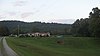 |
October 17, 1974 (#74001389) |
North of U.S. Route 52 near Sandy Springs[6] 38°36′48″N 83°17′39″W / 38.613333°N 83.294167°W | Green Township | |
| 2 | Buckeye Station | 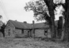 |
May 1, 1974 (#74001388) |
East of Manchester off U.S. Route 52 38°42′22″N 83°32′31″W / 38.70621°N 83.54194°W | Monroe Township | |
| 3 | Cockerill House | 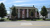 |
November 21, 1978 (#78001998) |
115 E. Main St. 38°47′41″N 83°32′42″W / 38.79459°N 83.54508°W | West Union | |
| 4 | Dayton Power and Light Company Mound |  |
July 30, 1974 (#74001391) |
On the grounds of the Dayton Power and Light's Killen Station plant, east of Wrightsville[7] 38°41′20″N 83°28′41″W / 38.689000°N 83.478000°W | Monroe Township | |
| 5 | Harshaville Covered Bridge |  |
March 16, 1976 (#76001357) |
Graces Run Rd.[8] 38°54′28″N 83°32′37″W / 38.90787°N 83.54374°W | Oliver Township | |
| 6 | Kirker Covered Bridge |  |
October 29, 1975 (#75001309) |
Southwest of West Union off State Route 136 38°47′03″N 83°36′12″W / 38.78416°N 83.60328°W | Liberty Township | |
| 7 | Gov. Thomas Kirker Homestead | 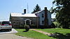 |
November 3, 1975 (#75001310) |
Southwest of West Union off State Route 136 38°46′28″N 83°35′57″W / 38.7745°N 83.59905°W | Liberty Township | |
| 8 | Dr. A.C. Lewis House | 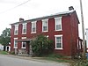 |
October 31, 1980 (#80002931) |
103 South St. 38°56′28″N 83°39′04″W / 38.94112°N 83.65109°W | Winchester | |
| 9 | Serpent Mound |  |
October 15, 1966 (#66000602) |
5 mi (8.0 km) northwest of Locust Grove on State Route 73 39°01′33″N 83°25′49″W / 39.02573°N 83.43031°W | Bratton Township | |
| 10 | The Ridge | 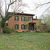 |
October 8, 1992 (#92001352) |
503 E. 8th St. 38°41′37″N 83°36′16″W / 38.69349°N 83.60437°W | Manchester | |
| 11 | Treber Inn |  |
May 17, 1976 (#76001358) |
5 mi (8.0 km) northeast of West Union on State Route 41 38°50′57″N 83°29′14″W / 38.84921°N 83.4871°W | Tiffin Township | |
| 12 | Wamsley Village Site |  |
July 30, 1974 (#74001390) |
West of Stout, near the mouth of Brush Creek. On the grounds of the Dayton Power and Light's Killen Station plant[9][10] 38°40′35″N 83°27′07″W / 38.676333°N 83.451806°W | Monroe Township | |
| 13 | West Union Presbyterian Church |  |
November 18, 1976 (#76001359) |
108 S. 2nd St. 38°47′37″N 83°32′38″W / 38.7935°N 83.54375°W | West Union | |
| 14 | Wickerham Inn |  |
May 7, 1979 (#79001778) |
Northeast of Peebles on State Route 41 38°58′13″N 83°23′39″W / 38.97038°N 83.39414°W | Franklin Township | |
| 15 | John T. Wilson Homestead |  |
April 11, 1977 (#77001039) |
Northeast of Seaman on State Route 770 38°57′48″N 83°31′57″W / 38.9633°N 83.53263°W | Scott Township | |
| 16 | Tet Woods Building |  |
March 25, 1982 (#82003536) |
307 Main St. 38°47′41″N 83°32′52″W / 38.79477°N 83.54787°W | West Union |
Former listing edit
| [3] | Name on the Register | Image | Date listed | Date removed | Location | City or town | Description |
|---|---|---|---|---|---|---|---|
| 1 | Sinton Homestead | June 10, 1975 (#14000763) | August 18, 1975 | 114 E. Main St. | West Union | Demolished on August 18, 1975. |
See also edit
Wikimedia Commons has media related to National Register of Historic Places in Adams County, Ohio.
- List of National Historic Landmarks in Ohio
- Listings in neighboring counties: Brown, Highland, Lewis (KY), Mason (KY), Pike, Scioto
- National Register of Historic Places listings in Ohio
References edit
- ^ The latitude and longitude information provided in this table was derived originally from the National Register Information System, which has been found to be fairly accurate for about 99% of listings. Some locations in this table may have been corrected to current GPS standards.
- ^ National Park Service, United States Department of the Interior, "National Register of Historic Places: Weekly List Actions", retrieved April 5, 2024.
- ^ a b Numbers represent an alphabetical ordering by significant words. Various colorings, defined here, differentiate National Historic Landmarks and historic districts from other NRHP buildings, structures, sites or objects.
- ^ "National Register Information System". National Register of Historic Places. National Park Service. April 24, 2008.
- ^ The eight-digit number below each date is the number assigned to each location in the National Register Information System database, which can be viewed by clicking the number.
- ^ Location derived from this Archived 2010-07-02 at the Wayback Machine map (key Archived 2010-07-02 at the Wayback Machine) from the Ohio Valley Regional Development Commission; the NRIS lists the site as "Address Restricted"
- ^ Location derived from this EPA document, page 61; the NRIS lists the site as "Address Restricted"
- ^ DeLorme. Ohio Atlas & Gazetteer. 7th ed. Yarmouth: DeLorme, 2004, p. 83. ISBN 0-89933-281-1. NRIS lists it at the nonexistent State Route 1.
- ^ Location derived from its Federal Register notice; the NRIS lists the site as "Address Restricted"
- ^ Location derived from Brady-Rawlins, Kathleen. The O.C. Voss Site: Reassessing What We Know about the Fort Ancient Occupation of the Central Scioto Drainage and Its Tributaries. Diss. Ohio State University, 2007, 176. The NRIS lists the site as "Address Restricted".