
KNOWPIA
WELCOME TO KNOWPIA

National Register of Historic Places listings in Adams County, Washington 
Summary
This list presents the full set of buildings, structures, objects, sites, or districts designated on the National Register of Historic Places in Adams County, Washington, and offers brief descriptive information about each of them. The National Register recognizes places of national, state, or local historic significance across the United States.[1] Out of over 90,000 National Register sites nationwide,[2] Washington is home to approximately 1,500,[3] and 12 of those are found in Adams County.

This National Park Service list is complete through NPS recent listings posted April 5, 2024.[4]
Current listings edit
| [5] | Name on the Register[6] | Image | Date listed[7] | Location | City or town | Description |
|---|---|---|---|---|---|---|
| 1 | Adams County Courthouse |  |
December 7, 2018 (#100003256) |
210 W. Broadway Ave. 47°07′38″N 118°22′56″W / 47.1272°N 118.3821°W | Ritzville | |
| 2 | Bassett Hardware Co. Store | 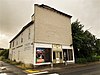 |
May 15, 2022 (#100007729) |
305 South Main St. 46°45′02″N 118°18′58″W / 46.7506°N 118.3161°W | Washtucna | |
| 3 | Dr. Frank R. Burroughs House |  |
November 20, 1975 (#75001838) |
408 West Main Avenue 47°07′31″N 118°22′59″W / 47.12523°N 118.38315°W | Ritzville | |
| 4 | Denver and Rio Grande Western Railroad Business Car No. 101 | 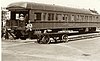 |
June 16, 1988 (#88000740) |
In Bruce, Washington, about 6 miles (9.7 km) east of Othello 46°50′09″N 119°02′56″W / 46.83584°N 119.04902°W | Othello | |
| 5 | Nelson H. Greene House |  |
March 7, 1980 (#80003996) |
502 South Adams Street 47°07′22″N 118°22′34″W / 47.12277°N 118.37598°W | Ritzville | |
| 6 | Ritzville Carnegie Library |  |
August 3, 1982 (#82004192) |
302 West Main Avenue 47°07′35″N 118°22′55″W / 47.12629°N 118.38207°W | Ritzville | Also a contributing property to Ritzville Historic District. |
| 7 | Ritzville High School |  |
May 19, 1994 (#94000476) |
7th Avenue, between South Columbia Street and South Division Street 47°07′25″N 118°22′19″W / 47.12357°N 118.372°W | Ritzville | Building demolished in 2013. |
| 8 | Ritzville Historic District | 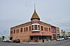 |
May 2, 1990 (#90000676) |
Roughly bounded by Broadway Avenue, North Division Street, West Railroad Avenue, and North Adams Street 47°07′37″N 118°22′51″W / 47.1269°N 118.38085°W | Ritzville | |
| 9 | Seivers Brothers Ranchhouse and Barn | 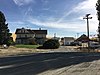 |
June 19, 1979 (#79002524) |
On Providence Road, about 6.5 miles (10.5 km) southeast of Lind 46°54′43″N 118°30′31″W / 46.91182°N 118.50866°W | Lind | |
| 10 | Spokane, Portland and Seattle Railway Company-Cow Creek Viaduct |  |
December 31, 2018 (#100003278) |
Milepost 304.4 former SP&S RR line 46°50′34″N 118°08′37″W / 46.8428°N 118.1436°W | Ankeny vicinity | |
| 11 | Spokane, Portland and Seattle Railway Company Bridge 291.4--O.W.R.&N. Crossing-Washtucna |  |
December 31, 2018 (#100003279) |
Milepost 291.4, former SP&S line crossing Yeisley Rd. 46°45′09″N 118°17′58″W / 46.7526°N 118.2995°W | Washtucna vicinity | |
| 12 | Strap Iron Corral |  |
August 1, 1975 (#75001837) |
On Cow Creek, about 5.8 miles (9.3 km) north of Hooper 46°50′19″N 118°07′36″W / 46.83874°N 118.12663°W | Hooper |
See also edit
References edit
- ^ Andrus, Patrick W.; Shrimpton, Rebecca H.; et al. (2002), How to Apply the National Register Criteria for Evaluation, National Register Bulletin, National Park Service, U.S. Department of the Interior, retrieved June 20, 2014.
- ^ National Park Service, National Register of Historic Places Program: Research, retrieved January 28, 2015.
- ^ Department of Archaeology and Historic Preservation, Washington Information System for Architectural and Archaeological Records Data (WISAARD), retrieved February 14, 2015.
- ^ National Park Service, United States Department of the Interior, "National Register of Historic Places: Weekly List Actions", retrieved April 5, 2024.
- ^ Numbers represent an alphabetical ordering by significant words. Various colorings, defined here, differentiate National Historic Landmarks and historic districts from other NRHP buildings, structures, sites or objects.
- ^ "National Register Information System". National Register of Historic Places. National Park Service. April 24, 2008.
- ^ The eight-digit number below each date is the number assigned to each location in the National Register Information System database, which can be viewed by clicking the number.
External links edit
- Washington Department of Archaeology and Historic Preservation, Historic Register program
- National Park Service, National Register of Historic Places site
 Media related to National Register of Historic Places in Adams County, Washington at Wikimedia Commons