
KNOWPIA
WELCOME TO KNOWPIA

National Register of Historic Places listings in Ashe County, North Carolina 
Summary
This list includes properties and districts listed on the National Register of Historic Places in Ashe County, North Carolina. Click the "Map of all coordinates" link to the right to view an online map of all properties and districts with latitude and longitude coordinates in the table below.[1]

Current listings edit
This National Park Service list is complete through NPS recent listings posted April 12, 2024.[2]
| [3] | Name on the Register[4] | Image | Date listed[5] | Location | City or town | Description |
|---|---|---|---|---|---|---|
| 1 | Shubal V. Alexander Archeological District | September 1, 1978 (#78001928) |
Address Restricted | Crumpler | ||
| 2 | Ashe County Courthouse | 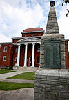 |
May 10, 1979 (#79001658) |
301 E. Main St. 36°25′15″N 81°28′13″W / 36.420833°N 81.470278°W | Jefferson | |
| 3 | Ashe County Memorial Hospital |  |
April 28, 2015 (#15000179) |
410 McConnell St. 36°25′02″N 81°28′46″W / 36.417222°N 81.479444°W | Jefferson | |
| 4 | Baptist Chapel Church and Cemetery | 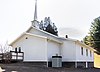 |
November 13, 1976 (#76001302) |
E of Helton on SR 1527 36°32′51″N 81°26′42″W / 36.5475°N 81.445°W | Helton | |
| 5 | Bower-Cox House |  |
November 7, 1976 (#76001303) |
SW of Scottville on SR 1595 36°26′43″N 81°21′52″W / 36.445278°N 81.364444°W | Scottville | |
| 6 | Brinegar District | March 21, 1978 (#78001929) |
Address Restricted | Crumpler | ||
| 7 | Clark-Miller Roller Mill |  |
August 19, 2014 (#14000491) |
180 Long Branch Rd. 36°30′23″N 81°31′17″W / 36.5065°N 81.5213°W | Lansing | |
| 8 | Cockerham Mill |  |
December 10, 2014 (#14001022) |
1580 Dog Creek Rd. Extension 36°25′04″N 81°23′03″W / 36.4179°N 81.3842°W | Cockerham | |
| 9 | A.S. Cooper Farm |  |
September 24, 2001 (#01001028) |
Cranberry Springs Rd., approx. 0.2 miles SE of jct. with Todd RR Grade Rd. 36°16′33″N 81°32′56″W / 36.275833°N 81.548889°W | Brownwood | |
| 10 | Samuel Cox House |  |
November 7, 1976 (#76001304) |
SW of Scottville off U.S. 221 on SR 1636 36°28′28″N 81°18′51″W / 36.474444°N 81.314167°W | Scottville | |
| 11 | Elkland School Gymnasium |  |
June 22, 2004 (#04000646) |
10279 Three Top Rd., NC 1100 at jct. of NC 194 36°18′55″N 81°36′00″W / 36.315278°N 81.6°W | Todd | |
| 12 | Glendale Springs Inn |  |
October 10, 1979 (#79003326) |
NC 16 and SR 1632 36°20′42″N 81°22′52″W / 36.345°N 81.381111°W | Glendale Springs | |
| 13 | Grassy Creek Historic District | December 12, 1976 (#76001300) |
SR 1535 and SR 1573 36°33′53″N 81°23′08″W / 36.564722°N 81.385556°W | Grassy Creek | ||
| 14 | R. T. Greer and Company Root and Herb Warehouse |  |
April 18, 2003 (#03000269) |
7181 Railroad Grade Rd., jct. of Todd Railroad Grad Rd. at Cranberry Springs Rd. 36°16′43″N 81°33′14″W / 36.278611°N 81.553889°W | Todd | |
| 15 | Lansing Historic District | August 18, 2011 (#11000544) |
Roughly bounded by NC 194, G & A Sts. 36°29′59″N 81°30′39″W / 36.499722°N 81.510833°W | Lansing | Ashe County, North Carolina, c. 1799-1955 MPS | |
| 16 | Lansing School |  |
January 8, 2009 (#08001288) |
East side of NC 194 at junction with NC 1517 36°30′01″N 81°30′19″W / 36.500278°N 81.505278°W | Lansing | |
| 17 | Miller Homestead |  |
September 24, 2001 (#01001029) |
324 Miller Dr. 36°29′32″N 81°33′25″W / 36.492222°N 81.556944°W | Lansing | |
| 18 | Cicero Pennington Farm |  |
September 11, 2018 (#100002925) |
630 Spencer Branch Rd. 36°33′50″N 81°29′14″W / 36.5639°N 81.4873°W | Sturgills | |
| 19 | Perry-Shepherd Farm | April 19, 2006 (#06000289) |
410 Swansie Shepherd Rd. 36°30′34″N 81°33′55″W / 36.509444°N 81.565278°W | Lansing | ||
| 20 | John M. Pierce House |  |
November 7, 1976 (#76001298) |
N of Crumpler on SR 1559 36°31′52″N 81°20′58″W / 36.531111°N 81.349444°W | Crumpler | |
| 21 | Poe Fish Weir | May 22, 1978 (#78001930) |
Address Restricted | Jefferson | ||
| 22 | Thompson's Bromine and Arsenic Springs |  |
October 22, 1976 (#76001299) |
W of Crumpler on SR 1542 36°30′08″N 81°23′45″W / 36.502222°N 81.395833°W | Crumpler | |
| 23 | Todd Historic District | January 28, 2000 (#00000017) |
Along Todd Railroad Grade Rd., Big Hill Rd., and Carter Miller Rd. 36°18′32″N 81°35′51″W / 36.308889°N 81.5975°W | Todd | ||
| 24 | John W. Tucker House |  |
July 29, 1985 (#85001685) |
State Route 1353 36°31′16″N 81°33′09″W / 36.521111°N 81.5525°W | Tuckerdale | |
| 25 | William Waddell House |  |
November 7, 1976 (#76001301) |
West of Grassy Creek off NC 16 on State Route 1532 36°34′09″N 81°26′17″W / 36.569167°N 81.438056°W | Grassy Creek | |
| 26 | West Jefferson Historic District | 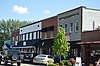 |
October 5, 2007 (#07001076) |
Roughly bounded by State St., 3rd Ave., 2nd St.& Wilton Ave. 36°24′07″N 81°29′32″W / 36.401944°N 81.492222°W | West Jefferson | |
| 27 | Worth's Chapel |  |
September 28, 2005 (#05001097) |
175 Three Top Rd. 36°27′54″N 81°37′16″W / 36.465°N 81.621111°W | Creston |
See also edit
Wikimedia Commons has media related to National Register of Historic Places in Ashe County, North Carolina.
References edit
- ^ The latitude and longitude information provided in this table was derived originally from the National Register Information System, which has been found to be fairly accurate for about 99% of listings. Some locations in this table may have been corrected to current GPS standards.
- ^ National Park Service, United States Department of the Interior, "National Register of Historic Places: Weekly List Actions", retrieved April 12, 2024.
- ^ Numbers represent an alphabetical ordering by significant words. Various colorings, defined here, differentiate National Historic Landmarks and historic districts from other NRHP buildings, structures, sites or objects.
- ^ "National Register Information System". National Register of Historic Places. National Park Service. April 24, 2008.
- ^ The eight-digit number below each date is the number assigned to each location in the National Register Information System database, which can be viewed by clicking the number.