
KNOWPIA
WELCOME TO KNOWPIA

National Register of Historic Places listings in Avery County, North Carolina 
Summary
This list includes properties and districts listed on the National Register of Historic Places in Avery County, North Carolina. Click the "Map of all coordinates" link to the right to view an online map of all properties and districts with latitude and longitude coordinates in the table below.[1]
This National Park Service list is complete through NPS recent listings posted April 12, 2024.[2]
Current listings edit
| [3] | Name on the Register[4] | Image | Date listed[5] | Location | City or town | Description |
|---|---|---|---|---|---|---|
| 1 | Avery County Courthouse |  |
May 10, 1979 (#79001660) |
Montezuma St., Courthouse Dr. and Glenn Hicks Lane 36°05′12″N 81°55′37″W / 36.086667°N 81.926944°W | Newland | |
| 2 | Avery County Jail |  |
December 9, 1999 (#99001494) |
1829 Schultz Cir. and Glenn Hicks Lane 36°05′12″N 81°55′34″W / 36.086631°N 81.926003°W | Newland | former jail that now houses the Avery Historical Museum |
| 3 | Banner Elk Hotel | 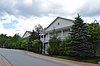 |
October 6, 2000 (#00001182) |
309 Banner St. 36°09′38″N 81°52′19″W / 36.160556°N 81.871944°W | Banner Elk | |
| 4 | Banner Elk School |  |
September 18, 2017 (#100001628) |
185 Azalea Cir. 36°09′46″N 81°52′12″W / 36.162778°N 81.870000°W | Banner Elk | |
| 5 | Crossnore Presbyterian Church | March 1, 1996 (#96000206) |
US 221/NC 194 E side, opposite jct. with Dellinger Rd. 36°01′06″N 81°55′47″W / 36.018364°N 81.929747°W | Crossnore | ||
| 6 | Crossnore School Historic District | February 18, 2009 (#09000059) |
Within the campus of Crossnore School, N. side of NC 1143, opposite junction with NC 1148 36°01′25″N 81°55′47″W / 36.023494°N 81.929811°W | Crossnore | ||
| 7 | Elk Park School | 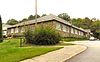 |
December 16, 2005 (#05001410) |
253 Elk Park School Rd. 36°09′41″N 81°58′49″W / 36.161389°N 81.980278°W | Elk Park | former school built by the Works Progress Administration; now a senior citizen living center |
| 8 | Edwin Cochran Guy House | December 10, 2021 (#100007245) |
320 Wanteska St. 36°05′13″N 81°55′47″W / 36.0869°N 81.9296°W | Newland | ||
| 9 | Linville Falls Tavern (former) |  |
December 28, 2000 (#00001554) |
25 Rock House Ln. 35°57′32″N 81°56′34″W / 35.958889°N 81.942778°W | Linville Falls | Now Famous Louise's Rock House Restaurant. Extends into Burke County as well as McDowell County. |
| 10 | Linville Historic District |  |
March 7, 1979 (#79001659) |
U.S. 221 36°03′58″N 81°52′10″W / 36.066111°N 81.869444°W | Linville | |
| 11 | Robert Chester and Elsie H. Lowe House | May 1, 2013 (#13000226) |
1010 Shawneehaw Ave. 36°09′11″N 81°52′01″W / 36.153056°N 81.866944°W | Banner Elk | ||
| 12 | Weaving Room of Crossnore School | April 25, 2001 (#01000417) |
205 Johnson Ln. 36°01′25″N 81°55′50″W / 36.023611°N 81.930556°W | Crossnore | ||
| 13 | Milligan Shuford Wise and Theron Colbert Dellinger Houses |  |
August 27, 2008 (#08000811) |
152 and 158 Hemlock Ln., 142 Dellinger Rd., 110 Pine St. 36°01′13″N 81°55′48″W / 36.020278°N 81.930000°W | Crossnore | |
| 14 | Ray Wiseman House | 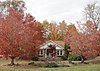 |
November 29, 1996 (#96001397) |
7540 Linville Falls Hwy. 35°59′34″N 81°56′34″W / 35.992778°N 81.942778°W | Altamont |
See also edit

Map of National Register of Historic Places listings in Avery County
Wikimedia Commons has media related to National Register of Historic Places in Avery County, North Carolina.
References edit
- ^ The latitude and longitude information provided in this table was derived originally from the National Register Information System, which has been found to be fairly accurate for about 99% of listings. Some locations in this table may have been corrected to current GPS standards.
- ^ National Park Service, United States Department of the Interior, "National Register of Historic Places: Weekly List Actions", retrieved April 12, 2024.
- ^ Numbers represent an alphabetical ordering by significant words. Various colorings, defined here, differentiate National Historic Landmarks and historic districts from other NRHP buildings, structures, sites or objects.
- ^ "National Register Information System". National Register of Historic Places. National Park Service. April 24, 2008.
- ^ The eight-digit number below each date is the number assigned to each location in the National Register Information System database, which can be viewed by clicking the number.