
KNOWPIA
WELCOME TO KNOWPIA

National Register of Historic Places listings in Beadle County, South Dakota 
Summary
This is a list of the National Register of Historic Places listings in Beadle County, South Dakota.

This is intended to be a complete list of the properties and districts on the National Register of Historic Places in Beadle County, South Dakota, United States. The locations of National Register properties and districts for which the latitude and longitude coordinates are included below, may be seen in a map.[1]
There are 27 properties and districts listed on the National Register in the county.
This National Park Service list is complete through NPS recent listings posted April 12, 2024.[2]
Current listings edit
| [3] | Name on the Register[4] | Image | Date listed[5] | Location | City or town | Description |
|---|---|---|---|---|---|---|
| 1 | Anderson Barn | August 15, 2003 (#03000763) |
19411 394th Street 44°34′29″N 98°20′35″W / 44.5747°N 98.3431°W | Hitchcock | ||
| 2 | Archeological Site No. 39BE3 | August 6, 1993 (#93000802) |
Address restricted[6] | Wolsey | ||
| 3 | Faye Bowden-Agnus Saunders House |  |
December 2, 1998 (#98001401) |
669 Dakota Ave., N. 44°22′26″N 98°12′52″W / 44.3740°N 98.2145°W | Huron | |
| 4 | Campbell Park Historic District of Huron |  |
November 5, 1974 (#74001888) |
Roughly bounded by 5th, 7th, 9th, Wisconsin, California, Kansas, and Dakota Sts. Boundary decrease (listed March 27, 2012, refnum 12000269): Roughly bounded by 5th St. SW, 9th St. SW, Wisconsin Ave. SW and Oregon Ave. SE 44°21′16″N 98°12′49″W / 44.3544°N 98.2136°W | Huron | |
| 5 | Chicago and North Western Roundhouse | 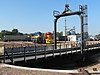 |
November 19, 1998 (#98001411) |
North of 1st St. 44°21′57″N 98°12′21″W / 44.3658°N 98.2058°W | Huron | |
| 6 | Dairy Building | January 25, 1990 (#90001642) |
Off 3rd St. near the South Dakota State Fair Grounds 44°21′47″N 98°13′47″W / 44.363056°N 98.229722°W | Huron | ||
| 7 | Hattie O. and Henry Drake Octagon House |  |
January 30, 1992 (#91002045) |
605 3rd St., SW. 44°21′49″N 98°13′26″W / 44.3636°N 98.2239°W | Huron | |
| 8 | Grace Episcopal Church | 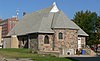 |
July 19, 1989 (#89000828) |
4th St. and Kansas Ave., SE. 44°21′42″N 98°12′46″W / 44.3618°N 98.2129°W | Huron | |
| 9 | Habicht & Habicht Department Store | 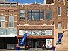 |
June 30, 2020 (#100005318) |
274 Dakota Ave. South 44°21′49″N 98°12′51″W / 44.3636°N 98.2141°W | Huron | |
| 10 | Jefferson School |  |
November 15, 2019 (#100004620) |
855 Utah Ave. SE 44°21′24″N 98°12′27″W / 44.3568°N 98.2076°W | Huron | Now Huron Church of the Open Bible |
| 11 | Margaret and Vernon Moxon House |  |
February 10, 1999 (#98001409) |
1305 McDonald St. 44°21′04″N 98°13′26″W / 44.3512°N 98.2240°W | Huron | Misspelled "Maxon" in the listing.[7] |
| 12 | McMonies Barn | 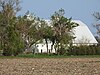 |
July 28, 2004 (#04000762) |
604 33rd Street, S.E. 44°19′31″N 98°12′13″W / 44.3252°N 98.2035°W | Huron | Feeder barn |
| 13 | Milford Hutterite Colony | June 30, 1982 (#82003909) |
Northeast of Lake Byron 44°36′48″N 98°03′17″W / 44.6133°N 98.0547°W | Carpenter | ||
| 14 | Old Riverside Hutterite Colony | 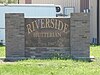 |
June 30, 1982 (#82003910) |
Off the James River 44°29′10″N 98°08′22″W / 44.4862°N 98.1395°W | Huron | |
| 15 | Albert S. Piper Homestead Claim Shanty | August 28, 1998 (#98001126) |
2 miles north of Lake Byron 44°36′01″N 98°08′35″W / 44.6003°N 98.1431°W | Carpenter | Shack built in 1882. | |
| 16 | Pyle House |  |
December 30, 1974 (#74002288) |
376 Idaho Avenue, S.E. 44°21′44″N 98°12′32″W / 44.3623°N 98.2088°W | Huron | |
| 17 | Site 39BE2 |  |
June 8, 2005 (#05000589) |
Address restricted[6] | Wessington Springs | |
| 18 | Site 39BE14 | |
January 30, 1984 (#84003199) |
Address restricted[6] | Huron | |
| 19 | Site 39BE15 | |
January 30, 1984 (#84003201) |
Address restricted[6] | Huron | |
| 20 | Site 39BE23 | |
January 30, 1984 (#84003206) |
Address restricted[6] | Huron | |
| 21 | Site 39BE46 | |
January 30, 1984 (#84003208) |
Address restricted[6] | Huron | |
| 22 | Site 39BE48 | |
January 30, 1984 (#84003210) |
Address restricted[6] | Huron | |
| 23 | Site 39BE57 | |
January 30, 1984 (#84003212) |
Address restricted[6] | Yale | |
| 24 | Site 39BE64 | |
January 30, 1984 (#84003215) |
Address restricted[6] | Yale | |
| 25 | South Dakota Dept. of Transportation Bridge No. 03-020-008 | December 9, 1993 (#93001260) |
Local road over unnamed creek 44°37′15″N 98°39′56″W / 44.620833°N 98.665556°W | Wessington | ||
| 26 | South Dakota Dept. of Transportation Bridge No. 03-327-230 |  |
December 9, 1993 (#93001261) |
Local road over Pearl Creek 44°17′49″N 98°02′24″W / 44.296944°N 98.04°W | Cavour | Scrapped in 2016. |
| 27 | South Dakota Dept. of Transportation Bridge No. 03-338-100 | December 9, 1993 (#93001269) |
Local road over Shue Creek 44°29′13″N 98°01′00″W / 44.486944°N 98.016667°W | Cavour |
See also edit
Wikimedia Commons has media related to National Register of Historic Places in Beadle County, South Dakota.
References edit
- ^ The latitude and longitude information provided in this table was derived originally from the National Register Information System, which has been found to be fairly accurate for about 99% of listings. Some locations in this table may have been corrected to current GPS standards.
- ^ National Park Service, United States Department of the Interior, "National Register of Historic Places: Weekly List Actions", retrieved April 12, 2024.
- ^ Numbers represent an alphabetical ordering by significant words. Various colorings, defined here, differentiate National Historic Landmarks and historic districts from other NRHP buildings, structures, sites or objects.
- ^ "National Register Information System". National Register of Historic Places. National Park Service. April 24, 2008.
- ^ The eight-digit number below each date is the number assigned to each location in the National Register Information System database, which can be viewed by clicking the number.
- ^ a b c d e f g h i Federal and state laws and practices restrict general public access to information regarding the specific location of this resource. In some cases, this is to protect archeological sites from vandalism, while in other cases it is restricted at the request of the owner. See: Knoerl, John; Miller, Diane; Shrimpton, Rebecca H. (1990), Guidelines for Restricting Information about Historic and Prehistoric Resources, National Register Bulletin, National Park Service, U.S. Department of the Interior, OCLC 20706997.
- ^ This house is listed in the National Register of Historic Places under the name "Margaret and Vernon Maxon House"; the surname is spelled "Maxon" throughout the NRHP nominating form. This is apparently an error. A sign on the lawn spells the name "Moxon". An obituary published by Huron's Kuhler Funeral Home and an obituary published in the Seattle Times give the decedent's name as "Margaret L. Moxon", and her late spouse's name as "Vernon Moxon" both formerly of Huron. The NRHP nominating form for the Edbert and Josie Opitz House, a Lustron house in Redfield, South Dakota, states that the original owners of the house were "Vernon and Margaret Moxon", who were "transferred to Huron in 1956"; the form spells the name "Moxon" a second time in that paragraph, but also spells it "Maxon". The nominating form for the Huron house states that "Mr. Maxon worked as a soil scientist"; one of the authors of "Soil Survey of Beadle County, South Dakota" is listed as "Vernon W. Moxon".