


Summary
This is a list of the National Register of Historic Places listings in Blackford County, Indiana.

This is intended to be a complete list of the properties and districts on the National Register of Historic Places in Blackford County, Indiana, United States. Latitude and longitude coordinates are provided for many National Register properties and districts; these locations may be seen together in a map.[1]
There are 4 properties and districts listed on the National Register in the county.
Properties and districts located in incorporated areas display the name of the municipality, while properties and districts in unincorporated areas display the name of their civil township. Properties and districts split between multiple jurisdictions display the names of all jurisdictions.
This National Park Service list is complete through NPS recent listings posted April 12, 2024.[2]
Current listings edit
| [3] | Name on the Register[4] | Image | Date listed[5] | Location | City or town | Description |
|---|---|---|---|---|---|---|
| 1 | Blackford County Courthouse |  |
August 11, 1980 (#80000053) |
Off State Road 3 40°27′06″N 85°22′05″W / 40.451667°N 85.368056°W | Hartford City | Built mostly during 1894, the courthouse is an outstanding example of the Richardsonian Romanesque style of architecture, and still retains its original appearance. The courthouse is the center of the Hartford City Courthouse Square Historic District. |
| 2 | First Presbyterian Church | 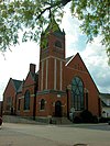 |
June 13, 1986 (#86001263) |
220 N. High St. 40°27′10″N 85°22′06″W / 40.452778°N 85.368333°W | Hartford City | Oldest church building in Blackford County; built in 1893 (during the Indiana Gas Boom) in the Richardsonian Romanesque style of architecture. Features huge stained-glass windows. |
| 3 | Hartford City Courthouse Square Historic District | 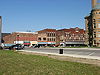 |
June 21, 2006 (#06000522) |
Roughly bounded by Franklin, Walnut, Water, and Monroe Sts. 40°27′05″N 85°22′05″W / 40.451389°N 85.368056°W | Hartford City | District was commercial, social, and governmental center of the city. Includes more than forty properties, most of which were constructed during the Indiana Gas Boom. |
| 4 | Montpelier Carnegie Library | 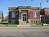 |
June 22, 2007 (#07000560) |
301 S. Main St. 40°33′10″N 85°16′41″W / 40.55283°N 85.278°W | Montpelier |
See also edit
References edit
- ^ The latitude and longitude information provided in this table was derived originally from the National Register Information System, which has been found to be fairly accurate for about 99% of listings. Some locations in this table may have been corrected to current GPS standards.
- ^ National Park Service, United States Department of the Interior, "National Register of Historic Places: Weekly List Actions", retrieved April 12, 2024.
- ^ Numbers represent an alphabetical ordering by significant words. Various colorings, defined here, differentiate National Historic Landmarks and historic districts from other NRHP buildings, structures, sites or objects.
- ^ "National Register Information System". National Register of Historic Places. National Park Service. March 13, 2009.
- ^ The eight-digit number below each date is the number assigned to each location in the National Register Information System database, which can be viewed by clicking the number.