
KNOWPIA
WELCOME TO KNOWPIA

National Register of Historic Places listings in Bradley County, Tennessee 
Summary
This is a list of the National Register of Historic Places listings in Bradley County, Tennessee.

This is intended to be a complete list of the properties and districts on the National Register of Historic Places in Bradley County, Tennessee, United States. Latitude and longitude coordinates are provided for many National Register properties and districts; these locations may be seen together in a map.[1]
There are 24 properties and districts listed on the National Register in the county.
| Anderson – Bedford – Benton – Bledsoe – Blount – Bradley – Campbell – Cannon – Carroll – Carter – Cheatham – Chester – Claiborne – Clay – Cocke – Coffee – Crockett – Cumberland – Davidson – Decatur – DeKalb – Dickson – Dyer – Fayette – Fentress – Franklin – Gibson – Giles – Grainger – Greene – Grundy – Hamblen – Hamilton – Hancock – Hardeman – Hardin – Hawkins – Haywood – Henderson – Henry – Hickman – Houston – Humphreys – Jackson – Jefferson – Johnson – Knox – Lake – Lauderdale – Lawrence – Lewis – Lincoln – Loudon – Macon – Madison – Marion – Marshall – Maury – McMinn – McNairy – Meigs – Monroe – Montgomery – Moore – Morgan – Obion – Overton – Perry – Pickett – Polk – Putnam – Rhea – Roane – Robertson – Rutherford – Scott – Sequatchie – Sevier – Shelby – Smith – Stewart – Sullivan – Sumner – Tipton – Trousdale – Unicoi – Union – Van Buren – Warren – Washington – Wayne – Weakley – White – Williamson – Wilson |
This National Park Service list is complete through NPS recent listings posted April 5, 2024.[2]
Current listings edit
| [3] | Name on the Register[4] | Image | Date listed[5] | Location | City or town | Description |
|---|---|---|---|---|---|---|
| 1 | Blue Springs Encampments and Fortifications |  |
April 16, 1999 (#99000427) |
West of Blue Springs off Lead Mine Valley Rd., SW. 35°05′27″N 84°55′14″W / 35.090833°N 84.920556°W | Cleveland | |
| 2 | Broad Street United Methodist Church |  |
April 5, 1984 (#84003263) |
263 Broad St., NW 35°09′41″N 84°52′33″W / 35.161389°N 84.875833°W | Cleveland | |
| 3 | C.C. Card Auto Company Building |  |
July 22, 2014 (#14000083) |
125 Inman & 162 1st Sts. 35°09′30″N 84°52′27″W / 35.1584°N 84.8741°W | Cleveland | |
| 4 | Centenary Avenue Historic District |  |
April 1, 1993 (#93000172) |
Roughly bounded by 8th, Harle, 13th, and Ocoee Sts. 35°10′03″N 84°52′29″W / 35.1675°N 84.874722°W | Cleveland | |
| 5 | Charleston Cumberland Presbyterian Church |  |
July 12, 1984 (#84003444) |
Railroad St. 35°17′05″N 84°45′14″W / 35.284722°N 84.753889°W | Charleston | |
| 6 | Cleveland Commercial Historic District | 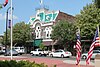 |
May 5, 2017 (#16000115) |
Roughly bounded by 50-100 blk. of Central Ave., 10-100 blk.of Church & 100 blk. of Inman Sts., 100 blk. of 2nd St., SE. 35°09′35″N 84°52′32″W / 35.159849°N 84.875473°W | Cleveland | |
| 7 | Cleveland Southern Railway Depot |  |
March 27, 2008 (#08000235) |
175 Edwards St. 35°09′24″N 84°52′23″W / 35.156667°N 84.873056°W | Cleveland | |
| 8 | Cleveland to Charleston Concrete Highway |  |
January 10, 2008 (#07001382) |
Market and Water Sts. 35°17′14″N 84°45′05″W / 35.287222°N 84.751389°W | Charleston | |
| 9 | Hair Conrad Cabin |  |
September 13, 1976 (#76001765) |
433 Blythewood Rd., SW. 35°09′47″N 84°54′37″W / 35.163056°N 84.910278°W | Cleveland | |
| 10 | Craigmiles Hall |  |
November 25, 1980 (#80003781) |
170 Ocoee St., NE. 35°09′37″N 84°52′30″W / 35.160278°N 84.875°W | Cleveland | |
| 11 | P.M. Craigmiles House |  |
November 20, 1975 (#75001733) |
833 Ocoee St., NW. 35°09′52″N 84°52′23″W / 35.164444°N 84.873056°W | Cleveland | |
| 12 | Fillauer Brothers Building |  |
June 28, 1989 (#89000507) |
Broad and 1st Sts. 35°09′35″N 84°52′34″W / 35.159722°N 84.876111°W | Cleveland | |
| 13 | First Presbyterian Church |  |
March 13, 1986 (#86000396) |
433 Ocoee St., NW. 35°09′44″N 84°52′27″W / 35.162222°N 84.874167°W | Cleveland | |
| 14 | Hardwick Woolen Mills |  |
April 12, 2001 (#01000380) |
445 Church St., SE. 35°09′21″N 84°52′38″W / 35.155833°N 84.877222°W | Cleveland | |
| 15 | Hardwick Farms |  |
November 27, 2019 (#100004696) |
4710 N. Lee Hwy. 35°12′23″N 84°50′23″W / 35.2065°N 84.8398°W | Cleveland | |
| 16 | Henegar House | 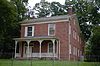 |
July 6, 1976 (#76001764) |
458 Market St. 35°17′12″N 84°45′17″W / 35.286667°N 84.754722°W | Charleston | |
| 17 | W.J. Hughes Business House |  |
June 10, 1975 (#75001735) |
70 Ocoee St. 35°09′34″N 84°52′33″W / 35.159444°N 84.875833°W | Cleveland | |
| 18 | Ocoee Street Historic District |  |
December 13, 1995 (#95001447) |
1455-1981 N. Ocoee St. 35°10′12″N 84°52′16″W / 35.17°N 84.871111°W | Cleveland | |
| 19 | Rattlesnake Springs |  |
September 5, 1975 (#75001734) |
Northeast of Cleveland off Dry Valley Rd. 35°14′40″N 84°46′22″W / 35.244444°N 84.772778°W | Cleveland | |
| 20 | Red Clay Council Ground |  |
September 14, 1972 (#72001229) |
13 miles south of Cleveland on Blue Springs Rd. 34°59′31″N 84°56′54″W / 34.991944°N 84.948333°W | Cleveland | Meeting ground for the Cherokee prior to the Cherokee Removal; now a state park |
| 21 | St. Luke's Episcopal Church |  |
April 12, 1982 (#82003954) |
Ocoee and Central Sts., NW. 35°09′40″N 84°52′29″W / 35.161111°N 84.874722°W | Cleveland | |
| 22 | Sanda Hosiery Mills | March 26, 2018 (#100002258) |
130-140 Edwards St. 35°09′28″N 84°52′20″W / 35.157823°N 84.872091°W | Cleveland | ||
| 23 | Tipton-Fillauer House |  |
December 8, 1980 (#80003782) |
63 Broad St., NW. 35°09′36″N 84°52′36″W / 35.16°N 84.876667°W | Cleveland | |
| 24 | U.S. Post Office |  |
June 30, 1983 (#83003023) |
155 Broad St., NW. 35°09′38″N 84°52′36″W / 35.160556°N 84.876667°W | Cleveland |
See also edit
Wikimedia Commons has media related to National Register of Historic Places in Bradley County, Tennessee.
References edit
- ^ The latitude and longitude information provided in this table was derived originally from the National Register Information System, which has been found to be fairly accurate for about 99% of listings. Some locations in this table may have been corrected to current GPS standards.
- ^ National Park Service, United States Department of the Interior, "National Register of Historic Places: Weekly List Actions", retrieved April 5, 2024.
- ^ Numbers represent an alphabetical ordering by significant words. Various colorings, defined here, differentiate National Historic Landmarks and historic districts from other NRHP buildings, structures, sites or objects.
- ^ "National Register Information System". National Register of Historic Places. National Park Service. April 24, 2008.
- ^ The eight-digit number below each date is the number assigned to each location in the National Register Information System database, which can be viewed by clicking the number.