
KNOWPIA
WELCOME TO KNOWPIA

National Register of Historic Places listings in Brown County, Minnesota 
Summary
This is a list of the National Register of Historic Places listings in Brown County, Minnesota. It is intended to be a complete list of the properties and districts on the National Register of Historic Places in Brown County, Minnesota, United States. The locations of National Register properties and districts for which the latitude and longitude coordinates are included below, may be seen in an online map.

There are 39 properties and districts listed on the National Register in the county. A supplementary list includes six additional sites that were formerly listed on the National Register.
This National Park Service list is complete through NPS recent listings posted April 12, 2024.[1]
Current listings edit
| [2] | Name on the Register | Image | Date listed[3] | Location | City or town | Description |
|---|---|---|---|---|---|---|
| 1 | Bendixon-Schmid House |  |
December 31, 1979 (#79001218) |
123 N. Marshall St. 44°14′27″N 94°58′32″W / 44.240833°N 94.975556°W | Springfield | 1894 Queen Anne house representative of Springfield's enclave of large, professional-class homes, owned successively by two notable figures in the city's development as an early commercial center.[4] |
| 2 | C. Berg's Hotel |  |
February 6, 2012 (#11001084) |
145 W. Main St. 44°17′49″N 94°43′27″W / 44.296964°N 94.724033°W | Sleepy Eye | 1899 hotel whose first-class accommodations, dining room, and display space for traveling salesmen were a key amenity in a regional milling and commerce center.[5] |
| 3 | Bjorneberg Garage | 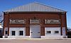 |
December 31, 1979 (#79001197) |
Broadway St. 44°08′52″N 94°29′38″W / 44.147804°N 94.493904°W | Hanska | Otherwise typical representative of the first automobile service stations—built c. 1919—made distinctive by its concrete bas-reliefs of motoring scenes.[6] |
| 4 | Boesch, Hummel, and Maltzahn Block |  |
December 31, 1979 (#79001201) |
6-12 N. Minnesota St. 44°18′49″N 94°27′33″W / 44.313725°N 94.459146°W | New Ulm | Most elaborate intact example—built in 1890—of the Main Street commercial blocks constructed in area towns around the turn of the 20th century.[7] Also a contributing property to the New Ulm Commercial Historic District.[8] |
| 5 | Chicago and North Western Depot |  |
June 25, 1992 (#92000822) |
Oak St., NW. 44°17′54″N 94°43′25″W / 44.298341°N 94.723523°W | Sleepy Eye | Large 1902 railway station, a major component of Sleepy Eye's transportation infrastructure in the first half of the 20th century when the city was a key railroad center in Southern Minnesota.[9] |
| 6 | Chicago and North Western Railroad Depot |  |
December 31, 1979 (#79001202) |
S. Valley St. 44°18′47″N 94°27′13″W / 44.312981°N 94.453505°W | New Ulm | Circa-1895 railway station attesting to the late-19th-century rail network that made New Ulm an important junction between the agricultural hinterland and urban markets.[10] |
| 7 | District No. 50 School | 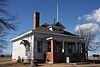 |
January 24, 2017 (#100000564) |
20837 U.S. 14 44°19′33″N 94°35′24″W / 44.325897°N 94.590133°W | Milford Township | Unusually intact 1912 one-room school built on a state-issued architectural plan. Also noted for representing efforts to provide nearby, locally-controlled education for rural Minnesota youth. Now the Milford Town Hall.[11] |
| 8 | Bernard Fesenmaier House |  |
December 31, 1979 (#79001203) |
426 N. State St. 44°19′01″N 94°27′58″W / 44.316807°N 94.466154°W | New Ulm | One of the most intact examples of New Ulm's late-19th-century German-style houses, built c. 1888 with polychrome brick.[12] |
| 9 | Flandrau State Park CCC/WPA/Rustic Style Historic Resources |  |
October 25, 1989 (#89001658) |
Off County Highway 13 southeast of New Ulm 44°17′32″N 94°28′13″W / 44.292111°N 94.470221°W | New Ulm | Park facilities with 24 contributing properties built 1934–42 with Germanic architectural elements, significant as examples of New Deal federal work relief, early Minnesota state park development, and National Park Service rustic design that uniquely harmonizes with local cultural context.[13] |
| 10 | Wanda Gág Childhood Home |  |
December 31, 1979 (#79001204) |
226 N. Washington St. 44°18′51″N 94°27′56″W / 44.3142°N 94.465622°W | New Ulm | Home from birth to age 20 of artist and author Wanda Gág (1893–1946), whose 1928 children's book Millions of Cats helped establish the picture book format.[14] Now a museum.[15] |
| 11 | Grand Hotel | 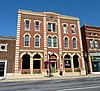 |
June 21, 1990 (#90000986) |
210 N. Minnesota St. 44°18′57″N 94°27′40″W / 44.315763°N 94.461034°W | New Ulm | 1876 Italianate hotel expanded in 1899, a key amenity in New Ulm's economic development and its finest example of commercial Victorian architecture.[16] Also a contributing property to the New Ulm Commercial Historic District.[8] |
| 12 | Hermann Monument |  |
October 2, 1973 (#73000965) |
Hermann Heights Park 44°18′26″N 94°28′22″W / 44.307098°N 94.472862°W | New Ulm | Landmark 120-foot (37 m) monument built 1887–89 by the Sons of Hermann society to honor the nation's German American heritage.[17] |
| 13 | Frederick W. Kiesling House |  |
February 23, 1972 (#72000674) |
220 N. Minnesota St. 44°18′58″N 94°27′40″W / 44.316168°N 94.461113°W | New Ulm | One of New Ulm's few remaining early houses—built in 1861—and a rare survivor of the Battles of New Ulm during the Dakota War of 1862.[18] Also a contributing property to the New Ulm Commercial Historic District.[8] |
| 14 | Kreitinger Garage |  |
December 31, 1979 (#79001219) |
1 N. Cass St. 44°14′21″N 94°58′27″W / 44.239167°N 94.974167°W | Springfield | c. 1911 car dealership with ornamental brickwork, a striking remnant of the early years of automobile use in Brown County.[19] |
| 15 | Lampert Lumber Company Line Yard | 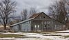 |
December 31, 1979 (#79001196) |
Center St. 44°19′30″N 94°36′19″W / 44.325°N 94.605278°W | Essig | Nominated as an extremely rare intact example of a small-town lumber store, built in 1919.[20] Demolished except for an outlying shed. |
| 16 | Liberal Union Hall | 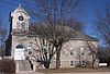 |
December 31, 1979 (#79001198) |
Broadway and Main Sts. 44°08′56″N 94°29′38″W / 44.149009°N 94.493907°W | Hanska | 1910 community center founded by the Unitarian separatists of the Nora Free Christian Church; noted as a long-serving local event venue and a symbol of a regionally unique religious group.[21] |
| 17 | Gov. John Lind House |  |
December 31, 1974 (#74001005) |
622 Center St. 44°18′45″N 94°27′43″W / 44.312363°N 94.46186°W | New Ulm | 1887 Queen Anne house of populist politician John Lind (1854–1930), four-term congressman and 14th governor of Minnesota.[22] |
| 18 | Melges Bakery | 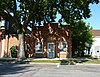 |
June 28, 1974 (#74001006) |
213 S. Minnesota St. 44°18′39″N 94°27′23″W / 44.310884°N 94.456435°W | New Ulm | One of New Ulm's few intact 19th-century commercial buildings, an 1865 butcher shop converted and expanded into a bakery in 1871.[23] |
| 19 | New Ulm Armory |  |
December 31, 1979 (#79001205) |
205 N. Broadway St. 44°18′53″N 94°27′47″W / 44.314589°N 94.462981°W | New Ulm | 1914 armory, leading example of the fortresslike style used in Minnesota before World War I, and home of one of the state's oldest National Guard companies, originating in 1871.[24] |
| 20 | New Ulm Commercial Historic District |  |
December 21, 2005 (#05001438) |
Roughly bounded by Minnesota St. between 1st St., S. and 3rd St., N. 44°18′51″N 94°27′36″W / 44.314299°N 94.459921°W | New Ulm | 4-block downtown district important in the economic development of south-central Minnesota, with 64 contributing properties—including retail, bank, and service buildings, plus theatres, meeting halls, and government offices—mostly built between the 1880s and 1948.[8] |
| 21 | New Ulm High School |  |
July 21, 2015 (#15000438) |
1 N. State St. 44°18′44″N 94°27′46″W / 44.3122°N 94.4628°W | New Ulm | 1915 school expanded in 1939 and 1956, reflecting the transformation of public high school education from the Progressive Era of the original section to the federal work relief of the 1930s and the Post–World War II baby boom. Later used as the New Ulm Junior High School.[25] |
| 22 | New Ulm Oil Company Service Station |  |
December 31, 1979 (#79001206) |
Broadway and Fifth Streets 44°19′04″N 94°27′54″W / 44.3178°N 94.4649°W | New Ulm | Fanciful 1926 gas station flanked by two towers, a rare surviving example of the eyecatching custom designs built throughout southern Minnesota by a local company as automobile use expanded in the 1920s.[26] |
| 23 | New Ulm Post Office |  |
April 28, 1970 (#70000287) |
2 N. Broadway 44°18′47″N 94°27′37″W / 44.3130°N 94.4603°W | New Ulm | Striking 1909 Renaissance Revival post office designed to reflect the heritage of New Ulm's original Germanic settlers.[27] Also a contributing property to the New Ulm Commercial Historic District.[8] Now houses the Brown County Historical Society.[28] |
| 24 | Nora Free Christian Church |  |
August 4, 1988 (#88001176) |
Minnesota Highway 257 44°08′36″N 94°28′53″W / 44.1432°N 94.4814°W | Hanska | 1883 church, 1906 parsonage, and cemetery associated with Norwegian intellectual Kristofer Janson (1841–1917) and his protégé Amandus Norman, who founded a liberal Unitarian minority among the state's conservative Lutheran Norwegian immigrants.[29] |
| 25 | Adolph C. Ochs House |  |
December 31, 1979 (#79001220) |
303 N. Marshall St. 44°14′32″N 94°58′33″W / 44.2423°N 94.9757°W | Springfield | 1911 Colonial Revival house of the founder of the A.C. Ochs Brick and Tile Company, a major local industry.[30] |
| 26 | Old Main, Dr. Martin Luther College |  |
December 31, 1979 (#79001208) |
College Heights, Martin Luther College campus 44°18′21″N 94°28′16″W / 44.3058°N 94.4712°W | New Ulm | 1884 original building of a Lutheran college; a leading example of Gothic Revival architecture in Minnesota and a distinctive symbol of local religious education.[31] |
| 27 | August Schell Brewing Company | 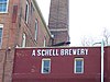 |
December 27, 1974 (#74001007) |
20th South St. 44°17′21″N 94°26′59″W / 44.2892°N 94.4497°W | New Ulm | Only surviving example of New Ulm's seven early breweries—established in 1860—with highly intact industrial buildings, residences, and gardens.[32] |
| 28 | Otto Schell House | 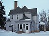 |
December 31, 1979 (#79001210) |
Point Lookout 44°17′29″N 94°26′50″W / 44.2915°N 94.4471°W | New Ulm | c. 1895 house of the second-generation manager of the August Schell Brewing Company, significant for its well-preserved Queen Anne architecture and association with an important local business.[33] |
| 29 | Shady Lane Stock Farm |  |
December 31, 1979 (#79001221) |
U.S. Route 14 44°15′04″N 94°56′48″W / 44.251°N 94.9466°W | Springfield | Farm with four structures built 1898–1913, significant for its regional influence in progressive farming (especially stock breeding), owner LaForest E. Potter's extensive agricultural association activity, and its prototype of the brick "A.C.O." silos erected throughout the Midwest.[34] |
| 30 | Sleepy Eye Milling Company |  |
February 8, 1991 (#91000038) |
Junction of 4th and Oak Sts., NE. 44°17′55″N 94°43′06″W / 44.2987°N 94.7183°W | Sleepy Eye | Flour milling complex with 20 contributing properties built 1901–1921, southern Minnesota's most complete example of an important agricultural processing industry.[35] |
| 31 | W. W. Smith House |  |
December 31, 1979 (#79001211) |
101 Linden St., SW. 44°17′34″N 94°43′24″W / 44.2928°N 94.7232°W | Sleepy Eye | c. 1901 house, Sleepy Eye's best-preserved example of the large residences erected by its professional class at the turn of the 20th century.[36] Now a bed and breakfast.[37] |
| 32 | South Broadway Historic District |  |
December 31, 1979 (#79001212) |
200–308 S. Broadway 44°18′39″N 94°27′33″W / 44.3108°N 94.4592°W | New Ulm | Locally distinctive row of eight brick houses constructed 1895–1906, and associated with a cross-section of New Ulm's professional class at the turn of the 20th century.[38] |
| 33 | South German Street Historic District |  |
December 31, 1979 (#79001217) |
110–312 S. German St. 44°18′43″N 94°27′21″W / 44.3119°N 94.4558°W | New Ulm | Eight houses mostly built 1884–1899, significant as Southwest Minnesota's best collection of large, late-19th-century residences and for their association with the era's business leaders in New Ulm.[39] |
| 34 | St. Michael's School and Convent |  |
December 31, 1979 (#79001213) |
500 N. State St. 44°19′02″N 94°27′59″W / 44.3171°N 94.4665°W | New Ulm | 1872 Italianate parochial building with a slightly later Second Empire height addition and 1898 Gothic Revival chapel, a rare example of early institutional architecture in Brown County.[40] |
| 35 | Synsteby Site |  |
May 12, 1975 (#75000976) |
Address restricted[41] 44°06′59″N 94°32′53″W / 44.1164°N 94.5480°W | Hanska | Archaeological site unique in Minnesota for exhibiting four distinct cultural components: two separate Woodland period occupations, a Mississippian culture phase, and an 1863 Euro-American fort.[42] Now preserved within Lake Hanska County Park.[43] |
| 36 | Thormodson Barn |  |
December 31, 1979 (#79001199) |
Off Minnesota Highway 257 44°07′50″N 94°26′27″W / 44.1306°N 94.4409°W | Hanska | 1912 hexadecagonal barn, Brown County's only known example of the round barn fad and one of the few in southwestern Minnesota.[44] |
| 37 | Turner Hall | 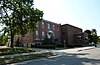 |
December 31, 1979 (#79001215) |
102 S. State St. 44°18′37″N 94°27′39″W / 44.3103°N 94.4608°W | New Ulm | 1873 gymnasium and meeting hall of the Turners group that helped settle New Ulm in 1856; a symbol of the city's founding, its German-American heritage, and this once-common immigrant organization.[45] |
| 38 | The Way of the Cross |  |
November 2, 2020 (#100004756) |
1500 Fifth Street North 44°18′42″N 94°28′39″W / 44.3117°N 94.4774°W | New Ulm | Stations of the Cross built from 1903-04 (renovations in 2004 and 2018), featuring the traditional 14 station that include statues imported from Bavaria, along a 700-foot brick path to a chapel dedicated to the Mother of Sorrows; possibly the first Stations of the Cross listed on the NRHP.[46] |
| 39 | Winona and St. Peter Freight Depot | 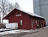 |
December 31, 1979 (#79001216) |
Oak St., NE. 44°17′55″N 94°43′17″W / 44.2986°N 94.7215°W | Sleepy Eye | c. 1887 Winona and St. Peter Railroad depot, oldest surviving building associated with the transformative first years of rail access in Brown County.[47] |
Former listings edit
| [2] | Name on the Register | Image | Date listed | Date removed | Location | City or town | Description |
|---|---|---|---|---|---|---|---|
| 1 | Chicago and North Western Section House | 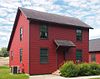 |
December 31, 1979 (#79001195) | March 28, 1990 | Railroad and Brown Sts. (original address) Current coordinates are 44°04′29″N 95°39′54″W / 44.0746°N 95.6651°W | Comfrey | c. 1899 section house, nominated as Brown County's last remaining structure associated with its later granger rail lines.[48] Moved to End-O-Line Railroad Park in Currie, Minnesota in 1988.[49] |
| 2 | Cobden Jail |  |
December 31, 1979 (#79001194) | August 8, 1991 | 2nd Street 44°17′11″N 94°51′01″W / 44.2864°N 94.8504°W | Cobden | Built c. 1900.[48] Significantly altered in 1989.[50] |
| 3 | New Ulm Roller Mill Complex | 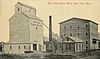 |
December 31, 1979 (#79001207) | June 25, 1986 | 222 1st South St. | New Ulm | Flour mill complex dating to 1910.[51] Burned down in the early 1980s.[50] |
| 4 | Ruemke Mercantile Store | December 31, 1979 (#79001209) | May 4, 1984 | 226 N. Minnesota | New Ulm | 1895 Queen Anne commercial building.[52] Demolished in 1981.[50] | |
| 5 | Tivoli Gardens | December 31, 1979 (#79001214) | May 15, 1987 | 313 1st North St. | New Ulm | 1885 restaurant.[53] Demolished in 1985.[50] | |
| 6 | Twente Farm Elevator and Granary | December 31, 1979 (#79001200) | September 25, 1987 | off Co. Rd. 16 | Albin Township | 1885 agricultural buildings.[54] Demolished in 1986.[50] |
See also edit
References edit
- ^ National Park Service, United States Department of the Interior, "National Register of Historic Places: Weekly List Actions", retrieved April 12, 2024.
- ^ a b Numbers represent an alphabetical ordering by significant words. Various colorings, defined here, differentiate National Historic Landmarks and historic districts from other NRHP buildings, structures, sites or objects.
- ^ The eight-digit number below each date is the number assigned to each location in the National Register Information System database, which can be viewed by clicking the number.
- ^ Gimmestad, Dennis A. (January 1979). "Minnesota Historic Properties Inventory Form: Bendixon-Schmid House". National Park Service. Retrieved 2016-01-10.
- ^ Hoisington, Daniel J. "National Register of Historic Places Registration Form: C. Berg's Hotel" (PDF). National Park Service. Retrieved 2016-01-10.
- ^ Gimmestad, Dennis (January 1979). "Minnesota Historic Properties Inventory Form: Bjorneberg Garage". National Park Service. Retrieved 2016-01-10.
- ^ Gimmestad, Dennis (January 1979). "Minnesota Historic Properties Inventory Form: Boesch, Hummel, and Maltzahn Block". National Park Service. Retrieved 2016-01-10.
- ^ a b c d e Hoisington, Daniel J. (2005-05-01). "National Register of Historic Places Registration Form: New Ulm Commercial Historic District". National Park Service. Retrieved 2016-01-01.
- ^ Roise, Charlene K.; Robert M. Hybben (September 1991). "National Register of Historic Places Registration Form: Chicago and North Western Depot". National Park Service. Retrieved 2016-01-10.
- ^ Gimmestad, Dennis (January 1979). "Minnesota Historic Properties Inventory Form: Chicago & North Western RR Depot" (Document). National Park Service.
- ^ Dove, Deborah; Daniel J. Hoisington (2016-05-10). "National Register of Historic Places Registration Form: District No. 50 School" (PDF). National Park Service. Retrieved 2017-02-19.
{{cite journal}}: Cite journal requires|journal=(help) - ^ Gimmestad, Dennis A. (January 1979). "Minnesota Historic Properties Inventory Form: Fesenmaier, Bernard, House". National Park Service. Retrieved 2016-01-10.
- ^ Anderson, Rolf T. (1988-09-08). "National Register of Historic Places Registration Form: Flandrau State Park CCC/WPA/Rustic Style Historic Resources". National Park Service. Retrieved 2016-01-03.
- ^ Gimmestad, Dennis (January 1979). "Minnesota Historic Properties Inventory Form: Gag, Wanda, Childhood House". National Park Service. Retrieved 2016-01-03.
- ^ "Wanda Gág House". Wanda Gag House. 2016. Retrieved 2016-01-03.
- ^ Koop, Michael (January 1989). "National Register of Historic Places Registration Form: Grand Hotel". National Park Service. Retrieved 2016-01-03.
- ^ Harren, Henry M. (1973-09-12). "National Register of Historic Places Inventory – Nomination Form: Hermann Monument". National Park Service. Retrieved 2016-01-03.
- ^ Bredeson, Tom (1971-01-14). "National Register of Historic Places Inventory – Nomination Form: Kiesling House". National Park Service. Retrieved 2016-01-03.
- ^ Gimmestad, Dennis (January 1979). "Minnesota Historic Properties Inventory Form: Kreitinger Garage". National Park Service. Retrieved 2016-01-03.
- ^ Gimmestad, Dennis (January 1979). "Minnesota Historic Properties Inventory Form: Lambert Lumber Company Line Yard". National Park Service. Retrieved 2016-01-03.
- ^ Gimmestad, Dennis (January 1979). "Minnesota Historic Properties Inventory Form: Liberal Union Hall". National Park Service. Retrieved 2016-01-03.
- ^ Van Brocklin, Lynne; Charles W. Nelson (1974-08-09). "National Register of Historic Places Inventory – Nomination Form: Lind, Governor John, House". National Park Service. Retrieved 2016-01-03.
- ^ Harren, Henry M. (1975-03-27). "National Register of Historic Places Inventory – Nomination Form: Melges Bakery". National Park Service. Retrieved 2016-01-01.
- ^ Gimmestad, Dennis (January 1979). "Minnesota Historic Properties Inventory Form: New Ulm Armory". National Park Service. Retrieved 2016-01-01.
- ^ Hoisington, Daniel J. (2015-02-15). "National Register of Historic Places Registration Form: New Ulm High School" (PDF). National Park Service. Retrieved 2015-12-29.
- ^ Gimmestad, Dennis (January 1979). "Minnesota Historic Properties Inventory Form: New Ulm Oil Company Service Station". National Park Service. Retrieved 2015-12-29.
- ^ Cavin, Brooks (1970-03-18). "National Register of Historic Places Inventory – Nomination Form: Federal Post Office Building". National Park Service. Retrieved 2015-12-29.
- ^ "Contact Us". Brown County Historical Society. Retrieved 2018-01-30.
- ^ Granger, Susan (March 1986). "National Register of Historic Places Inventory—Nomination Form: Nora Free Christian Church". National Park Service. Retrieved 2015-12-29.
- ^ Gimmestad, Dennis (January 1979). "Minnesota Historic Properties Inventory Form: Ochs, A.C., House". National Park Service. Retrieved 2015-12-29.
- ^ Gimmestad, Dennis (January 1979). "Minnesota Historic Properties Inventory Form: Old Main, Dr. Martin Luther College". National Park Service. Retrieved 2015-12-29.
- ^ Nelson, Charles W. (1974-11-01). "National Register of Historic Places Inventory – Nomination Form: Schell, August, Brewing Company". National Park Service. Retrieved 2015-12-28.
- ^ Gimmestad, Dennis A. (January 1979). "Minnesota Historic Properties Inventory Form: Schell, Otto, House". National Park Service. Retrieved 2015-12-28.
- ^ Gimmestad, Dennis A. (January 1979). "Minnesota Historic Properties Inventory Form: Shady Lane Stock Farm". National Park Service. Retrieved 2015-12-28.
- ^ Koop, Michael (February 1989). "National Register of Historic Places Registration Form: Sleepy Eye Milling Company". National Park Service. Retrieved 2015-12-28.
- ^ Gimmestad, Dennis (January 1979). "Minnesota Historic Properties Inventory Form: Smith, W.W., House". National Park Service. Retrieved 2015-12-28.
- ^ "The W.W. Smith Inn Bed and Breakfast". W.W. Smith Inn, Inc. Retrieved 2016-03-13.
- ^ Gimmestad, Dennis (January 1979). "Minnesota Historic Properties Inventory Form: South Broadway Historic District". National Park Service. Retrieved 2015-12-28.
- ^ Gimmestad, Dennis (January 1979). "Minnesota Historic Properties Inventory Form: South German Street Historic District". National Park Service. Retrieved 2015-12-28.
- ^ Gimmestad, Dennis (January 1979). "Minnesota Historic Properties Inventory Form: St. Michael's School and Convent". National Park Service. Retrieved 2015-12-19.
- ^ Federal and state laws and practices restrict general public access to information regarding the specific location of this resource. In some cases, this is to protect archeological sites from vandalism, while in other cases it is restricted at the request of the owner. See: Knoerl, John; Miller, Diane; Shrimpton, Rebecca H. (1990), Guidelines for Restricting Information about Historic and Prehistoric Resources, National Register Bulletin, National Park Service, U.S. Department of the Interior, OCLC 20706997.
- ^ George, Douglas (1975-03-17). "National Register of Historic Places Inventory -- Nomination Form: Synsteby Site (21BW1)" (Document). National Park Service.
- ^ "Lake Hanska Park Overview". Brown County. 2011. Retrieved 2012-11-14.
- ^ Gimmestad, Dennis (January 1979). "Minnesota Historic Properties Inventory Form: Thormodson Barn". National Park Service. Retrieved 2015-12-19.
- ^ Gimmestad, Dennis (January 1979). "Minnesota Historic Properties Inventory Form: Turner Hall" (Document). National Park Service.
- ^ Clay Schuldt, Way of the Cross named to National Register of Historic Places, The Journal, December 16, 2020.
- ^ Gimmestad, Dennis (January 1979). "Minnesota Historic Properties Inventory Form: Winona and St. Peter Freight Depot". National Park Service. Retrieved 2015-12-19.
- ^ a b Gimmestad, Dennis A. (January 1979). "Brown County Multiple Resource Area". National Park Service. Retrieved 2013-08-26.
{{cite journal}}: Cite journal requires|journal=(help) - ^ Weber, Laura (Fall 1997). "Wins and Losses: The National Register of Historic Places in Minnesota" (PDF). Minnesota History: 302–319.
- ^ a b c d e Nord, Mary Ann (2003). The National Register of Historic Places in Minnesota. Minnesota Historical Society. ISBN 0-87351-448-3.
- ^ "New Ulm Roller Mill Complex (removed)". Minnesota National Register Properties Database. Minnesota Historical Society. 2009. Retrieved 2013-08-26.
- ^ "Ruemke Mercantile Store (removed)". Minnesota National Register Properties Database. Minnesota Historical Society. 2009. Retrieved 2013-08-26.
- ^ "Tivoli Gardens (removed)". Minnesota National Register Properties Database. Minnesota Historical Society. 2009. Retrieved 2013-08-26.
- ^ "Twente Farm Elevator and Granary (removed)". Minnesota National Register Properties Database. Minnesota Historical Society. 2009. Retrieved 2013-08-26.
External links edit
Wikimedia Commons has media related to National Register of Historic Places in Brown County, Minnesota.
- Minnesota National Register Properties Database—Minnesota Historical Society