
KNOWPIA
WELCOME TO KNOWPIA

National Register of Historic Places listings in Buena Vista County, Iowa 
Summary
This is a list of the National Register of Historic Places listings in Buena Vista County, Iowa.

This is intended to be a complete list of the properties and districts on the National Register of Historic Places in Buena Vista County, Iowa, United States. Latitude and longitude coordinates are provided for many National Register properties and districts; these locations may be seen together in a map.[1]
There are 10 properties and districts listed on the National Register in the county.
This National Park Service list is complete through NPS recent listings posted April 12, 2024.[2]
Current listings edit
| [3] | Name on the Register[4] | Image | Date listed[5] | Location | City or town | Description |
|---|---|---|---|---|---|---|
| 1 | Jesse J. and Mary F. Allee House |  |
March 26, 1992 (#92000271) |
2020 640th St. 42°35′21″N 95°00′35″W / 42.5893°N 95.00975°W | Newell | Historic home built in 1891. |
| 2 | Brooke Creek Bridge | June 25, 1998 (#98000754) |
470th St. over Brooke Creek 42°50′11″N 95°17′08″W / 42.836389°N 95.285556°W | Sioux Rapids | ||
| 3 | Chan-Ya-Ta Site | 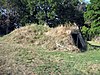 |
November 21, 1978 (#78001209) |
Left bank of Brooke Creek, southwest of Linn Grove[6] 42°52′22″N 95°18′11″W / 42.872778°N 95.303056°W | Linn Grove | |
| 4 | Chicago, Milwaukee and Pacific Railroad-Albert City Station |  |
October 22, 1976 (#76000737) |
212 N. 2nd St. 42°46′53″N 94°56′54″W / 42.781389°N 94.948333°W | Albert City | |
| 5 | Danish Lutheran Church | November 18, 2011 (#11000814) |
113 W. 4th St. 42°40′18″N 95°18′16″W / 42.671667°N 95.304444°W | Alta | ||
| 6 | Harker House |  |
December 6, 1990 (#90001855) |
328 Lake Ave. 42°38′27″N 95°12′04″W / 42.640833°N 95.201111°W | Storm Lake | Historic home built in 1875. |
| 7 | Illinois Central Passenger Depot-Storm Lake |  |
September 6, 1990 (#90001300) |
South of W. Railroad St., between Lake and Michigan Aves. 42°38′35″N 95°12′06″W / 42.643056°N 95.201667°W | Storm Lake | |
| 8 | Sioux Theatre | February 21, 2012 (#12000030) |
218 Main St. 42°53′36″N 95°08′59″W / 42.89322°N 95.149811°W | Sioux Rapids | Movie Theaters of Iowa Multiple Property Submission | |
| 9 | Storm Lake High School | January 17, 2017 (#100000485) |
310 Cayuga St. 42°38′24″N 95°11′55″W / 42.640046°N 95.198560°W | Storm Lake | ||
| 10 | Storm Lake Public Library |  |
May 23, 1983 (#83000346) |
E. 5th and Erie Sts. 42°38′39″N 95°11′57″W / 42.6442°N 95.1993°W | Storm Lake | Carnegie-funded library building (no longer used as public library). |
See also edit
Wikimedia Commons has media related to National Register of Historic Places in Buena Vista County, Iowa.
- List of National Historic Landmarks in Iowa
- National Register of Historic Places listings in Iowa
- Listings in neighboring counties: Cherokee, Clay, Pocahontas, Sac
References edit
- ^ The latitude and longitude information provided in this table was derived originally from the National Register Information System, which has been found to be fairly accurate for about 99% of listings. Some locations in this table may have been corrected to current GPS standards.
- ^ National Park Service, United States Department of the Interior, "National Register of Historic Places: Weekly List Actions", retrieved April 12, 2024.
- ^ Numbers represent an alphabetical ordering by significant words. Various colorings, defined here, differentiate National Historic Landmarks and historic districts from other NRHP buildings, structures, sites or objects.
- ^ "National Register Information System". National Register of Historic Places. National Park Service. July 9, 2010.
- ^ The eight-digit number below each date is the number assigned to each location in the National Register Information System database, which can be viewed by clicking the number.
- ^ Vis, Robert B., and Dale R. Henning. "A Local Sequence for Mill Creek Sites in the Little Sioux River Valley". Plains Anthropologist 14.46 (1969): 253-271: 254.