
KNOWPIA
WELCOME TO KNOWPIA

National Register of Historic Places listings in Calhoun County, Illinois 
Summary
This is a list of the National Register of Historic Places listings in Calhoun County, Illinois.

This is intended to be a complete list of the properties and districts on the National Register of Historic Places in Calhoun County, Illinois, United States. Latitude and longitude coordinates are provided for many National Register properties and districts; these locations may be seen together in a map.[1]
There are 7 properties and districts listed on the National Register in the county, including one former National Historic Landmark.
This National Park Service list is complete through NPS recent listings posted April 12, 2024.[2]
Current listings edit
| [3] | Name on the Register | Image | Date listed[4] | Location | City or town | Description |
|---|---|---|---|---|---|---|
| 1 | Brussels Historic District |  |
August 6, 1998 (#98000981) |
Roughly along Main and Community Sts. 38°56′59″N 90°35′13″W / 38.949722°N 90.586944°W | Brussels | |
| 2 | Golden Eagle-Toppmeyer Site |  |
June 14, 1979 (#79000816) |
Western side of Quarry Rd., south of Illinois River Rd.[5] 38°54′55″N 90°31′13″W / 38.91527°N 90.52027°W | Brussels | |
| 3 | Goldenrod |  |
December 24, 1967 (#67000029) |
Kampsville riverfront[6] 39°20′27″N 90°37′10″W / 39.340833°N 90.619444°W | Kampsville | Burned in 2017 and remains subsequently scrapped; NHL designation withdrawn in 2023. |
| 4 | Kamp Mound Site |  |
August 24, 1978 (#78001114) |
Illinois Route 100, north of Kampsville[7] 39°19′56″N 90°37′15″W / 39.33222°N 90.62083°W | Kampsville | |
| 5 | Kamp Store | 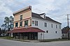 |
February 4, 1994 (#94000027) |
Northeastern corner of the junction of Oak and Broadway 39°17′54″N 90°36′37″W / 39.298333°N 90.610278°W | Kampsville | |
| 6 | Michael Klunk Farmstead |  |
June 23, 1982 (#82002518) |
Crater Creek Rd., south of Kampsville[8] 39°15′23″N 90°38′14″W / 39.256389°N 90.637222°W | Michael | |
| 7 | Schudel No. 2 Site |  |
June 15, 1979 (#79000817) |
200N, west of Mississippi River Rd.[9] 39°09′49″N 90°41′36″W / 39.16361°N 90.69333°W | Hamburg |
See also edit
Wikimedia Commons has media related to National Register of Historic Places in Calhoun County, Illinois.
References edit
- ^ The latitude and longitude information provided in this table was derived originally from the National Register Information System, which has been found to be fairly accurate for about 99% of listings. Some locations in this table may have been corrected to current GPS standards.
- ^ National Park Service, United States Department of the Interior, "National Register of Historic Places: Weekly List Actions", retrieved April 12, 2024.
- ^ Numbers represent an alphabetical ordering by significant words. Various colorings, defined here, differentiate National Historic Landmarks and historic districts from other NRHP buildings, structures, sites or objects.
- ^ The eight-digit number below each date is the number assigned to each location in the National Register Information System database, which can be viewed by clicking the number.
- ^ Maruszak, Kathleen. National Register of Historic Places Inventory/Nomination: Golden Eagle-Toppmeyer Site. National Park Service, 1979-01, 5.
- ^ Schankman, Paul. "Goldenrod Showboat Up For Auction", KTVI, 2013-05-17. Accessed 2013-08-29.
- ^ Maruszak, Kathleen. National Register of Historic Places Inventory/Nomination: Kamp Mound Site. National Park Service, 1977-07, 4.
- ^ Ward, Michael, and Keith A. Sculle. National Register of Historic Places Inventory/Nomination: Michael Klunk Farmstead. National Park Service, n.d., 7.
- ^ Maruszak, Kathleen A. National Register of Historic Places Inventory/Nomination: Schudel No. 2 Site. National Park Service, 1979-01, 2.