
KNOWPIA
WELCOME TO KNOWPIA

National Register of Historic Places listings in Caroline County, Virginia 
Summary
This is a list of the National Register of Historic Places listings in Caroline County, Virginia.

This is intended to be a complete list of the properties and districts on the National Register of Historic Places in Caroline County, Virginia, United States. The locations of National Register properties and districts for which the latitude and longitude coordinates are included below, may be seen in an online map.[1]
There are 22 properties and districts listed on the National Register in the county, including 1 National Historic Landmark.
This National Park Service list is complete through NPS recent listings posted April 12, 2024.[2]
Current listings edit
| [3] | Name on the Register[4] | Image | Date listed[5] | Location | City or town | Description |
|---|---|---|---|---|---|---|
| 1 | Auburn |  |
May 3, 2006 (#06000342) |
320 N. Main St. 38°03′26″N 77°21′19″W / 38.057222°N 77.355278°W | Bowling Green | |
| 2 | Bowling Green Historic District |  |
May 22, 2003 (#03000439) |
Roughly along and bounded by U.S. Route 301, Broadus Ave., Lakewood Rd., N. Main St., and Paige Rd. 38°03′00″N 77°20′48″W / 38.050000°N 77.346667°W | Bowling Green | |
| 3 | Camden |  |
November 12, 1969 (#69000228) |
Northern end of Camden Rd.[6] 38°09′48″N 77°09′41″W / 38.163333°N 77.161389°W | Port Royal | |
| 4 | Caroline County Courthouse |  |
May 25, 1973 (#73001999) |
Main St. and Courthouse Ln. 38°03′04″N 77°20′49″W / 38.051111°N 77.346944°W | Bowling Green | |
| 5 | Edge Hill |  |
February 10, 1983 (#83003264) |
West of Woodford on Edgehill Academy Rd. 38°07′05″N 77°27′35″W / 38.118056°N 77.459722°W | Woodford | |
| 6 | Gay Mont | 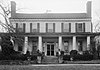 |
May 19, 1972 (#72001387) |
Off U.S. Route 17 near its junction with U.S. Route 301 38°10′26″N 77°13′49″W / 38.173889°N 77.230278°W | Port Royal | |
| 7 | Grace Episcopal Church |  |
January 14, 2019 (#100003313) |
4565 Fredericksburg Turnpike 38°11′56″N 77°23′17″W / 38.198889°N 77.388056°W | Corbin | |
| 8 | Green Falls | 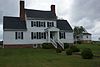 |
May 23, 1997 (#97000485) |
Junction of Old Stage Rd. and the Mattaponi Trail 37°57′13″N 77°18′39″W / 37.953611°N 77.310972°W | Bowling Green | |
| 9 | The Grove |  |
May 21, 2009 (#09000333) |
33115 Mount Gideon Rd. 37°48′34″N 77°22′06″W / 37.809306°N 77.368333°W | Hanover | |
| 10 | Hazelwood |  |
January 11, 1974 (#74002111) |
Off Hazelwood Rd.[7] 38°11′07″N 77°13′52″W / 38.185278°N 77.231111°W | Port Royal | |
| 11 | Jericho School |  |
February 11, 2004 (#04000041) |
Jericho Rd. 37°55′45″N 77°30′42″W / 37.929167°N 77.511667°W | Ruther Glen | |
| 12 | The Meadow Historic District |  |
May 26, 2015 (#15000276) |
13111 Dawn Boulevard 37°51′08″N 77°25′14″W / 37.852222°N 77.420556°W | Doswell | |
| 13 | Moss Neck Manor |  |
January 27, 1999 (#99000069) |
Burma Rd. on the southern side of the Rappahannock River 38°12′31″N 77°19′32″W / 38.208611°N 77.325556°W | Rappahannock Academy | |
| 14 | Mount Gideon | February 27, 2020 (#100005012) |
33295 Mt. Gideon Rd. 37°48′12″N 77°22′03″W / 37.8034°N 77.3674°W | Hanover | ||
| 15 | Old Jail of Caroline County |  |
February 25, 2020 (#100005008) |
119 North Main St. 38°03′03″N 77°20′48″W / 38.050750°N 77.346667°W | Bowling Green | |
| 16 | Old Mansion |  |
November 12, 1969 (#69000227) |
South of the junction of U.S. Route 301 and State Route 207 38°02′39″N 77°20′51″W / 38.044028°N 77.347500°W | Bowling Green | |
| 17 | Port Royal Historic District |  |
February 16, 1970 (#70000786) |
Roughly bounded by the Rappahannock River, Roys Run, U.S. Route 17, and Goldenville Creek 38°10′10″N 77°11′29″W / 38.169444°N 77.191389°W | Port Royal | |
| 18 | Prospect Hill |  |
December 12, 1976 (#76002096) |
Southeast of Fredericksburg off U.S. Route 17 38°13′32″N 77°21′55″W / 38.225556°N 77.365278°W | Fredericksburg | |
| 19 | Riverview | 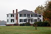 |
July 29, 1994 (#94000792) |
Water St. 38°10′15″N 77°11′16″W / 38.170972°N 77.187778°W | Port Royal | |
| 20 | Santee | 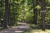 |
May 7, 1979 (#79003034) |
Off Pepmeier Hill Rd. 38°13′10″N 77°21′37″W / 38.219444°N 77.360278°W | Corbin | |
| 21 | Spring Grove |  |
December 12, 1976 (#76002097) |
1.5 miles (2.4 km) southwest of Oak Corner along Mattaponi Trail[8] 37°58′41″N 77°19′55″W / 37.978056°N 77.331944°W | Oak Corner | |
| 22 | Townfield | 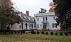 |
July 29, 1994 (#94000791) |
Water St. 38°10′13″N 77°11′17″W / 38.170278°N 77.188056°W | Port Royal |
See also edit
Wikimedia Commons has media related to National Register of Historic Places in Caroline County, Virginia.
References edit
- ^ The latitude and longitude information provided in this table was derived originally from the National Register Information System, which has been found to be fairly accurate for about 99% of listings. Some locations in this table may have been corrected to current GPS standards.
- ^ National Park Service, United States Department of the Interior, "National Register of Historic Places: Weekly List Actions", retrieved April 12, 2024.
- ^ Numbers represent an alphabetical ordering by significant words. Various colorings, defined here, differentiate National Historic Landmarks and historic districts from other NRHP buildings, structures, sites or objects.
- ^ "National Register Information System". National Register of Historic Places. National Park Service. April 24, 2008.
- ^ The eight-digit number below each date is the number assigned to each location in the National Register Information System database, which can be viewed by clicking the number.
- ^ Division of Historic Landmarks Staff. National Register of Historic Places Inventory/Nomination: Camden. National Park Service, 1969-07-29, 8.
- ^ "Hazelwood". Geographic Names Information System. United States Geological Survey, United States Department of the Interior.
- ^ Division of Historic Landmarks Staff. National Register of Historic Places Inventory/Nomination: Spring Grove. National Park Service, 1976-07, 8.