


Summary
This is a list of the National Register of Historic Places listings in Charleston County, South Carolina.

This is intended to be a complete list of the properties and districts on the National Register of Historic Places in Charleston County, South Carolina, United States. The locations of National Register properties and districts for which the latitude and longitude coordinates are included below, may be seen in an online map.[1]
There are 205 properties and districts listed on the National Register in the county, including 43 National Historic Landmarks. The city of Charleston is the location of 104 of these properties and districts, including 34 of the National Historic Landmarks; they are listed separately, while 104 properties and districts in the remaining parts of the county, including 9 National Historic Landmarks, are listed here. Another 5 properties in Charleston County outside Charleston were once listed but have been removed. Three properties and districts — the Ashley River Historic District, Ashley River Road, and the Secessionville Historic District — are split between the city and the other parts of the county, and are thus included on both lists.
This National Park Service list is complete through NPS recent listings posted April 12, 2024.[2]
Current listings edit
| [3] | Name on the Register[4] | Image | Date listed[5] | Location | City or town | Description |
|---|---|---|---|---|---|---|
| 1 | Ashley Hall Plantation |  |
June 5, 1975 (#75001691) |
Address restricted[6] | West Ashley | |
| 2 | Ashley River Historic District |  |
September 12, 1994 (#93001514) |
Roughly along the Ashley River from just east of South Carolina Highway 165, near Watson Hill (North Charleston), to the Seaboard Coast Line Railroad bridge 32°53′58″N 80°07′00″W / 32.8994°N 80.1167°W | North Charleston | Extends into Charleston and Dorchester County |
| 3 | Ashley River Road |  |
November 21, 1983 (#83003831) |
South Carolina Highway 61 between Church Creek and South Carolina Highway 165 32°53′43″N 80°08′08″W / 32.8953°N 80.1356°W | Summerville | Extends into Charleston and Dorchester County |
| 4 | Atlanticville Historic District | September 6, 2007 (#07000927) |
Middle St., Jasper Boulevard, and Myrtle Ave. between Stations 22½ and 26 32°45′55″N 79°49′57″W / 32.7653°N 79.8325°W | Sullivan's Island | ||
| 5 | Auld Mound | October 15, 1970 (#70000583) |
Address Restricted | Mount Pleasant | ||
| 6 | Alexander Bache U.S. Coast Survey Line |  |
October 5, 2007 (#07001082) |
8377 State Cabin Rd. 32°30′20″N 80°18′37″W / 32.5056°N 80.3103°W | Edisto Island | |
| 7 | Bailey's Store |  |
November 28, 1986 (#86003204) |
1444 South Carolina Highway 174 32°33′36″N 80°16′47″W / 32.56009°N 80.27961°W | Edisto Island | Now occupied by With These Hands Gallery.[7] |
| 8 | Barnwell House | November 25, 1980 (#80003657) |
South of Charleston 32°41′54″N 80°24′22″W / 32.6983°N 80.4061°W | Adams Run | ||
| 9 | Bass Pond Site | April 24, 1979 (#79002379) |
Address Restricted | Kiawah Island | ||
| 10 | Battery Gadsden |  |
June 25, 1974 (#74001842) |
2017 Ion Ave. 32°45′36″N 79°50′23″W / 32.76°N 79.8397°W | Sullivan's Island | Now houses the Edgar Allan Poe Branch of the Charleston County Library |
| 11 | Battery Thomson |  |
June 25, 1974 (#74001843) |
2013 Ion Ave. 32°45′33″N 79°50′28″W / 32.7592°N 79.8411°W | Sullivan's Island | |
| 12 | Bethel African Methodist Episcopal Church |  |
June 22, 2004 (#04000651) |
369 Drayton St. 33°05′21″N 79°27′26″W / 33.0893°N 79.4571°W | McClellanville | |
| 13 | Bleak Hall Plantation Outbuildings | 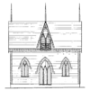 |
March 7, 1973 (#73001698) |
4 miles southeast of Edisto Island off South Carolina Highway 174 32°33′10″N 80°14′05″W / 32.5528°N 80.2347°W | Edisto Island | |
| 14 | Brick House Ruin |  |
April 15, 1970 (#70000580) |
South of Edisto Island 32°36′05″N 80°19′32″W / 32.6014°N 80.3256°W | Edisto Island | |
| 15 | Brooklands Plantation |  |
May 5, 1987 (#86003198) |
Off Laurel Hill Rd. on Scanawah Island 32°34′19″N 80°21′19″W / 32.5719°N 80.3553°W | Edisto Island | |
| 16 | Buzzard's Island Site | October 15, 1970 (#70000584) |
Address Restricted | Mount Pleasant | ||
| 17 | Cape Romain Lighthouses |  |
November 12, 1981 (#81000563) |
Southeast of McClellanville on Lighthouse Island 33°01′06″N 79°22′27″W / 33.0183°N 79.3742°W | McClellanville | |
| 18 | Cassina Point |  |
November 28, 1986 (#86003210) |
1642 Clark Road, Edisto, South Carolina 32°35′29″N 80°15′03″W / 32.5914°N 80.2508°W | Edisto Island | |
| 19 | Charleston Naval Hospital | January 25, 2021 (#100006050) |
3600 Rivers Ave. 32°51′27″N 79°58′46″W / 32.8576°N 79.9794°W | North Charleston | ||
| 20 | Charleston Naval Hospital Historic District | 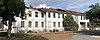 |
October 22, 2010 (#10000851) |
Former Charleston Navy Base including parts of Turnbull Avenue, Hobby Street, Avenues F-I, Truxton Avenue, and Marine Avenue[8] 32°51′51″N 79°58′02″W / 32.8642°N 79.9672°W | North Charleston | |
| 21 | Charleston Navy Yard Historic District | 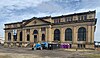 |
August 9, 2006 (#06000699) |
Roughly bounded by 1st St., Hobson Ave., Ave. D, 4th and 5th Sts., and the drydocks between 1st and 13th Sts. 32°51′43″N 79°57′46″W / 32.8619°N 79.9628°W | North Charleston | |
| 22 | Charleston Navy Yard Officers' Quarters Historic District | 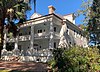 |
March 2, 2007 (#07000100) |
Turnbull Ave., Everglades Dr., Navy Way, and portions of Hobson Ave. and Blackstop Dr. 32°52′08″N 79°58′09″W / 32.8689°N 79.9692°W | North Charleston | |
| 23 | Christ Church |  |
November 27, 1972 (#72001201) |
2304 Highway 17N[9] 32°50′38″N 79°48′50″W / 32.8439°N 79.8139°W | Mount Pleasant | |
| 24 | Cook's Old Field Cemetery | May 9, 2003 (#01000679) |
0.5 miles north of Rifle Range Rd. 32°50′20″N 79°48′13″W / 32.8389°N 79.8036°W | Mount Pleasant | ||
| 25 | Crawford's Plantation House |  |
June 8, 1993 (#93000475) |
8202 Oyster Factory Rd. 32°32′15″N 80°18′16″W / 32.5375°N 80.3044°W | Edisto Island | |
| 26 | Edisto Island Baptist Church |  |
April 1, 1982 (#82003839) |
1644 South Carolina Highway 174[10] 32°34′22″N 80°17′03″W / 32.5728°N 80.2842°W | Edisto Island | |
| 27 | Edisto Island Presbyterian Church |  |
June 24, 1971 (#71000754) |
1.9 miles north of Edisto Island on South Carolina Highway 174 32°34′44″N 80°17′49″W / 32.5789°N 80.2969°W | Edisto Island | |
| 28 | Engineering-Management Building |  |
September 4, 2020 (#100005002) |
2260 Noisette Blvd. 32°51′55″N 79°58′16″W / 32.8654°N 79.9711°W | North Charleston | |
| 29 | Fairfield Plantation |  |
July 25, 1974 (#74001838) |
North of McClellanville 33°10′58″N 79°24′18″W / 33.1828°N 79.405°W | McClellanville | |
| 30 | Fig Island Site | October 15, 1970 (#70000585) |
Address Restricted | Edisto Island | ||
| 31 | Folly North Site-38CH1213 | October 2, 2003 (#03001001) |
Address Restricted | Folly Beach | ||
| 32 | Fort Johnson/Powder Magazine |  |
September 14, 1972 (#72001197) |
East end of Ft. Johnson Road, in South Carolina Department of Natural Resources compound 32°45′08″N 79°53′55″W / 32.7522°N 79.8986°W | James Island | |
| 33 | Fort Moultrie Quartermaster and Support Facilities Historic District | 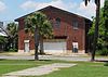 |
September 6, 2007 (#07000925) |
Middle St. and Thompson Ave., between Stations 14 and 16.5 32°45′35″N 79°51′11″W / 32.7597°N 79.8531°W | Sullivan's Island | |
| 34 | Fort Palmetto | August 11, 1982 (#82003842) |
Christ Church Parish 32°49′23″N 79°45′56″W / 32.8231°N 79.7656°W | Hamlin Sound | ||
| 35 | Fort Pemberton Site | November 21, 1978 (#78002498) |
Shoreline of the Stono River on the northwestern corner of James Island[11] 32°45′35″N 80°00′03″W / 32.7597°N 80.0008°W | James Island | ||
| 36 | Frogmore | May 5, 1987 (#86003203) |
South of Pine Landing Rd. near the intersection of South Carolina Highway 174 and Laurel Hill Rd. 32°35′16″N 80°21′21″W / 32.5878°N 80.3558°W | Edisto Island | ||
| 37 | General Asbestos and Rubber Company (GARCO) Main Mill |  |
February 28, 2017 (#100000687) |
0 O'Hear Ave. 32°53′01″N 79°58′30″W / 32.8835°N 79.9749°W | North Charleston | |
| 38 | Paul Grimball House Ruins | November 28, 1986 (#86003190) |
Address Restricted | Edisto Island | ||
| 39 | Grove Plantation |  |
August 25, 1978 (#78002495) |
Southwest of Adams Run off South Carolina Highway 174 32°39′54″N 80°23′37″W / 32.665°N 80.3936°W | Adams Run | |
| 40 | H. L. Hunley (submarine) |  |
December 29, 1978 (#78003412) |
Located on the old Naval base in North Charleston 32°44′00″N 79°46′00″W / 32.7333°N 79.7667°W | North Charleston | |
| 41 | Hampton Plantation |  |
April 15, 1970 (#70000582) |
1950 Rutledge Rd. 33°12′01″N 79°26′09″W / 33.2003°N 79.4358°W | McClellanville | |
| 42 | Hanckel Mound | October 15, 1970 (#70000586) |
Address Restricted | Rockville | ||
| 43 | Harrietta Plantation |  |
September 18, 1975 (#75001695) |
5 miles east of McClellanville off U.S. Route 17 33°10′10″N 79°23′37″W / 33.1694°N 79.3936°W | McClellanville | |
| 44 | Horse Island | November 10, 1970 (#70000587) |
Address Restricted | Rockville | ||
| 45 | Host of America Motel |  |
September 25, 2020 (#100005609) |
3245 Rivers Ave. 32°51′12″N 79°58′21″W / 32.8534°N 79.9726°W | North Charleston | |
| 46 | Hutchinson House |  |
May 5, 1987 (#86003218) |
7666 Point of Pines Rd. 32°34′12″N 80°15′26″W / 32.5700°N 80.2571°W | Edisto Island | |
| 47 | John's Island Presbyterian Church |  |
November 3, 1975 (#75001692) |
10 miles west of Charleston on South Carolina Highway 20 32°41′12″N 80°04′56″W / 32.6867°N 80.0822°W | Johns Island | |
| 48 | King Cemetery | June 13, 2000 (#00000586) |
1.1 miles northeast of the junction of U.S. Route 17 and S-19-38 32°46′10″N 80°22′51″W / 32.7694°N 80.3808°W | Adams Run | ||
| 49 | Lawton-Seabrook Cemetery | June 12, 2017 (#100001075) |
7938 Steamboat Landing Rd. 32°35′24″N 80°17′42″W / 32.5899°N 80.2949°W | Edisto Island | ||
| 50 | Lighthouse Point Shell Ring (38CH12) | October 14, 1990 (#90001505) |
Address Restricted | James Island | ||
| 51 | Long Point Plantation (38CH321) | March 20, 1986 (#86000468) |
Address Restricted | Mount Pleasant | ||
| 52 | Lucas Family Cemetery |  |
May 18, 1998 (#98000425) |
Ellen Dr. 32°47′45″N 79°52′18″W / 32.7958°N 79.8717°W | Mount Pleasant | |
| 53 | Magnolia Plantation and Gardens |  |
December 11, 1972 (#72001198) |
10 miles northwest of Charleston on South Carolina Highway 61 32°52′29″N 80°05′21″W / 32.8747°N 80.0892°W | West Ashley | |
| 54 | Marine Barracks, Charleston Navy Yard |  |
October 16, 2020 (#100005676) |
Truxtun Ave. between Marine and Goldberg Aves. 32°51′48″N 79°58′26″W / 32.8633°N 79.9739°W | North Charleston | |
| 55 | Marshlands Plantation House |  |
March 30, 1973 (#73001700) |
Northern side of Fort Sumter Dr. 32°45′01″N 79°54′03″W / 32.7503°N 79.9008°W | James Island | The house was moved from its original location at the old Naval Base in North Charleston for preservation. |
| 56 | McClellanville Historic District | March 23, 1982 (#82003845) |
Pinckney, Lofton, Charlotte, Church, Water, Oak, Venning, Legare, Morrison, and Scotia Sts. 33°05′06″N 79°27′43″W / 33.085°N 79.4619°W | McClellanville | ||
| 57 | W. Gresham Meggett High and Elementary School | February 20, 2018 (#100002098) |
1929 Grimball Rd. 32°42′25″N 79°58′34″W / 32.7069°N 79.9762°W | Charleston vicinity | ||
| 58 | Middleton's Plantation | May 6, 1971 (#71000755) |
3.5 miles north of Edisto Island off South Carolina Highway 174 32°33′25″N 80°19′48″W / 32.5569°N 80.33°W | Edisto Island | Not to be confused with Middleton Place in nearby Dorchester County | |
| 59 | Mosquito Beach Historic District | 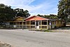 |
September 23, 2019 (#100004409) |
Mosquito Beach Rd. 32°40′22″N 79°58′57″W / 32.6728°N 79.9824°W | James Island vicinity | |
| 60 | Moultrieville Historic District |  |
September 6, 2007 (#07000928) |
Middle St. and Osceola Ave., between stations 11 and 12 32°45′39″N 79°51′33″W / 32.7608°N 79.8592°W | Sullivan's Island | Includes several late-19th and early-20th century beach houses and Stella Maris Church designed by John Henry Devereux |
| 61 | Mount Pleasant Historic District |  |
March 30, 1973 (#73001701) |
Bounded by Charleston Harbor, Shem Creek, Royall Ave., and McCants Dr. 32°47′10″N 79°52′33″W / 32.7861°N 79.8758°W | Mount Pleasant | |
| 62 | Moving Star Hall | June 17, 1982 (#82003843) |
River Rd. 32°40′55″N 80°01′33″W / 32.6819°N 80.0258°W | Johns Island | ||
| 63 | Oak Island |  |
November 28, 1986 (#86003202) |
1 mile off Oak Island Rd. on Westbank Creek 32°35′39″N 80°15′05″W / 32.5942°N 80.2514°W | Edisto Island | |
| 64 | Oakland Plantation House |  |
July 13, 1977 (#77001218) |
7 miles north of Charleston Harbor on U.S. Route 17 32°51′59″N 79°45′18″W / 32.8664°N 79.755°W | Mount Pleasant | |
| 65 | Old Courthouse |  |
May 6, 1971 (#71000760) |
331 King St. 32°47′06″N 79°51′50″W / 32.7850°N 79.8639°W | Mount Pleasant | |
| 66 | Old Georgetown Road | June 27, 2014 (#14000382) |
Old Georgetown Road between south bank of the South Santee River and SC 45 33°09′15″N 79°28′46″W / 33.1541°N 79.4795°W | McClellanville | ||
| 67 | Old House Plantation |  |
May 14, 1971 (#71000756) |
Northeast of Edisto Island via South Carolina Highway 174; also 0.5 miles east of the junction of South Carolina Highway 174 and Oak Island Rd., then right on a dirt road 32°34′49″N 80°15′37″W / 32.5803°N 80.2603°W | Edisto Island | Second address represents a boundary increase of May 5, 1987 |
| 68 | Dr. John B. Patrick House | 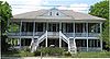 |
February 9, 1995 (#94001628) |
1820 Middle St. 32°45′35″N 79°50′36″W / 32.7597°N 79.8433°W | Sullivan's Island | |
| 69 | Peter's Point Plantation | 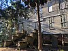 |
June 19, 1973 (#73001699) |
9084 Peter's Point Road, Edisto, South Carolina 32°32′19″N 80°20′22″W / 32.5386°N 80.3394°W | Edisto Island | |
| 70 | Phillips Community Historic District | September 7, 2023 (#100008589) |
SC 41, approx. between Virginia Rouse and Joe Rouse Rds., roughly bounded by Horlbeck Cr., Dunes West, and Park West 32°52′59″N 79°48′39″W / 32.8830°N 79.8108°W | Mount Pleasant vicinity | ||
| 71 | Presbyterian Manse | May 14, 1971 (#71000757) |
Northwest of Edisto Island off South Carolina Highway 174 32°34′04″N 80°18′34″W / 32.5678°N 80.3094°W | Edisto Island | ||
| 72 | Paul Pritchard Shipyard | September 17, 1974 (#74001839) |
Address Restricted | Mount Pleasant | ||
| 73 | The Progressive Club | 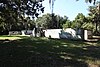 |
October 24, 2007 (#07001109) |
3377 River Rd. 32°40′37″N 80°02′26″W / 32.6769°N 80.0406°W | Johns Island | |
| 74 | Prospect Hill |  |
November 28, 1986 (#86003196) |
Off Laurel Hill Rd. 32°34′54″N 80°23′04″W / 32.5817°N 80.3844°W | Edisto Island | |
| 75 | Remley Point Cemetery |  |
May 30, 2002 (#02000570) |
0.2 miles northeast of the junction of 3rd and 4th Aves. 32°48′51″N 79°53′53″W / 32.8142°N 79.8981°W | Mount Pleasant | |
| 76 | Rockville Historic District | 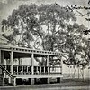 |
June 13, 1972 (#72001202) |
Town of Rockville on the northern bank of Bohicket Creek 32°36′18″N 80°11′35″W / 32.605°N 80.1931°W | Rockville | |
| 77 | St. James Episcopal Church, Santee |  |
April 15, 1970 (#70000581) |
17 miles south of Georgetown on the Santee River 33°10′19″N 79°27′56″W / 33.1719°N 79.4656°W | Georgetown | |
| 78 | John Seabrook Plantation Bridge | October 9, 1974 (#74001841) |
Northwest of Rockville off South Carolina Highway 700 32°37′38″N 80°12′37″W / 32.6272°N 80.2103°W | Rockville | ||
| 79 | William Seabrook House | 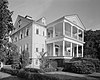 |
May 6, 1971 (#71000758) |
North of Edisto Island off South Carolina Highway 174 32°36′06″N 80°16′53″W / 32.6017°N 80.2814°W | Edisto Island | |
| 80 | Seashore Farmers' Lodge No. 767 |  |
October 3, 2007 (#07001043) |
Northeastern corner of the junction of Sol Legare and Old Sol Legare Rds. 32°40′54″N 79°58′02″W / 32.6817°N 79.9672°W | James Island | |
| 81 | Seaside Plantation House |  |
January 21, 1982 (#82003840) |
Off South Carolina Highway 174 32°31′14″N 80°17′23″W / 32.5206°N 80.2897°W | Edisto Island | |
| 82 | Seaside School | June 17, 1994 (#94000602) |
1097 South Carolina Highway 174 32°32′51″N 80°16′54″W / 32.5475°N 80.2817°W | Edisto Island | ||
| 83 | Secessionville Historic District |  |
October 1, 1979 (#79002378) |
North of Folly Beach 32°42′18″N 79°56′35″W / 32.705°N 79.9431°W | Folly Beach | Extends into Charleston |
| 84 | Sewee Mound | 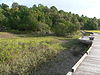 |
October 15, 1970 (#70000571) |
Salt Pond Road (FS Road 243)[12] 32°59′48″N 79°36′37″W / 32.9967°N 79.6103°W | Awendaw | |
| 85 | Slave Street, Smokehouse, and Allee, Boone Hall Plantation | 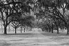 |
July 14, 1983 (#93001512) |
North of Mt. Pleasant off U.S. Route 17; also Long Point Rd. west of its junction with U.S. Routes 17/701 32°51′29″N 79°49′23″W / 32.8581°N 79.8231°W | Mount Pleasant | Second location represents a boundary increase of January 21, 1994, the Boone Hall Plantation House and Historic Landscape |
| 86 | Snee Farm-Charles Pinckney National Historic Site |  |
April 13, 1973 (#73001702) |
6 miles west of Mt. Pleasant at 1254 Long Point Rd. 32°50′46″N 79°49′29″W / 32.8461°N 79.8247°W | Mount Pleasant | Boundary increase approved October 10, 2021. |
| 87 | Stono River Slave Rebellion Site |  |
May 30, 1974 (#74001840) |
Off U.S. Route 17 on the western bank of the Wallace River 32°47′14″N 80°08′44″W / 32.7872°N 80.1456°W | Rantowles | |
| 88 | Sullivan's Island Historic District |  |
September 6, 2007 (#07000929) |
Middle St., I'on Ave., and Central Ave. between Stations 17 and 18½ 32°45′33″N 79°50′45″W / 32.7592°N 79.8458°W | Sullivan's Island | |
| 89 | Summit Plantation House |  |
July 28, 1983 (#83002188) |
Off County Road 390 32°41′37″N 80°17′10″W / 32.6936°N 80.2861°W | Adams Run | |
| 90 | Sunnyside |  |
November 28, 1986 (#86003216) |
Off the northern side of Peter's Point Rd.; also north of the junction of Peters Point and Creekwood Rd. 32°33′57″N 80°17′50″W / 32.5658°N 80.2972°W | Edisto Island | A plantation on Edisto Island. Second location represents a boundary increase, the Sunnyside Plantation Foreman's House |
| 91 | Towles Farmstead | January 21, 1994 (#93001513) |
4595 and 4611 Towles Rd. 32°43′14″N 80°11′06″W / 32.7206°N 80.185°W | Meggett | ||
| 92 | Hephzibah Jenkins Townsend's Tabby Oven Ruins | May 5, 1987 (#86003200) |
Address Restricted | Edisto Island | ||
| 93 | Trinity Church |  |
May 14, 1971 (#71000759) |
1589 South Carolina Highway 174[13] 32°34′10″N 80°17′01″W / 32.5694°N 80.2836°W | Edisto Island | |
| 94 | U.S. Coast Guard Historic District |  |
June 19, 1973 (#73001703) |
Ion Ave. between Station 18 and Station 18½ 32°45′27″N 79°50′33″W / 32.7575°N 79.8425°W | Sullivan's Island | |
| 95 | Unnamed Battery No. 1 | August 11, 1982 (#82003838) |
Clark's Point 32°43′15″N 79°56′07″W / 32.7208°N 79.9353°W | James Island | ||
| 96 | USS CLAMAGORE (SS-343) |  |
June 29, 1989 (#89001229) |
Patriot's Point 32°47′23″N 79°54′28″W / 32.7897°N 79.9078°W | Mount Pleasant | |
| 97 | USS LAFFEY | 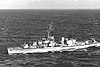 |
April 12, 1983 (#83002189) |
West of Mt. Pleasant on the eastern side of Charleston Harbor 32°47′23″N 79°54′28″W / 32.7897°N 79.9078°W | Mount Pleasant | |
| 98 | USS YORKTOWN (CV-10) |  |
November 10, 1982 (#82001519) |
West of Mt. Pleasant on the eastern side of Charleston Harbor 32°47′26″N 79°54′31″W / 32.7906°N 79.9086°W | Mount Pleasant | |
| 99 | Arnoldus Vander Horst House | October 25, 1973 (#73001697) |
25 miles southwest of Charleston on Kiawah Island 32°37′00″N 80°04′24″W / 32.6167°N 80.0733°W | Kiawah Island | ||
| 100 | The Wedge |  |
November 25, 1980 (#80003660) |
Northeast of McClellanville 33°10′17″N 79°23′57″W / 33.1714°N 79.3992°W | McClellanville | |
| 101 | Wescott Road |  |
November 28, 1986 (#86003195) |
West of South Carolina Highway 174 32°33′44″N 80°16′53″W / 32.5622°N 80.2814°W | Edisto Island | |
| 102 | Wilkinson-Boineau House |  |
January 21, 1999 (#98001644) |
5185 South Carolina Highway 174 32°43′10″N 80°20′56″W / 32.7195°N 80.3490°W | Adams Run | |
| 103 | Willtown Bluff |  |
January 8, 1974 (#74001830) |
Southwest of Adams Run at the end of County Road 55 on the banks of the S. Edisto River 32°40′54″N 80°24′54″W / 32.6817°N 80.415°W | Adams Run | |
| 104 | Windsor Plantation | July 23, 1974 (#74001837) |
East of South Carolina Highway 174 near Little Edisto 32°35′58″N 80°20′41″W / 32.5994°N 80.3447°W | Edisto Island |
Former listings edit
| [3] | Name on the Register | Image | Date listed | Date removed | Location | City or town | Description |
|---|---|---|---|---|---|---|---|
| 1 | Laurel Hill | September 23, 1985 (#85002359) | March 15, 2000 | McClellanville | Destroyed by Hurricane Hugo on September 21, 1989.[14] | ||
| 2 | Point of Pines Plantation Slave Cabin | November 28, 1986 (#86003213) | October 23, 2013 | Point of Pines Rd. 32°34′39″N 80°14′25″W / 32.5775°N 80.2403°W | Edisto Island | Moved to the National Museum of African American History and Culture in Washington, D.C. in May 2013.[15] | |
| 3 | NS Savannah |  |
November 14, 1982 (#82001518) | December 8, 2005 | Partiot's Points | Mount Pleasant | Moved to Newport News, Virginia |
| 4 | Williams Graded School | August 21, 1980 (#80003659) | January 27, 1983 | Pinckney St. | Lincolnville | Destroyed by arsonist on June 20, 1982.[16] |
See also edit
References edit
- ^ The latitude and longitude information provided in this table was derived originally from the National Register Information System, which has been found to be fairly accurate for about 99% of listings. Some locations in this table may have been corrected to current GPS standards.
- ^ National Park Service, United States Department of the Interior, "National Register of Historic Places: Weekly List Actions", retrieved April 12, 2024.
- ^ a b Numbers represent an alphabetical ordering by significant words. Various colorings, defined here, differentiate National Historic Landmarks and historic districts from other NRHP buildings, structures, sites or objects.
- ^ "National Register Information System". National Register of Historic Places. National Park Service. March 13, 2009.
- ^ The eight-digit number below each date is the number assigned to each location in the National Register Information System database, which can be viewed by clicking the number.
- ^ Federal and state laws and practices restrict general public access to information regarding the specific location of this resource. In some cases, this is to protect archeological sites from vandalism, while in other cases it is restricted at the request of the owner. See: Knoerl, John; Miller, Diane; Shrimpton, Rebecca H. (1990), Guidelines for Restricting Information about Historic and Prehistoric Resources, National Register Bulletin, National Park Service, U.S. Department of the Interior, OCLC 20706997.
- ^ "About The Gallery". With These Hands Gallery. Retrieved 2013-01-12.
- ^ Richard Sidebottom (June 2010). "Charleston Naval Hospital Historic District" (PDF). National Register of Historic Places - Nomination and Inventory. Retrieved 2014-08-01.
- ^ "Contact Us". Christ Church--Mount Pleasant website. Retrieved 2011-09-10.
- ^ "Contact Us". Archived 2013-11-27 at the Wayback Machine New First Missionary Baptist Church. Archived 2013-11-27 at the Wayback Machine Retrieved 2013-01-13.
- ^ Location derived from its GNIS feature record; the NRIS lists the site as "Address Restricted"
- ^ "Sewee Shell Mound Interpretive Trail". U.S. Forest Service. Retrieved 2011-09-07.
- ^ Trinity Episcopal Church website. Retrieved 2013-01-13.
- ^ SCDAH
- ^ "Slave Cabin Set to Become Centerpiece of New Smithsonian Museum".
- ^ "Fire which razes schoolhouse reportedly deliberately set". Columbia Record. June 21, 1982. p. 2C9. Retrieved August 22, 2022 – via Newspapers.com.