
KNOWPIA
WELCOME TO KNOWPIA

National Register of Historic Places listings in Clay County, Florida 
Summary
This is a list of the National Register of Historic Places listings in Clay County, Florida.

This is intended to be a complete list of the properties and districts on the National Register of Historic Places in Clay County, Florida, United States. The locations of National Register properties and districts for which the latitude and longitude coordinates are included below, may be seen in a map.[1]
There are 24 properties and districts listed on the National Register in the county.
This National Park Service list is complete through NPS recent listings posted April 12, 2024.[2]
| Alachua - Baker - Bay - Bradford - Brevard - Broward - Calhoun - Charlotte - Citrus - Clay - Collier - Columbia - DeSoto - Dixie - Duval - Escambia - Flagler - Franklin - Gadsden - Gilchrist - Glades - Gulf - Hamilton - Hardee - Hendry - Hernando - Highlands - Hillsborough (Tampa) - Holmes - Indian River - Jackson - Jefferson - Lafayette - Lake - Lee - Leon - Levy - Liberty - Madison - Manatee - Marion - Martin - Miami-Dade (Miami) - Monroe - Nassau - Okaloosa - Okeechobee - Orange - Osceola - Palm Beach - Pasco - Pinellas - Polk - Putnam - St. Johns - St. Lucie - Santa Rosa - Sarasota - Seminole - Sumter - Suwannee - Taylor - Union - Volusia - Wakulla - Walton - Washington |
Current listings edit
| [3] | Name on the Register[4] | Image | Date listed[5] | Location | City or town | Description |
|---|---|---|---|---|---|---|
| 1 | Bubba Midden (8CL84) | March 2, 1990 (#90000159) |
Address Restricted | Fleming Island | ||
| 2 | Frosard W. Budington House |  |
March 9, 1990 (#90000317) |
3916 Main Street 30°04′08″N 81°51′45″W / 30.0689°N 81.8625°W | Middleburg | Part of the Middleburg MPS |
| 3 | George A. Chalker House |  |
March 9, 1990 (#90000315) |
2160 Wharf Street 30°04′03″N 81°51′37″W / 30.0675°N 81.8603°W | Middleburg | Part of the Middleburg MPS |
| 4 | Clark-Chalker House | 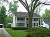 |
October 5, 1988 (#88001701) |
3891 Main Street 30°04′07″N 81°51′37″W / 30.0686°N 81.8603°W | Middleburg | |
| 5 | William Clarke Estate |  |
July 15, 1998 (#98000862) |
1039-1057 Kingsley Avenue 30°09′58″N 81°43′00″W / 30.1661°N 81.7167°W | Orange Park | Part of the Orange Park, Florida MPS |
| 6 | Clay County Courthouse |  |
June 20, 1975 (#75000546) |
Brabantio Avenue 29°59′28″N 81°41′06″W / 29.9911°N 81.685°W | Green Cove Springs | |
| 7 | George Randolph Frisbee Jr. House |  |
March 9, 1990 (#90000316) |
2125 Palmetto Street 30°04′12″N 81°51′40″W / 30.07°N 81.8611°W | Middleburg | Part of the Middleburg MPS |
| 8 | Gold Head Branch State Park |  |
July 21, 2020 (#100005381) |
6239 FL 21 29°49′55″N 81°57′11″W / 29.8319°N 81.9531°W | Keystone Heights vicinity | |
| 8 | Green Cove Springs Historic District |  |
March 28, 1991 (#91000281) |
Roughly bounded by Bay Street, the CSX railroad tracks, Center Street, Orange Avenue, St. Elmo Street, and the St. Johns River 29°59′38″N 81°40′50″W / 29.9939°N 81.6806°W | Green Cove Springs | |
| 9 | Joseph Green House |  |
July 15, 1998 (#98000860) |
531 McIntosh Avenue 30°10′02″N 81°42′22″W / 30.1672°N 81.7061°W | Orange Park | Part of the Orange Park, Florida MPS. Photo is of building on site. The house was demolished in 1999.[6] |
| 10 | Haskell-Long House |  |
March 9, 1990 (#90000314) |
3858 Main Street 30°04′14″N 81°51′29″W / 30.0706°N 81.8581°W | Middleburg | Part of the Middleburg MPS |
| 11 | William Helffrich House |  |
July 15, 1998 (#98000857) |
1200 Plainfield Avenue 30°10′32″N 81°42′21″W / 30.1756°N 81.7058°W | Orange Park | Part of the Orange Park, Florida MPS |
| 12 | Holly Cottage |  |
July 8, 2010 (#10000442) |
6935 Old Church Road 30°03′54″N 81°41′48″W / 30.065°N 81.6967°W | Green Cove Springs vicinity | |
| 13 | Memorial Home Community Historic District |  |
February 3, 1999 (#99000047) |
Roughly bounded by State Road 16, Caroline Boulevard, Wilbanks Avenue, and Studio Road 29°58′56″N 81°48′29″W / 29.9822°N 81.8081°W | Penney Farms | |
| 14 | Black Creek Methodist Church |  |
March 9, 1990 (#90000318) |
3925 Main Street 30°04′04″N 81°51′46″W / 30.0678°N 81.8628°W | Middleburg | Part of the Middleburg MPS |
| 15 | Middleburg Historic District |  |
March 9, 1990 (#90000313) |
3881-3895 Main Street and 2145 Wharf Street 30°04′09″N 81°51′36″W / 30.0692°N 81.86°W | Middleburg | Part of the Middleburg MPS |
| 16 | Orange Park Elementary School | 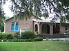 |
July 15, 1998 (#98000858) |
1401 Plainfield Avenue 30°10′20″N 81°42′19″W / 30.1722°N 81.7053°W | Orange Park | Part of the Orange Park, Florida MPS |
| 17 | Orange Park Negro Elementary School |  |
July 15, 1998 (#98000856) |
440 McIntosh Avenue 30°10′01″N 81°42′15″W / 30.1669°N 81.7042°W | Orange Park | Part of the Orange Park, Florida MPS |
| 18 | Princess Mound (8CL85) | March 2, 1990 (#90000311) |
Address Restricted | Green Cove Springs | ||
| 19 | River Road Historic District |  |
July 15, 1998 (#98000861) |
Junction of River Road and Stiles Avenue 30°10′20″N 81°41′53″W / 30.1722°N 81.6981°W | Orange Park | Part of the Orange Park, Florida MPS |
| 20 | St. Margaret's Episcopal Church and Cemetery |  |
June 4, 1973 (#73000570) |
6874 Old Church Road 30°04′02″N 81°41′48″W / 30.0672°N 81.6967°W | Hibernia | |
| 21 | St. Mary's Church |  |
February 17, 1978 (#78000933) |
St. Johns Avenue 29°59′50″N 81°40′41″W / 29.9972°N 81.6781°W | Green Cove Springs | |
| 22 | William Westcott House |  |
July 15, 1998 (#98000859) |
443 Stiles Avenue 30°09′58″N 81°43′00″W / 30.1661°N 81.7167°W | Orange Park | Part of the Orange Park, Florida MPS |
| 23 | Winterbourne |  |
February 23, 1996 (#96000161) |
2104 Winterbourne West 30°09′51″N 81°41′48″W / 30.1642°N 81.6967°W | Orange Park |
See also edit
Wikimedia Commons has media related to National Register of Historic Places in Clay County, Florida.
References edit
- ^ The latitude and longitude information provided in this table was derived originally from the National Register Information System, which has been found to be fairly accurate for about 99% of listings. Some locations in this table may have been corrected to current GPS standards.
- ^ National Park Service, United States Department of the Interior, "National Register of Historic Places: Weekly List Actions", retrieved April 12, 2024.
- ^ Numbers represent an alphabetical ordering by significant words. Various colorings, defined here, differentiate National Historic Landmarks and historic districts from other NRHP buildings, structures, sites or objects.
- ^ "National Register Information System". National Register of Historic Places. National Park Service. March 13, 2009.
- ^ The eight-digit number below each date is the number assigned to each location in the National Register Information System database, which can be viewed by clicking the number.
- ^ Historic house faces demolition, Caren Burmeister, Jacksonville Times-Union, April 19, 1999, accessed January 16, 2012