
KNOWPIA
WELCOME TO KNOWPIA

National Register of Historic Places listings in Closter, New Jersey 
Summary
List of the National Register of Historic Places listings in the borough of Closter in Bergen County, New Jersey

| Atlantic – Bergen (Closter, Franklin Lakes, Ridgewood, Saddle River, Wyckoff) – Burlington – Camden – Cape May – Cumberland – Essex – Gloucester – Hudson – Hunterdon – Mercer – Middlesex – Monmouth – Morris – Ocean – Passaic – Salem – Somerset – Sussex – Union – Warren |
The table below includes 10 sites listed on the National Register of Historic Places in the borough of Closter in Bergen County, New Jersey. Latitude and longitude coordinates of the sites listed on this page may be displayed in an online map.[1]
This National Park Service list is complete through NPS recent listings posted April 12, 2024.[2]
Current listings edit
| [3] | Name on the Register[4] | Image | Date listed[5] | Location | Description |
|---|---|---|---|---|---|
| 1 | William De Clark House | 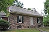 |
January 9, 1983 (#83001488) |
145 Piermont Road 40°58′41″N 73°56′40″W / 40.978056°N 73.944444°W |
Part of the Early Stone Houses of Bergen County Multiple Property Submission (MPS) |
| 2 | Abram Demaree House |  |
November 1, 1979 (#79001471) |
45 Old Hook Road, Schraalenburgh and Old Hooks Roads 40°58′35″N 73°58′53″W / 40.976389°N 73.981389°W |
Part of the Early Stone Houses of Bergen County MPS |
| 3 | Haring–Auryanson House | 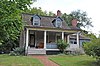 |
August 15, 1983 (#83001516) |
377 Piermont Road 40°58′17″N 73°56′53″W / 40.971389°N 73.948056°W |
Part of the Early Stone Houses of Bergen County MPS |
| 4 | Harold Hess Lustron House |  |
July 25, 2000 (#00000796) |
421 Durie Avenue 40°58′15″N 73°58′02″W / 40.970833°N 73.967222°W |
Part of the Lustrons in New Jersey MPS |
| 5 | John Nagle House | 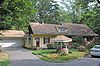 |
January 9, 1983 (#83001534) |
75 Harvard Street 40°58′46″N 73°56′27″W / 40.979444°N 73.940833°W |
Part of the Early Stone Houses of Bergen County MPS, also known as the John Naugle House |
| 6 | Henry Naugle House |  |
January 9, 1983 (#83001535) |
119 Hickory Lane 40°58′24″N 73°56′26″W / 40.973333°N 73.940556°W |
Part of the Early Stone Houses of Bergen County MPS |
| 7 | Isaac Naugle House |  |
January 9, 1983 (#83001537) |
80 Hickory Lane 40°58′21″N 73°56′34″W / 40.9725°N 73.942778°W |
Part of the Early Stone Houses of Bergen County MPS |
| 8 | Tallman–Vanderbeck House | 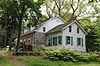 |
January 9, 1983 (#83001551) |
639 Piermont Road 40°57′59″N 73°57′15″W / 40.966389°N 73.954167°W |
Part of the Early Stone Houses of Bergen County MPS |
| 9 | David and Cornelius Van Horn House | 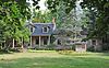 |
January 9, 1983 (#83001572) |
11 Cedar Lane 40°58′37″N 73°58′50″W / 40.976944°N 73.980556°W |
Part of the Early Stone Houses of Bergen County MPS |
| 10 | Vervalen House |  |
January 9, 1983 (#83001580) |
151 West Street 40°58′43″N 73°57′50″W / 40.978611°N 73.963889°W |
Part of the Early Stone Houses of Bergen County MPS |
References edit
- ^ The latitude and longitude information provided in this table was derived originally from the National Register Information System, which has been found to be fairly accurate for about 99% of listings. Some locations in this table may have been corrected to current GPS standards.
- ^ National Park Service, United States Department of the Interior, "National Register of Historic Places: Weekly List Actions", retrieved April 12, 2024.
- ^ Numbers represent an alphabetical ordering by significant words. Various colorings, defined here, differentiate National Historic Landmarks and historic districts from other NRHP buildings, structures, sites or objects.
- ^ "National Register Information System". National Register of Historic Places. National Park Service. July 9, 2010.
- ^ The eight-digit number below each date is the number assigned to each location in the National Register Information System database, which can be viewed by clicking the number.