
KNOWPIA
WELCOME TO KNOWPIA

National Register of Historic Places listings in Coahoma County, Mississippi 
Summary
This is a list of the National Register of Historic Places listings in Coahoma County, Mississippi.

This is intended to be a complete list of the properties and districts on the National Register of Historic Places in Coahoma County, Mississippi, United States. Latitude and longitude coordinates are provided for many National Register properties and districts; these locations may be seen together in a map.[1]
There are 22 properties and districts listed on the National Register in the county.
This National Park Service list is complete through NPS recent listings posted April 12, 2024.[2]
Current listings edit
| [3] | Name on the Register[4] | Image | Date listed[5] | Location | City or town | Description |
|---|---|---|---|---|---|---|
| 1 | Barner Site (22CO542) | March 8, 1984 (#84002129) |
Address restricted[6] | Clarksdale | ||
| 2 | Bobo Senior High School Building | March 19, 2008 (#08000196) |
131 School St. 34°11′57″N 90°34′43″W / 34.199167°N 90.578611°W | Clarksdale | ||
| 3 | Carson Mounds | April 19, 1979 (#79003382) |
Northeastern quarter of the northwestern quarter of Section 24, Township 28 North, Range 5 West[7]: 51 34°17′37″N 90°40′17″W / 34.293611°N 90.671389°W | Clarksdale | ||
| 4 | John Clark House | July 5, 2003 (#03000589) |
211 Clark St. 34°12′23″N 90°34′28″W / 34.206389°N 90.574444°W | Clarksdale | ||
| 5 | Clarksdale Historic District | September 14, 2009 (#09000763) |
Roughly bounded by the Sunflower River, 10th St., DeSoto Ave., and Clark St. 34°11′55″N 90°34′10″W / 34.198564°N 90.569381°W | Clarksdale | ||
| 6 | Rufus Davis Site | June 15, 1978 (#78001597) |
Northeastern quarter of the northeastern quarter of Section 5, Township 27 North, Range 4 West[7]: 53 34°14′54″N 90°37′32″W / 34.248333°N 90.625556°W | Clarksdale | ||
| 7 | Dickerson Site (22CO502) | September 11, 1986 (#86002323) |
Address restricted[6] | Friars Point | ||
| 8 | Friars Point Historic District |  |
January 28, 1999 (#98001608) |
Along 2nd St. 34°22′20″N 90°38′14″W / 34.372222°N 90.637222°W | Friars Point | |
| 9 | Humber Site | May 12, 1975 (#75001043) |
Address restricted[6] | Farrel | ||
| 10 | Myrtle Hall Branch Library for Negroes | January 25, 2018 (#100002027) |
1109 N. State St. 34°11′44″N 90°33′41″W / 34.195436°N 90.561362°W | Clarksdale | ||
| 11 | New Alcazar Hotel |  |
June 24, 1994 (#94000646) |
127 3rd St. 34°12′05″N 90°34′25″W / 34.201389°N 90.573611°W | Clarksdale | |
| 12 | Oliver Site | December 30, 1974 (#74001061) |
Northwestern quarter of the northwestern quarter of Section 10, Township 25, Range 4 West[7]: 53 34°03′28″N 90°36′14″W / 34.057778°N 90.603889°W | Clarksdale | ||
| 13 | Parchman Place Site | May 17, 1973 (#73001005) |
Southwestern quarter of the northwestern quarter of Section 30, Township 29 North, Range 3 West[7]: 51 34°21′34″N 90°33′00″W / 34.359444°N 90.550000°W | Coahoma | ||
| 14 | Prairie Plantation House | November 10, 1994 (#94001305) |
1545 Old River Rd. 34°18′22″N 90°39′12″W / 34.306111°N 90.653333°W | Clarksdale | ||
| 15 | Salomon (Salmon) Site | March 8, 1984 (#84002134) |
Northeastern quarter of the northeastern quarter of Section 22, Township 29 North, Range 3 West[7]: 51 34°22′39″N 90°29′24″W / 34.377500°N 90.490000°W | Coahoma | ||
| 16 | Spendthrift Site (22CO520) | September 11, 1986 (#86002330) |
Northwestern quarter of the northwestern quarter of Section 13, Township 26 North, Range 3 West[7]: 53 34°07′44″N 90°27′51″W / 34.128889°N 90.464167°W | Mattson | ||
| 17 | Sunflower Landing | October 2, 1991 (#91001422) |
Address restricted[6] | Rena Lara | ||
| 18 | Wilsford | December 30, 1974 (#74001062) |
Address restricted[6] | Lula | ||
| 19 | Woolworth Building | March 19, 2009 (#09000110) |
207 Yazoo Ave. 34°12′10″N 90°34′25″W / 34.202794°N 90.573708°W | Clarksdale | ||
| 20 | WROX Building | 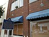 |
August 9, 2002 (#02000854) |
257 Delta Ave. 34°12′05″N 90°34′29″W / 34.201389°N 90.574722°W | Clarksdale | |
| 21 | Yazoo and Mississippi Valley Passenger Depot | 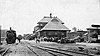 |
October 31, 1995 (#95001194) |
1 Blues Alley 34°12′03″N 90°34′15″W / 34.200833°N 90.570833°W | Clarksdale | Later the Illinois Central |
| 22 | Yazoo Pass Levee | June 19, 1973 (#73001006) |
Near Moon Lake on Mississippi Highway 1 34°26′57″N 90°33′02″W / 34.449167°N 90.550556°W | Moon Lake |
See also edit
Wikimedia Commons has media related to National Register of Historic Places in Coahoma County, Mississippi.
References edit
- ^ The latitude and longitude information provided in this table was derived originally from the National Register Information System, which has been found to be fairly accurate for about 99% of listings. Some locations in this table may have been corrected to current GPS standards.
- ^ National Park Service, United States Department of the Interior, "National Register of Historic Places: Weekly List Actions", retrieved April 12, 2024.
- ^ Numbers represent an alphabetical ordering by significant words. Various colorings, defined here, differentiate National Historic Landmarks and historic districts from other NRHP buildings, structures, sites or objects.
- ^ "National Register Information System". National Register of Historic Places. National Park Service. March 13, 2009.
- ^ The eight-digit number below each date is the number assigned to each location in the National Register Information System database, which can be viewed by clicking the number.
- ^ a b c d e Federal and state laws and practices restrict general public access to information regarding the specific location of this resource. In some cases, this is to protect archeological sites from vandalism, while in other cases it is restricted at the request of the owner. See: Knoerl, John; Miller, Diane; Shrimpton, Rebecca H. (1990), Guidelines for Restricting Information about Historic and Prehistoric Resources, National Register Bulletin, National Park Service, U.S. Department of the Interior, OCLC 20706997.
- ^ a b c d e f Phillips, Philip, et al. Archaeological Survey in the Lower Mississippi Alluvial Valley 1940-1947. Reprint ed. Tuscaloosa: U of Alabama P, 2003.