
KNOWPIA
WELCOME TO KNOWPIA

National Register of Historic Places listings in Colonial Heights, Virginia 
Summary
This is a list of the National Register of Historic Places listings in Colonial Heights, Virginia.
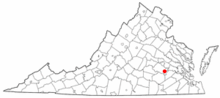
This is intended to be a complete list of the properties and districts on the National Register of Historic Places in the independent city of Colonial Heights, Virginia, United States. The locations of National Register properties and districts for which the latitude and longitude coordinates are included below, may be seen in a Google map.[1]
There are 8 properties and districts listed on the National Register in the city.
This National Park Service list is complete through NPS recent listings posted April 12, 2024.[2]
Current listings edit
| [3] | Name on the Register[4] | Image | Date listed[5] | Location | Description |
|---|---|---|---|---|---|
| 1 | Chesterfield Highlands Historic District |  |
July 23, 2013 (#13000540) |
Roughly bounded by the Boulevard and E. Westover, Lafayette, Pickwick, Danville, and Lee Aves. 37°14′56″N 77°24′26″W / 37.248889°N 77.407222°W |
|
| 2 | Conjurer's Field Archeological Site (44CF20) |  |
October 25, 1990 (#90001139) |
Along the Appomattox River near the Kennon House[6] 37°17′09″N 77°21′55″W / 37.285833°N 77.365278°W |
|
| 3 | Conjurer's Neck Archeological District |  |
October 23, 2003 (#03001090) |
131 Waterfront Dr.[6] 37°17′07″N 77°21′57″W / 37.285278°N 77.365833°W |
Address is that of the Kennon House, which is included in the district[6] |
| 4 | Ellerslie |  |
December 4, 1973 (#73002206) |
Ellerslie Rd. 37°16′17″N 77°24′16″W / 37.271389°N 77.404444°W |
|
| 5 | Fort Clifton Archeological Site |  |
February 3, 1981 (#81000639) |
Fort Clifton Park 37°16′52″N 77°21′56″W / 37.281111°N 77.365556°W |
Remains of a Civil War fortification |
| 6 | Oak Hill | 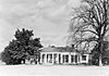 |
July 30, 1974 (#74002233) |
151 Carroll Ave. 37°14′13″N 77°24′33″W / 37.237083°N 77.409167°W |
|
| 7 | Violet Bank |  |
July 30, 1974 (#74002234) |
Royal Oak Ave. 37°14′31″N 77°24′19″W / 37.241944°N 77.405139°W |
|
| 8 | Violet Bank Historic District |  |
September 29, 2015 (#15000679) |
Lee, Lafayette, Hamilton, Cameron, Virginia, and Royal Oak Aves., and Arlington Place 37°14′34″N 77°24′21″W / 37.242778°N 77.405833°W |
See also edit
Wikimedia Commons has media related to National Register of Historic Places in Colonial Heights, Virginia.
References edit
- ^ The latitude and longitude information provided in this table was derived originally from the National Register Information System, which has been found to be fairly accurate for about 99% of listings. Some locations in this table may have been corrected to current GPS standards.
- ^ National Park Service, United States Department of the Interior, "National Register of Historic Places: Weekly List Actions", retrieved April 12, 2024.
- ^ Numbers represent an alphabetical ordering by significant words. Various colorings, defined here, differentiate National Historic Landmarks and historic districts from other NRHP buildings, structures, sites or objects.
- ^ "National Register Information System". National Register of Historic Places. National Park Service. April 24, 2008.
- ^ The eight-digit number below each date is the number assigned to each location in the National Register Information System database, which can be viewed by clicking the number.
- ^ a b c Old Brick House, City of Colonial Heights, n.d. Accessed 2016-12-20.