
KNOWPIA
WELCOME TO KNOWPIA

National Register of Historic Places listings in Cowlitz County, Washington 
Summary
This list presents the full set of buildings, structures, objects, sites, or districts designated on the National Register of Historic Places in Cowlitz County, Washington, and offers brief descriptive information about each of them. The National Register recognizes places of national, state, or local historic significance across the United States.[1] Out of over 90,000 National Register sites nationwide,[2] Washington is home to approximately 1,500,[3] and 32 of those are found partially or wholly in Cowlitz County.

This National Park Service list is complete through NPS recent listings posted April 12, 2024.[4]
Current listings edit
| [5] | Name on the Register[6] | Image | Date listed[7] | Location | City or town | Description |
|---|---|---|---|---|---|---|
| 1 | Berwind–Purcell House |  |
July 6, 2010 (#10000416) |
808 Lone Oak Rd. 46°10′56″N 122°57′58″W / 46.182222°N 122.966111°W | Longview | |
| 2 | Big Four Furniture Building | 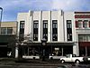 |
December 5, 1985 (#85003013) |
1329 Commerce Ave. 46°08′18″N 122°55′54″W / 46.138333°N 122.931667°W | Longview | Built in 1924 for Lumberman's Bank. Civic, Cultural, and Commercial Resources of Longview Thematic Resource MPS[8] |
| 3 | Adam Catlin House | 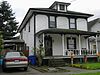 |
December 9, 1994 (#94001434) |
202 NW. Second Ave. 46°08′49″N 122°54′55″W / 46.146944°N 122.915278°W | Kelso | |
| 4 | Columbia Theater |  |
December 5, 1985 (#85003014) |
1225 Vandercook Way 46°08′27″N 122°55′53″W / 46.140833°N 122.931389°W | Longview | Civic, Cultural, and Commercial Resources of Longview Thematic Resource MPS |
| 5 | First Christian Church | 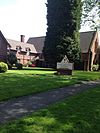 |
December 5, 1985 (#85003015) |
2000 E. Kessler Blvd. 46°07′53″N 122°56′45″W / 46.131389°N 122.945833°W | Longview | Civic, Cultural, and Commercial Resources of Longview Thematic Resource MPS |
| 6 | Jim Creek Bridge |  |
March 28, 1995 (#95000258) |
WA 503 over Jim Cr. 45°59′45″N 122°30′55″W / 45.995833°N 122.515278°W | Woodland | Bridges of Washington State MPS |
| 7 | Hulda Klager Lilac Gardens |  |
July 17, 1975 (#75001847) |
115 S. Pekin Rd. 45°53′51″N 122°45′07″W / 45.8975°N 122.751944°W | Woodland | |
| 8 | Lake Sacajawea Park | 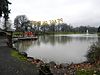 |
December 5, 1985 (#85003011) |
Bounded by Nichols and Kessler Blvds. 46°08′14″N 122°56′46″W / 46.137222°N 122.946111°W | Longview | Civic, Cultural, and Commercial Resources of Longview Thematic Resource MPS |
| 9 | Laughlin Round Barn |  |
May 15, 1986 (#86001080) |
8249 Barnes Dr. 46°20′25″N 122°55′24″W / 46.340278°N 122.923333°W | Castle Rock | Laughlin Round Bridge near Castle Rock. |
| 10 | Lawetlat'la |  |
September 11, 2013 (#13000748) |
Gifford Pinchot National Forest 46°12′49″N 122°14′39″W / 46.213576°N 122.244301°W | Cougar | Cowlitz people name for Mount St. Helens |
| 11 | Robert Alexander Long High School | 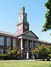 |
December 5, 1985 (#85003010) |
2903 Nichols Blvd. 46°08′27″N 122°57′15″W / 46.140833°N 122.954167°W | Longview | Built in 1927, this is the oldest high school in Longview. Civic, Cultural, and Commercial Resources of Longview Thematic Resource MPS |
| 12 | Longview Bridge |  |
July 16, 1982 (#82004208) |
Spans Columbia river 46°06′48″N 122°57′10″W / 46.113333°N 122.952778°W | Longview | Better known as the Lewis and Clark Bridge. Historic Bridges and Tunnels in Washington TR |
| 13 | Longview Civic Center Historic District |  |
December 5, 1985 (#85003012) |
Bounded by Maple St., Sixteenth Ave., Hemlock St., and Eighteenth Ave. 46°08′23″N 122°56′16″W / 46.139722°N 122.937778°W | Longview | Civic, Cultural, and Commercial Resources of Longview Thematic Resource MPS |
| 14 | Longview Community Church |  |
December 5, 1985 (#85003016) |
2323 Washington Way 46°08′03″N 122°56′55″W / 46.134167°N 122.948611°W | Longview | Civic, Cultural, and Commercial Resources of Longview Thematic Resource MPS |
| 15 | Longview Community Church-Saint Helen's Addition | 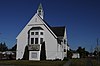 |
December 5, 1985 (#85003017) |
416 Twentieth Ave. 46°07′28″N 122°57′32″W / 46.124444°N 122.958889°W | Longview | Civic, Cultural, and Commercial Resources of Longview Thematic Resource MPS |
| 16 | Longview Community Store |  |
December 5, 1985 (#85003027) |
421 Twentieth Ave. 46°07′29″N 122°57′05″W / 46.124722°N 122.951389°W | Longview | Civic, Cultural, and Commercial Resources of Longview Thematic Resource MPS |
| 17 | Longview Women's Clubhouse | 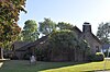 |
December 5, 1985 (#85003018) |
835 Twenty-first Ave. 46°07′55″N 122°56′52″W / 46.131990°N 122.947659°W | Longview | Civic, Cultural, and Commercial Resources of Longview Thematic Resource MPS |
| 18 | Mills Building |  |
December 5, 1985 (#85003019) |
1239 Commerce Ave. 46°08′11″N 122°56′00″W / 46.136389°N 122.933333°W | Longview | Civic, Cultural, and Commercial Resources of Longview Thematic Resource MPS |
| 19 | Nutty Narrows Bridge | 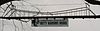 |
August 18, 2014 (#14000500) |
Spanning Olympia Way between 18th Avenue and Maple Street 46°08′29″N 122°56′26″W / 46.141469°N 122.940494°W | Longview | |
| 20 | Pacific Telephone and Telegraph Building |  |
December 5, 1985 (#85003020) |
1304 Vandercook Way 46°08′27″N 122°55′57″W / 46.140833°N 122.9325°W | Longview | Civic, Cultural, and Commercial Resources of Longview Thematic Resource MPS |
| 21 | Pounder Building |  |
December 5, 1985 (#85003021) |
1208 Commerce Ave. 46°08′10″N 122°56′01″W / 46.136111°N 122.933611°W | Longview | Civic, Cultural, and Commercial Resources of Longview Thematic Resource MPS |
| 22 | Schumann Building |  |
December 5, 1985 (#85003022) |
1233 Commerce Ave. 46°08′11″N 122°55′58″W / 46.136389°N 122.932778°W | Longview | Civic, Cultural, and Commercial Resources of Longview Thematic Resource MPS |
| 23 | Sevier and Weed Building |  |
December 5, 1985 (#85003023) |
1266 Twelfth Ave. 46°08′12″N 122°55′53″W / 46.136667°N 122.931389°W | Longview | Civic, Cultural, and Commercial Resources of Longview Thematic Resource MPS |
| 24 | Nat Smith House | 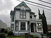 |
March 3, 1975 (#75001846) |
110 W. Grant St. 46°08′48″N 122°54′56″W / 46.146667°N 122.915556°W | Kelso | |
| 25 | Stella Blacksmith Shop |  |
December 19, 1985 (#85003204) |
8530 Ocean Beach Hwy. 46°11′30″N 123°07′13″W / 46.191667°N 123.120278°W | Stella | |
| 26 | J. D. Tennant House |  |
April 12, 1984 (#84003461) |
420 Rutherglen Rd. 46°09′06″N 122°59′30″W / 46.151667°N 122.991667°W | Longview | |
| 27 | Tyni Building | 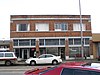 |
December 5, 1985 (#85003024) |
1166 Commerce Ave. 46°08′05″N 122°56′02″W / 46.134722°N 122.933889°W | Longview | Civic, Cultural, and Commercial Resources of Longview Thematic Resource MPS |
| 28 | U.S. Post Office – Kelso Main |  |
August 7, 1991 (#91000646) |
304 Academy St. 46°08′44″N 122°54′31″W / 46.145556°N 122.908611°W | Kelso | |
| 29 | U.S. Post Office – Longview Main | 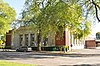 |
May 30, 1991 (#91000647) |
1603 Larch St. 46°08′17″N 122°56′16″W / 46.138056°N 122.937778°W | Longview | Civic, Cultural, and Commercial Resources of Longview Thematic Resource MPS |
| 30 | Washington Gas and Electric Building | 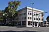 |
December 5, 1985 (#85003025) |
1346 Fourteenth Ave. 46°08′18″N 122°56′01″W / 46.138333°N 122.933611°W | Longview | Fourteenth Ave., corner of Broadway: current address 1333 Broadway. Civic, Cultural, and Commercial Resources of Longview Thematic Resource MPS |
| 31 | Willard Building |  |
December 5, 1985 (#85003026) |
1403 Twelfth Ave. 46°08′19″N 122°55′53″W / 46.138611°N 122.931389°W | Longview | Civic, Cultural, and Commercial Resources of Longview Thematic Resource MPS |
| 32 | Yale Bridge |  |
July 16, 1982 (#82004206) |
Spanning the Lewis River on State Route 503 45°57′40″N 122°22′18″W / 45.961111°N 122.371667°W | Yale | Extends into Clark County |
See also edit
References edit
- ^ Andrus, Patrick W.; Shrimpton, Rebecca H.; et al. (2002), How to Apply the National Register Criteria for Evaluation, National Register Bulletin, National Park Service, U.S. Department of the Interior, retrieved June 20, 2014.
- ^ National Park Service, National Register of Historic Places Program: Research, retrieved January 28, 2015.
- ^ Department of Archaeology and Historic Preservation, Washington Information System for Architectural and Archaeological Records Data (WISAARD), retrieved February 14, 2015.
- ^ National Park Service, United States Department of the Interior, "National Register of Historic Places: Weekly List Actions", retrieved April 12, 2024.
- ^ Numbers represent an alphabetical ordering by significant words. Various colorings, defined here, differentiate National Historic Landmarks and historic districts from other NRHP buildings, structures, sites or objects.
- ^ "National Register Information System". National Register of Historic Places. National Park Service. April 24, 2008.
- ^ The eight-digit number below each date is the number assigned to each location in the National Register Information System database, which can be viewed by clicking the number.
- ^ "National Register Information System – Civic, Cultural, and Commercial Resources of Longview Thematic Resource, a Multiple Property Submission (#64000895)". National Register of Historic Places. National Park Service. November 2, 2013.
External links edit
- Washington Department of Archaeology and Historic Preservation, Historic Register program
- National Park Service, National Register of Historic Places site
 Media related to National Register of Historic Places in Cowlitz County, Washington at Wikimedia Commons