


Summary
This is a list of the National Register of Historic Places listings in Davidson County, Tennessee.

This is intended to be a complete list of the properties and districts on the National Register of Historic Places in Davidson County, Tennessee, United States. Latitude and longitude coordinates are provided for many National Register properties and districts; these locations may be seen together in a map.[1]
There are 198 properties and districts listed on the National Register in the county, including 7 National Historic Landmarks.
See also National Register of Historic Places listings in Sumner County, Tennessee for additional properties in Goodlettsville, a city that spans the county line.
| Anderson – Bedford – Benton – Bledsoe – Blount – Bradley – Campbell – Cannon – Carroll – Carter – Cheatham – Chester – Claiborne – Clay – Cocke – Coffee – Crockett – Cumberland – Davidson – Decatur – DeKalb – Dickson – Dyer – Fayette – Fentress – Franklin – Gibson – Giles – Grainger – Greene – Grundy – Hamblen – Hamilton – Hancock – Hardeman – Hardin – Hawkins – Haywood – Henderson – Henry – Hickman – Houston – Humphreys – Jackson – Jefferson – Johnson – Knox – Lake – Lauderdale – Lawrence – Lewis – Lincoln – Loudon – Macon – Madison – Marion – Marshall – Maury – McMinn – McNairy – Meigs – Monroe – Montgomery – Moore – Morgan – Obion – Overton – Perry – Pickett – Polk – Putnam – Rhea – Roane – Robertson – Rutherford – Scott – Sequatchie – Sevier – Shelby – Smith – Stewart – Sullivan – Sumner – Tipton – Trousdale – Unicoi – Union – Van Buren – Warren – Washington – Wayne – Weakley – White – Williamson – Wilson |
This National Park Service list is complete through NPS recent listings posted April 12, 2024.[2]
Current listings edit
| [3] | Name on the Register[4] | Image | Date listed[5] | Location | City or town | Description |
|---|---|---|---|---|---|---|
| 1 | Acme Farm Supply Building |  |
April 2, 1998 (#98000320) |
101 Broadway 36°09′43″N 86°46′28″W / 36.161944°N 86.774444°W | Nashville | |
| 2 | Airdrie | September 15, 2005 (#05001027) |
3210 Avenal Ave. 36°06′11″N 86°43′54″W / 36.1031°N 86.7318°W | Nashville | ||
| 3 | Alumni Memorial Hall, Vanderbilt University |  |
July 6, 2011 (#11000418) |
2205 West End Ave. 36°08′53″N 86°48′12″W / 36.148056°N 86.803333°W | Nashville | |
| 4 | American Baptist Theological Seminary Historic District |  |
June 14, 2013 (#13000399) |
1800 Baptist World Center Dr. 36°12′09″N 86°47′24″W / 36.202599°N 86.789891°W | Nashville | |
| 5 | Archeological Site 40DV307 | March 12, 2015 (#14000940) |
Address Restricted | Nashville | ||
| 6 | Archeological Site No. 40DV35 | December 16, 1992 (#92001655) |
Cockrill Bend, 0.25 miles (0.40 km) south of the Cumberland River[6] 36°12′09″N 86°54′04″W / 36.202500°N 86.901111°W | Nashville | ||
| 7 | Beech Grove |  |
November 8, 2007 (#07001163) |
8423 Old Harding Pike 36°01′24″N 87°01′22″W / 36.0233°N 87.0229°W | Nashville | |
| 8 | Belair |  |
May 6, 1971 (#71000815) |
2250 Lebanon Rd. 36°10′09″N 86°41′15″W / 36.169167°N 86.6875°W | Nashville | |
| 9 | Belle Meade Plantation |  |
December 30, 1969 (#69000177) |
Harding Rd. at Leake Ave. 36°06′20″N 86°51′52″W / 36.105556°N 86.864444°W | Belle Meade | |
| 10 | Belle Meade Apartments |  |
April 19, 1984 (#84003474) |
715 Belle Meade Boulevard 36°05′47″N 86°51′28″W / 36.096389°N 86.857778°W | Belle Meade | |
| 11 | Belle Meade Golf Links Subdivision Historic District | July 7, 2004 (#04000675) |
Roughly bounded by Windsor Dr., Blackburn and Pembroke Aves., Westover Dr., and Harding Pl. 36°06′07″N 86°51′48″W / 36.101944°N 86.863333°W | Belle Meade | ||
| 12 | Belle Vue |  |
October 25, 1973 (#73001758) |
7306 Old Harding Rd., off U.S. Route 70S 36°04′00″N 86°56′17″W / 36.06654°N 86.93805°W | Bellevue | |
| 13 | Belmont Mansion |  |
May 6, 1971 (#71000816) |
Belmont Boulevard 36°08′09″N 86°47′41″W / 36.135833°N 86.794722°W | Nashville | |
| 14 | Belmont–Hillsboro Historic District |  |
May 1, 1980 (#80003784) |
Roughly bounded by Primrose and 20th Avenues and Magnolia and Belmont Boulevards 36°07′48″N 86°47′52″W / 36.130000°N 86.797778°W | Nashville | |
| 15 | Bennie-Dillon Building |  |
August 16, 1984 (#84003483) |
702 Church St. 36°09′44″N 86°46′59″W / 36.162222°N 86.783056°W | Nashville | |
| 16 | Berger Building |  |
November 8, 1984 (#84000376) |
164 N. 8th Ave. 36°09′39″N 86°46′59″W / 36.160786°N 86.782992°W | Nashville | |
| 17 | Bluefields Historic District | March 22, 2016 (#16000116) |
2600-2733 Bluefield Ave., 201-279 Cumberland & 2700-2724 Overhill Cirs., 104-165 Spring Valley Dr. 36°10′02″N 86°40′07″W / 36.167138°N 86.668582°W | Nashville | ||
| 18 | Brick Church Mound and Village Site |  |
May 7, 1973 (#73001759) |
East of Brick Church Pike[7] 36°14′51″N 86°46′32″W / 36.247469°N 86.775689°W | Nashville | A multi-mound Mississippian culture site, leveled in the 1970s and 80s for a residential neighborhood |
| 19 | Broadway Historic District |  |
July 18, 1980 (#80003785) |
Broadway between 2nd and 5th Aves. 36°09′40″N 86°46′38″W / 36.161111°N 86.777222°W | Nashville | |
| 20 | James Buchanan House |  |
March 29, 1984 (#84003486) |
2910 Elm Hill Pike 36°08′41″N 86°39′26″W / 36.144722°N 86.657222°W | Nashville | |
| 21 | Buena Vista Historic District |  |
April 24, 1980 (#80003786) |
Bounded by Interstate 65 and U.S. Route 41 36°10′34″N 86°47′50″W / 36.176111°N 86.797222°W | Nashville | |
| 22 | Bush-Herbert Building |  |
March 25, 1982 (#82003959) |
174 3rd. Ave., N. 36°09′49″N 86°46′38″W / 36.163611°N 86.777222°W | Nashville | |
| 23 | Cameron School |  |
March 15, 2005 (#05000180) |
1034 1st Ave., S. 36°08′55″N 86°45′51″W / 36.148611°N 86.764167°W | Nashville | |
| 24 | Cane Ridge Cumberland Presbyterian Church |  |
December 12, 1976 (#76001770) |
Southeast of Antioch on Old Hickory Boulevard 36°00′06″N 86°38′02″W / 36.001667°N 86.633889°W | Antioch | |
| 25 | Capers C.M.E. Church |  |
January 2, 1985 (#85000045) |
319 15th Ave., N. 36°09′34″N 86°47′43″W / 36.159444°N 86.795278°W | Nashville | |
| 26 | Carnegie Library |  |
January 2, 1985 (#85003769) |
17th Ave. N. on the Fisk University campus 36°10′04″N 86°48′18″W / 36.167778°N 86.805000°W | Nashville | Designed by African-American architect Moses McKissack III; built in 1908; now serves as Fisk's academic building. |
| 27 | Cartwright-Moss House | August 1, 1979 (#79002420) |
760 Old Dickerson Pike 36°18′13″N 86°43′22″W / 36.303611°N 86.722778°W | Goodlettsville | ||
| 28 | Castner-Knott Building |  |
August 20, 1999 (#99000957) |
616-618 Church St. 36°09′45″N 86°46′56″W / 36.1625°N 86.782222°W | Nashville | |
| 29 | James A. Cayce Administration Service Building |  |
December 13, 2019 (#100004689) |
701 S. 6th St. 36°09′58″N 86°45′32″W / 36.1660°N 86.7589°W | Nashville | |
| 30 | Centennial Park |  |
July 15, 2008 (#08000689) |
West End Ave. at its junction with 25th Ave. N. 36°08′59″N 86°48′47″W / 36.149589°N 86.812936°W | Nashville | |
| 31 | Robert Chadwell House |  |
November 13, 1989 (#89001972) |
712 Neeleys Bend Rd. 36°15′09″N 86°41′48″W / 36.2525°N 86.696667°W | Madison | |
| 32 | Cheatham Building |  |
February 21, 1980 (#80003787) |
301-309 Church St. 36°09′50″N 86°46′39″W / 36.163889°N 86.7775°W | Nashville | |
| 33 | Cheekwood |  |
August 23, 2000 (#00000993) |
1200 Forrest Park Dr. 36°05′11″N 86°52′26″W / 36.086339°N 86.873961°W | Nashville | |
| 34 | Christ Church |  |
November 14, 1978 (#78002577) |
900 Broadway 36°09′32″N 86°47′00″W / 36.158889°N 86.783333°W | Nashville | |
| 35 | Church of the Assumption |  |
August 22, 1977 (#77001262) |
1227 7th Ave., N. 36°10′31″N 86°47′30″W / 36.175278°N 86.791667°W | Nashville | |
| 36 | Cleveland Hall |  |
April 16, 1971 (#71000821) |
4041 Old Hickory Boulevard 36°13′46″N 86°37′38″W / 36.229444°N 86.627222°W | Old Hickory | |
| 37 | Clover Bottom Farm |  |
April 3, 1975 (#75001747) |
2941 Lebanon Rd. 36°10′11″N 86°38′58″W / 36.169722°N 86.649444°W | Donelson | Enlarged and renamed (from Clover Bottom Mansion to Clover Bottom Farm) on May 7, 2019. |
| 38 | Cole House |  |
December 27, 1974 (#74001907) |
2001 Lebanon Rd. 36°09′24″N 86°42′28″W / 36.156667°N 86.707778°W | Nashville | |
| 39 | Anna Russell Cole Auditorium |  |
April 17, 1980 (#80003788) |
Tennessee Preparatory School campus 36°07′56″N 86°44′28″W / 36.132222°N 86.741111°W | Nashville | |
| 40 | Mrs. Edward B. Craig House |  |
October 27, 2003 (#03001078) |
1418 Chickering Rd. 36°04′18″N 86°52′03″W / 36.071667°N 86.8675°W | Forest Hills | |
| 41 | Cummins Station |  |
November 17, 1983 (#83004233) |
Demonbreun and 10th Ave., S. 36°09′19″N 86°46′58″W / 36.155278°N 86.782778°W | Nashville | |
| 42 | Davidson County Courthouse |  |
March 23, 1987 (#87000670) |
Public Sq. 36°10′02″N 86°46′43″W / 36.167222°N 86.778611°W | Nashville | |
| 43 | Demonbreun's Cave | February 7, 1980 (#80003789) |
1700 Omohumdro Dr. 36°09′55″N 86°42′57″W / 36.165278°N 86.715833°W | Nashville | ||
| 44 | Devon Farm |  |
August 28, 1974 (#74001908) |
South of Nashville on State Route 100 36°03′28″N 86°55′11″W / 36.057778°N 86.919722°W | Nashville | |
| 45 | Doctor's Building |  |
July 25, 1985 (#85001607) |
706 Church St. 36°09′44″N 86°46′59″W / 36.162222°N 86.783056°W | Nashville | |
| 46 | Dozier Farm | November 1, 1990 (#90001580) |
8451 River Rd. Pike 36°12′16″N 86°58′36″W / 36.204444°N 86.976667°W | Nashville | ||
| 47 | Dubuisson-Neuhoff House |  |
October 27, 2003 (#03001077) |
1407 Chickering Rd. 36°04′24″N 86°52′01″W / 36.073333°N 86.866944°W | Forest Hills | |
| 48 | Guildford Dudley, Sr. and Anne Dallas House | October 23, 2003 (#03001080) |
5401 Hillsboro Pike 36°05′07″N 86°50′04″W / 36.085278°N 86.834444°W | Forest Hills | ||
| 49 | Arthur J. Dyer Observatory |  |
March 6, 2009 (#09000114) |
1000 Oman Dr. 36°03′08″N 86°48′17″W / 36.05213°N 86.80481°W | Brentwood | |
| 50 | East Nashville High and Junior High Schools |  |
January 25, 2002 (#01001552) |
110 and 112 Gallatin Rd. 36°10′52″N 86°45′10″W / 36.181111°N 86.752778°W | Nashville | |
| 51 | East Nashville Historic District |  |
April 15, 1982 (#82003960) |
Roughly bounded by Gallatin Pike, Edgewood Pl., N. 16th St., and Russell Sts. 36°10′39″N 86°44′42″W / 36.1775°N 86.745°W | Nashville | |
| 52 | Edgefield Historic District |  |
July 13, 1977 (#77001263) |
Roughly bounded by Woodland, S. 10th and S. 5th Sts., and Shelby Ave. 36°10′22″N 86°45′28″W / 36.172778°N 86.757778°W | Nashville | |
| 53 | Eighth Avenue South Reservoir |  |
March 30, 1978 (#78002578) |
8th Ave., S. 36°08′21″N 86°46′49″W / 36.139167°N 86.780278°W | Nashville | |
| 54 | Ellis Service Station Garage |  |
April 15, 1991 (#91000436) |
2000 Old Murfreesboro Rd. 36°05′50″N 86°39′13″W / 36.097222°N 86.653611°W | Nashville | |
| 55 | Elm Street Methodist Church |  |
May 15, 1984 (#84003496) |
616 5th Ave., S. 36°09′11″N 86°46′24″W / 36.153056°N 86.773333°W | Nashville | |
| 56 | Alexander Ewing House |  |
November 25, 1980 (#80003790) |
5101 Buena Vista Pike 36°14′03″N 86°49′38″W / 36.234167°N 86.827222°W | Nashville | |
| 57 | Exit/In |  |
March 28, 2023 (#100008789) |
2208 Elliston Pl. 36°09′05″N 86°48′15″W / 36.1514°N 86.8043°W | Nashville | |
| 58 | Fall School |  |
December 19, 1979 (#79002421) |
1116 S. 8th Ave. 36°08′32″N 86°46′43″W / 36.142222°N 86.778611°W | Nashville | |
| 59 | Federal Office Building |  |
December 26, 1972 (#72001232) |
701 Broadway 36°09′31″N 86°46′53″W / 36.158611°N 86.781389°W | Nashville | The 1877 Federal Custom House and Courthouse |
| 60 | Federal Office Building | 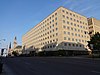 |
October 24, 2016 (#16000739) |
801 Broadway 36°09′30″N 86°46′58″W / 36.158281°N 86.782647°W | Nashville | Now known as the Estes Kefauver Federal Building and United States Courthouse. |
| 61 | Federal Reserve Bank of Atlanta |  |
October 10, 1984 (#84000089) |
226 N. 3rd Ave. 36°09′58″N 86°46′45″W / 36.166111°N 86.779167°W | Nashville | |
| 62 | Fifth Avenue Historic District |  |
December 5, 1983 (#83004234) |
Roughly bounded by Church and Union Sts. and 4th, 5th, and 6th Aves. 36°09′50″N 86°46′50″W / 36.163889°N 86.780556°W | Nashville | |
| 63 | Fire Hall No. 1 |  |
July 23, 2008 (#08000691) |
1312 3rd Ave., N. 36°10′43″N 86°47′12″W / 36.178553°N 86.786603°W | Nashville | |
| 64 | Fire Hall for Engine Company No. 18 |  |
June 24, 2016 (#16000416) |
1220 Gallatin Ave. 36°11′31″N 86°44′42″W / 36.192071°N 86.744953°W | Nashville | |
| 65 | First Baptist Church East Nashville |  |
July 27, 2005 (#05000761) |
601 Main St. 36°10′33″N 86°45′46″W / 36.175833°N 86.762778°W | Nashville | |
| 66 | First Presbyterian Church |  |
July 8, 1970 (#70000608) |
154 5th Ave., N. 36°09′46″N 86°46′47″W / 36.162778°N 86.779722°W | Nashville | |
| 67 | Fisk University Historic District |  |
February 9, 1978 (#78002579) |
Roughly bounded by 16th and 18th Aves. and Hermosa, Herman and Jefferson Sts. 36°10′04″N 86°48′17″W / 36.167778°N 86.804722°W | Nashville | |
| 68 | Fort Negley |  |
April 21, 1975 (#75001748) |
Ridley Boulevard and Chestnut St. 36°08′42″N 86°46′28″W / 36.145°N 86.774444°W | Nashville | |
| 69 | Frost Building |  |
November 25, 1980 (#80003791) |
161 8th Ave., N. 36°09′38″N 86°47′00″W / 36.160556°N 86.783333°W | Nashville | |
| 70 | James Geddes Engine Company No. 6 |  |
January 9, 1978 (#78002580) |
629 2nd Ave., S. 36°09′16″N 86°46′14″W / 36.154444°N 86.770556°W | Nashville | |
| 71 | John Geist and Sons Blacksmith Shop and House |  |
April 29, 1980 (#80003792) |
311 and 313 Jefferson St. 36°10′28″N 86°47′06″W / 36.174444°N 86.785°W | Nashville | Boundary decrease July 22, 2016 removed 309 Jefferson Street. |
| 72 | Germantown Historic District |  |
August 1, 1979 (#79002422) |
Bounded by Jefferson, Hume, Rosa Parks, and Third[8] 36°10′36″N 86°47′25″W / 36.176667°N 86.790278°W | Nashville | |
| 73 | Gilbert Mansion |  |
March 28, 1979 (#79002423) |
1906 West End Ave. 36°09′08″N 86°47′54″W / 36.152222°N 86.798333°W | Nashville | |
| 74 | Gladstone Apartments |  |
June 16, 1983 (#83003025) |
3803 West End Ave. 36°07′54″N 86°49′55″W / 36.131667°N 86.831944°W | Nashville | |
| 75 | Glen Oak |  |
November 17, 1983 (#83004235) |
2012 25th Ave., S. 36°07′57″N 86°48′24″W / 36.132500°N 86.806667°W | Nashville | |
| 76 | Grand Ole Opry House |  |
January 27, 2015 (#14001222) |
2804 Opryland Dr. 36°12′23″N 86°41′30″W / 36.2064°N 86.6917°W | Nashville | Main home of the Grand Ole Opry since 1974. |
| 77 | Grassmere |  |
July 19, 1984 (#84003503) |
Nolensville Rd. 36°05′16″N 86°44′26″W / 36.087778°N 86.740556°W | Nashville | Plantation house on the property that is now the site of the Nashville Zoo |
| 78 | Benajah Gray Log House |  |
July 11, 1985 (#85001512) |
446 Battle Rd. 35°59′36″N 86°37′31″W / 35.993333°N 86.625278°W | Antioch | |
| 79 | Gymnasium, Vanderbilt University |  |
February 23, 1972 (#72001233) |
West End and 23rd Aves. 36°08′54″N 86°48′18″W / 36.148333°N 86.805°W | Nashville | |
| 80 | Hall-Harding-McCampbell House |  |
March 23, 2010 (#10000141) |
305 Kent Rd. 36°09′32″N 86°39′43″W / 36.158881°N 86.661942°W | Nashville | |
| 81 | Hays-Kiser House |  |
September 10, 1974 (#74001906) |
834 Reeves Rd. 36°03′55″N 86°40′20″W / 36.065278°N 86.672222°W | Antioch | |
| 82 | Hermitage Hotel |  |
July 24, 1975 (#75001749) |
231 6th Ave., N. 36°09′47″N 86°47′01″W / 36.1631°N 86.7836°W | Nashville | Designated a National Historic Landmark in 2020 for its role in the women's suffrage movement. |
| 83 | The Hermitage |  |
October 15, 1966 (#66000722) |
12 miles (19 km) east of Nashville on U.S. Route 70N 36°12′54″N 86°36′42″W / 36.215°N 86.611667°W | Hermitage | |
| 84 | Hillsboro-West End Historic District |  |
December 23, 1993 (#93001435) |
Roughly bounded by West End, 31st, Blakemore, and 21st Aves. and Interstate 440 36°08′00″N 86°48′24″W / 36.133333°N 86.806667°W | Nashville | |
| 85 | Holly Street Fire Hall |  |
August 26, 1982 (#82003963) |
1600 Holly St. 36°10′30″N 86°44′30″W / 36.175°N 86.741667°W | Nashville | |
| 86 | Holy Trinity Church |  |
April 14, 1972 (#72001234) |
615 6th Ave., S. 36°09′10″N 86°46′33″W / 36.152778°N 86.775833°W | Nashville | |
| 87 | Home for Aged Masons |  |
November 19, 2008 (#08001086) |
Ben Allen Rd. and R.S. Gass Boulevard 36°13′03″N 86°44′36″W / 36.217467°N 86.743367°W | Nashville | |
| 88 | House of David Recording Studio Complex |  |
November 15, 2016 (#16000472) |
1205-1207 16th Ave., S. 36°08′35″N 86°47′36″W / 36.142928°N 86.793401°W | Nashville | |
| 89 | P. D. Houston Jr. House | October 27, 2003 (#03001081) |
5617 Hillsboro Pike 36°04′57″N 86°50′06″W / 36.0825°N 86.835°W | Forest Hills | ||
| 90 | Hows-Madden House |  |
November 23, 1984 (#84000324) |
U.S. Route 70 36°05′32″N 86°59′02″W / 36.092222°N 86.983889°W | Nashville | |
| 91 | Hubbard House |  |
August 14, 1973 (#73001760) |
1109 1st Ave., S. 36°08′48″N 86°45′50″W / 36.146667°N 86.763889°W | Nashville | |
| 92 | Hume-Fogg High School |  |
October 16, 1974 (#74001909) |
700 Broad St. 36°09′34″N 86°46′55″W / 36.159444°N 86.781944°W | Nashville | |
| 93 | Inglewood Place Historic District |  |
March 22, 2016 (#16000117) |
Golf, Greenfield, Howard, Jakes, Katherine, Kennedy, Kirkland, McChesney, Riverside, Shelton & Stratford Aves. 36°12′41″N 86°43′12″W / 36.211515°N 86.720023°W | Nashville | |
| 94 | Jackson Park Historic District |  |
July 26, 2016 (#16000483) |
Brush Hill Ct., Brush Hill Rd., Earlene, Kenwood, Riverwood & E. Riverwood Drs., Eastdale & Plymouth Aves. 36°13′14″N 86°42′41″W / 36.220422°N 86.711459°W | Nashville | |
| 95 | Jubilee Hall, Fisk University |  |
December 9, 1971 (#71000817) |
17th Ave., N. 36°10′08″N 86°48′17″W / 36.168889°N 86.804722°W | Nashville | |
| 96 | Thomas P. Kennedy Jr. House | October 27, 2003 (#03001079) |
6231 Hillsboro Pike 36°03′21″N 86°51′31″W / 36.055833°N 86.858611°W | Forest Hills | ||
| 97 | Kenner Manor Historic District | May 26, 2016 (#16000118) |
672-910 Clearview Dr., 700-722 Crescent Rd., 100-201 Kenner Ave., 200-313 Woodmont Cir. 36°07′08″N 86°50′19″W / 36.118769°N 86.838636°W | Nashville | ||
| 98 | Lakewood Commercial District | May 24, 1985 (#85001556) |
Roughly bounded by 22nd St. and Old Hickory Boulevard 36°14′55″N 86°38′32″W / 36.248611°N 86.642222°W | Lakewood | ||
| 99 | Lebanon Road Stone Arch Bridge |  |
May 13, 1987 (#87000379) |
Over Brown's Creek at Lebanon Rd. 36°09′16″N 86°44′33″W / 36.154444°N 86.7425°W | Nashville | |
| 100 | Lindsley Avenue Church of Christ |  |
May 15, 1984 (#84003507) |
3 Lindsley Ave. 36°09′08″N 86°46′07″W / 36.152222°N 86.768611°W | Nashville | |
| 101 | Litterer Laboratory |  |
January 9, 1978 (#78002581) |
631 2nd Ave., S. 36°09′15″N 86°46′13″W / 36.154167°N 86.770278°W | Nashville | |
| 102 | Little Sisters of the Poor Home for the Aged |  |
July 25, 1985 (#85001608) |
1400 18th Ave., S. 36°08′26″N 86°47′44″W / 36.140556°N 86.795556°W | Nashville | |
| 103 | Longleat | February 16, 1984 (#84003509) |
5819 Hillsboro Rd. 36°04′37″N 86°50′27″W / 36.076944°N 86.840833°W | Nashville | ||
| 104 | Longview |  |
January 12, 1983 (#83003027) |
811 Caldwell Lane 36°06′22″N 86°46′33″W / 36.106004°N 86.775706°W | Nashville | |
| 105 | Hulda Margaret Lyttle Hall of Meharry Medical College |  |
July 27, 1998 (#98000842) |
1005 Dr. D. B. Todd, Jr., Boulevard 36°10′02″N 86°48′18″W / 36.167222°N 86.805°W | Nashville | |
| 106 | Marathon Motor Works |  |
January 4, 1996 (#95001482) |
1200–1310 and 1305 Clinton St. 36°09′53″N 86°47′44″W / 36.164722°N 86.795556°W | Nashville | |
| 107 | Dr. Richard and Mrs. Margaret Martin House |  |
March 22, 2007 (#07000188) |
825 Kendall Dr. 36°08′02″N 86°51′53″W / 36.133889°N 86.864722°W | Nashville | |
| 108 | Richard E. Martin House | October 27, 2003 (#03001083) |
30 Castlewood Court 36°04′22″N 86°50′43″W / 36.072778°N 86.845278°W | Forest Hills | ||
| 109 | McCrory-Mayfield House |  |
December 27, 1982 (#82001726) |
1280 Old Hickory Boulevard 36°02′31″N 86°49′41″W / 36.041944°N 86.828056°W | Brentwood | |
| 110 | McGavock-Gatewood-Webb House |  |
July 11, 2007 (#07000688) |
908 Meridian St. 36°11′15″N 86°46′07″W / 36.1875°N 86.768611°W | Nashville | |
| 111 | Mechanical Engineering Hall, Vanderbilt University |  |
December 13, 1978 (#78002582) |
Grand Ave. and 21st Ave., S. 36°08′50″N 86°48′00″W / 36.147222°N 86.8°W | Nashville | |
| 112 | Miles House |  |
January 8, 1979 (#79002424) |
631 Woodland St. 36°10′25″N 86°45′38″W / 36.173611°N 86.760556°W | Nashville | |
| 113 | Dr. Cleo Miller House |  |
August 25, 1995 (#95001045) |
1431 Shelton Ave. 36°12′37″N 86°43′14″W / 36.210258°N 86.720442°W | Nashville | |
| 114 | Morris Memorial Building |  |
January 2, 1985 (#85000046) |
330 Charlotte Ave. 36°10′01″N 86°46′49″W / 36.166944°N 86.780278°W | Nashville | |
| 115 | Mount Olivet Cemetery |  |
November 25, 2005 (#05001334) |
1101 Lebanon Pike 36°09′02″N 86°43′58″W / 36.150556°N 86.732778°W | Nashville | |
| 116 | Municipal Public Works Garage Industrial District |  |
November 29, 2010 (#10000949) |
33 Peabody St. 36°09′28″N 86°46′06″W / 36.157778°N 86.768333°W | Nashville | |
| 117 | Nashville Arcade |  |
May 22, 1973 (#73001761) |
Between 4th and 5th Aves. 36°09′51″N 86°46′48″W / 36.164167°N 86.78°W | Nashville | |
| 118 | Nashville Children's Museum |  |
May 6, 1971 (#71000818) |
724 2nd Ave., S. 36°09′15″N 86°46′05″W / 36.154167°N 86.768056°W | Nashville | Originally the University of Nashville, Literary Department Building. Begun in 1853; architect was Major Adolphus Heiman of Nashville.[9] |
| 119 | Nashville Christian Institute Gymnasium |  |
March 10, 2005 (#05000181) |
2420 Batavia St. 36°09′40″N 86°48′47″W / 36.161111°N 86.813056°W | Nashville | |
| 120 | Nashville City Cemetery |  |
October 18, 1972 (#72001235) |
1001 S. 4th Ave. 36°08′51″N 86°46′12″W / 36.1475°N 86.77°W | Nashville | |
| 121 | Nashville Financial Historic District |  |
March 20, 2002 (#02000232) |
3rd Ave., N. and Union St. 36°09′56″N 86°46′42″W / 36.165556°N 86.778333°W | Nashville | |
| 122 | Nashville National Cemetery |  |
December 20, 1996 (#96001516) |
1420 Gallatin Rd., S 36°14′28″N 86°43′35″W / 36.241111°N 86.726389°W | Nashville | |
| 123 | Nashville Union Station and Trainshed |  |
December 30, 1969 (#69000178) |
Broadway and 10th Ave. 36°09′24″N 86°47′04″W / 36.156667°N 86.784444°W | Nashville | |
| 124 | Newsom's Mill |  |
September 13, 1976 (#76001771) |
West of Nashville on the Big Harpeth River 36°04′49″N 86°59′47″W / 36.080278°N 86.996389°W | Nashville | |
| 125 | Noel Hotel |  |
October 10, 1984 (#84000090) |
200-204 N. 4th Ave. 36°09′50″N 86°46′46″W / 36.163889°N 86.779444°W | Nashville | |
| 126 | Oglesby School |  |
November 15, 2002 (#02001340) |
5724 Edmondson Pike 36°02′15″N 86°44′34″W / 36.0375°N 86.742778°W | Nashville | |
| 127 | Old Hickory Historic District | May 24, 1985 (#85001555) |
Bordered by Hadley Ave., Jones St., 8th St., Riverside Dr. and 15th Ave. 36°15′32″N 86°38′42″W / 36.258889°N 86.645°W | Old Hickory | ||
| 128 | Old Hickory Methodist Church |  |
May 24, 1985 (#85001557) |
1216 Hadley Ave. 36°15′28″N 86°38′52″W / 36.257778°N 86.647778°W | Old Hickory | |
| 129 | Old Natchez Trace |  |
May 30, 1975 (#75002125) |
From the Alabama/Tennessee border to State Route 100 in Davidson County Coordinates missing | Nashville | Extends into Hickman, Lawrence, Lewis, Maury, Wayne, and Williamson counties |
| 130 | Omohundro Water Filtration Complex District |  |
May 13, 1987 (#87000380) |
Northeast of Omohundro Dr. 36°09′43″N 86°43′23″W / 36.161944°N 86.723056°W | Nashville | |
| 131 | Overbrook |  |
March 29, 1984 (#84003511) |
4218 Harding Rd. 36°07′55″N 86°50′35″W / 36.131944°N 86.843056°W | Nashville | |
| 132 | Overton Lane |  |
July 17, 1980 (#80003795) |
Kirkman Lane 36°05′12″N 86°48′01″W / 36.086667°N 86.800278°W | Oak Hill | |
| 133 | Park-Elkins Historic District |  |
November 15, 2011 (#11000806) |
Roughly along Park & Elkins between 42nd & 50th Aves. 36°09′02″N 86°50′32″W / 36.150517°N 86.842097°W | Nashville | |
| 134 | The Parthenon |  |
February 23, 1972 (#72001236) |
Centennial Park 36°08′59″N 86°48′49″W / 36.149722°N 86.813611°W | Nashville | |
| 135 | Peabody College for Teachers |  |
October 15, 1966 (#66000723) |
21st Ave., S. and Edgehill Ave. 36°08′30″N 86°47′55″W / 36.141667°N 86.798611°W | Nashville | |
| 136 | Pearl High School |  |
August 2, 2002 (#02000828) |
613 17th Ave., N. 36°09′43″N 86°48′01″W / 36.161944°N 86.800278°W | Nashville | |
| 137 | Thomas W. Phillips Memorial |  |
November 9, 2006 (#06001036) |
1101 19th Ave., S. 36°08′44″N 86°47′52″W / 36.145556°N 86.797778°W | Nashville | |
| 138 | Dr. Cobb Pilcher House |  |
October 27, 2003 (#03001082) |
5335 Stanford Dr. 36°04′55″N 86°49′37″W / 36.081944°N 86.826944°W | Forest Hills | |
| 139 | Primitive Baptist Church |  |
May 15, 1984 (#84003513) |
627-629 3rd Ave., S. 36°09′15″N 86°46′19″W / 36.154167°N 86.771944°W | Nashville | |
| 140 | Printers Alley Historic District |  |
August 26, 1982 (#82003964) |
Roughly bounded by 3rd and 4th Aves., Bank Alley, and both sides of Church St. 36°09′51″N 86°46′43″W / 36.164167°N 86.778611°W | Nashville | |
| 141 | RCA Studio B |  |
July 10, 2012 (#12000420) |
1611 Roy Acuff Pl. 36°09′00″N 86°47′34″W / 36.149996°N 86.792863°W | Nashville | |
| 142 | RCA Victor Studios Building |  |
July 21, 2015 (#15000445) |
30 Music Square W. 36°08′59″N 86°47′35″W / 36.1497°N 86.7931°W | Nashville | |
| 143 | Rainbow Ranch |  |
November 27, 2018 (#100003154) |
312 E Marthona Rd. 36°15′38″N 86°43′40″W / 36.2606°N 86.7277°W | Nashville | |
| 144 | Rich-Schwartz Building |  |
October 10, 1984 (#84000091) |
202-204 N. 6th Ave. 36°09′47″N 86°46′56″W / 36.163056°N 86.782222°W | Nashville | |
| 145 | Richland Hall |  |
September 1, 1983 (#83003028) |
4822 Charlotte Ave. 36°09′08″N 86°50′45″W / 36.152222°N 86.845833°W | Nashville | |
| 146 | Richland-West End Historic District |  |
April 16, 1979 (#79002425) |
Roughly bounded by railroad tracks, Murphy Rd., and Park Circle, Wilson, and Richland Aves. 36°08′09″N 86°49′50″W / 36.135833°N 86.830556°W | Nashville | |
| 147 | Riverwood |  |
July 20, 1977 (#77001264) |
1833 Welcome Lane 36°12′N 86°43′W / 36.2°N 86.71°W | Nashville | |
| 148 | James Robertson Hotel |  |
October 10, 1984 (#84000092) |
118 N. 7th Ave. 36°09′37″N 86°46′54″W / 36.160278°N 86.781667°W | Nashville | |
| 149 | Robincroft |  |
July 10, 1978 (#78002583) |
746 Benton Ave. 36°07′58″N 86°46′35″W / 36.132639°N 86.776389°W | Nashville | |
| 150 | Rutledge Hill Historic District |  |
July 8, 1980 (#80003793) |
Roughly bounded by Middleton, 2nd, Lea, and Hermitage Aves. 36°09′19″N 86°46′09″W / 36.155278°N 86.769167°W | Nashville | |
| 151 | Ryman Auditorium |  |
May 6, 1971 (#71000819) |
116 5th Ave., N. 36°09′39″N 86°46′44″W / 36.160833°N 86.778889°W | Nashville | |
| 152 | St. Ann's Episcopal Church |  |
November 18, 1983 (#83004237) |
419 Woodland St. 36°10′18″N 86°45′56″W / 36.171667°N 86.765556°W | Nashville | |
| 153 | St. Cecilia Academy |  |
December 12, 1976 (#76001772) |
8th Ave. and Clay St. 36°11′13″N 86°48′04″W / 36.186944°N 86.801111°W | Nashville | |
| 154 | St. Mary's Catholic Church |  |
July 8, 1970 (#70000609) |
330 5th Ave., N. 36°09′57″N 86°46′53″W / 36.165833°N 86.781389°W | Nashville | |
| 155 | St. Patrick's Catholic Church and Rectory |  |
May 15, 1984 (#84003516) |
1219 2nd Ave., S. 36°08′39″N 86°45′51″W / 36.144167°N 86.764167°W | Nashville | |
| 156 | Sandbar Village | July 22, 1994 (#94000749) |
Both sides of the Cumberland River, northwest of Nashville[10] 36°12′20″N 86°53′52″W / 36.205556°N 86.897778°W | Nashville | ||
| 157 | Savage House |  |
January 11, 1983 (#83003029) |
167 8th Ave., N. 36°09′39″N 86°47′01″W / 36.160833°N 86.783611°W | Nashville | |
| 158 | Scarritt College Historic District |  |
August 26, 1982 (#82003965) |
19th Ave., S. 36°08′46″N 86°47′48″W / 36.146111°N 86.796667°W | Nashville | |
| 159 | Second Avenue Commercial District |  |
February 23, 1972 (#72001237) |
2nd Ave. between Brandon St. and Broadway 36°09′50″N 86°46′35″W / 36.163889°N 86.776389°W | Nashville | |
| 160 | Abner T. Shaw House |  |
March 28, 1985 (#85000671) |
4866 Brick Church Pike 36°18′53″N 86°46′38″W / 36.314722°N 86.777222°W | Goodlettsville | |
| 161 | Shelby Street Bridge |  |
November 20, 1986 (#86003237) |
Over the Cumberland River at Shelby St. 36°09′43″N 86°46′19″W / 36.161944°N 86.771944°W | Nashville | |
| 162 | Smith Farmhouse |  |
November 17, 1983 (#83004239) |
State Route 100; also 8600 State Route 100, north and west of the original boundaries 36°02′07″N 86°58′52″W / 36.03525°N 86.9812°W | Pasquo | 8600 State Route 100 represents a boundary increase of June 24, 1991 |
| 163 | Smith-Carter House |  |
November 29, 2018 (#100003155) |
1020 Gibson Dr. 36°15′06″N 86°43′25″W / 36.2517°N 86.7236°W | Madison | |
| 164 | Southern Methodist Publishing House |  |
September 13, 1984 (#84003519) |
810 Broadway 36°09′33″N 86°46′58″W / 36.159111°N 86.782861°W | Nashville | |
| 165 | Stone Hall |  |
November 17, 2010 (#10000923) |
1014 Stones River Rd. 36°11′16″N 86°37′58″W / 36.187778°N 86.632778°W | Nashville | |
| 166 | Frederick Stump House |  |
April 2, 1973 (#73001762) |
4949 Buena Vista Pike 36°13′22″N 86°49′31″W / 36.222778°N 86.825278°W | Nashville | |
| 167 | Sunnyside | 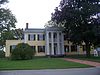 |
October 1, 1974 (#74001910) |
3000 Granny White Pike 36°07′09″N 86°47′20″W / 36.119167°N 86.788889°W | Nashville | |
| 168 | Tanglewood Historic District | July 20, 1998 (#98000819) |
4907, 4909, and 4911 Tanglewood Dr.; also 4905 Tanglewood Dr. 36°14′07″N 86°43′02″W / 36.2354°N 86.717233°W | Nashville | 4905 Tanglewood represents a boundary increase of March 19, 1999 | |
| 169 | Temple Cemetery |  |
May 12, 2004 (#04000440) |
2001 15th Ave. N 36°11′09″N 86°48′41″W / 36.185833°N 86.811389°W | Nashville | |
| 170 | Tennessee Manufacturing Company |  |
June 25, 1999 (#99000759) |
1400 8th Ave., N. 36°10′43″N 86°47′32″W / 36.178611°N 86.792222°W | Nashville | |
| 171 | Tennessee State Capitol | 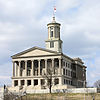 |
July 8, 1970 (#70000894) |
Capitol Hill 36°09′57″N 86°47′03″W / 36.165833°N 86.784167°W | Nashville | |
| 172 | Tennessee State Library and Archives | 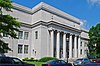 |
November 17, 2003 (#03001154) |
403 7th Ave., N. 36°09′56″N 86°47′07″W / 36.165556°N 86.785278°W | Nashville | |
| 173 | Tennessee State Office Building |  |
July 13, 2011 (#11000455) |
6th Ave., N. & Charlotte Ave. 36°09′58″N 86°46′57″W / 36.166111°N 86.7825°W | Nashville | |
| 174 | Tennessee State University Historic District |  |
June 14, 1996 (#96000677) |
3500 John A. Merritt Boulevard 36°10′00″N 86°49′48″W / 36.166667°N 86.83°W | Nashville | |
| 175 | Tennessee Supreme Court Building |  |
March 18, 2014 (#14000084) |
401 7th Ave., N. 36°09′54″N 86°47′05″W / 36.16493°N 86.784859°W | Nashville | |
| 176 | Tennessee War Memorial |  |
November 16, 2017 (#100001822) |
301 6th Ave. N 36°09′51″N 86°47′02″W / 36.164272°N 86.783894°W | Nashville | |
| 177 | Third Baptist Church |  |
October 31, 1979 (#79002427) |
906 and 908 Monroe St. 36°10′30″N 86°47′43″W / 36.175°N 86.795278°W | Nashville | |
| 178 | Travellers' Rest |  |
December 30, 1969 (#69000179) |
Franklin Rd. 36°04′37″N 86°45′49″W / 36.076950°N 86.763687°W | Nashville | |
| 179 | Tulip Grove |  |
February 26, 1970 (#70000607) |
Lebanon Rd. 36°12′45″N 86°36′21″W / 36.2125°N 86.605833°W | Hermitage | |
| 180 | Two Rivers |  |
February 23, 1972 (#72001238) |
3130 McGavock Pike 36°11′23″N 86°40′39″W / 36.189722°N 86.6775°W | Nashville | |
| 181 | US Post Office |  |
November 15, 1984 (#84000580) |
901 Broadway 36°09′28″N 86°47′02″W / 36.157778°N 86.783889°W | Nashville | |
| 182 | U.S. Naval Reserve Training Center |  |
July 6, 2011 (#11000419) |
1515 Davidson St. 36°09′52″N 86°44′27″W / 36.164444°N 86.740833°W | Nashville | |
| 183 | US Post Office-Old Hickory | 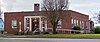 |
August 6, 1985 (#85002401) |
1010 Donelson Ave. 36°15′49″N 86°39′02″W / 36.263611°N 86.650556°W | Old Hickory | |
| 184 | Utopia Hotel |  |
March 26, 1979 (#79002428) |
206 4th Ave., N. 36°09′50″N 86°46′44″W / 36.164000°N 86.778889°W | Nashville | |
| 185 | Warner Park Historic Park |  |
January 20, 1984 (#84003528) |
Roughly bounded by the Little Harpeth River, Belle Meade Boulevard, State Route 100, and Chickering Rd. 36°03′47″N 86°53′30″W / 36.063056°N 86.891667°W | Nashville | Extends into Williamson County |
| 186 | Waverly Place Historic District |  |
March 28, 1985 (#85000676) |
Roughly bounded by Beech, Douglas, and Bradford Aves., 10th Ave., S., and Acklen Ave. 36°07′51″N 86°46′56″W / 36.130833°N 86.782222°W | Nashville | |
| 187 | Weakley-Truett-Clark House |  |
April 13, 1989 (#89000297) |
415 Rosebank Ave. 36°11′15″N 86°43′14″W / 36.1875°N 86.720556°W | Nashville | |
| 188 | West End High School | 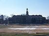 |
August 1, 2003 (#03000726) |
3529 West End Ave. 36°07′54″N 86°49′26″W / 36.131667°N 86.823889°W | Nashville | |
| 189 | West Meade |  |
March 4, 1975 (#75001750) |
Old Harding Pike 36°05′51″N 86°52′39″W / 36.0976°N 86.8774°W | Nashville | |
| 190 | Whites Creek Historic District |  |
August 16, 1984 (#84003530) |
Whites Creek Pike and Old Hickory Boulevard 36°15′32″N 86°49′43″W / 36.258889°N 86.828611°W | Whites Creek | |
| 191 | Whitland Area Neighborhood |  |
July 24, 2007 (#07000763) |
Roughly bounded by Whitland Ave., Bowling Ave., S. Wilson Boulevard, and a tributary of Richland Creek. 36°07′45″N 86°49′44″W / 36.129167°N 86.828889°W | Nashville | |
| 192 | Wilkinson House |  |
November 29, 2006 (#06001095) |
7663 Wilkinson Rd. 36°20′53″N 86°51′10″W / 36.3480°N 86.8528°W | Joelton | Residence built in 1932, designed by architect Clarence Kelley Colley. |
| 193 | Woman's Club of Nashville (J.B. Daniel House) |  |
July 19, 2010 (#10000481) |
3206 Hillsboro Pike 36°07′06″N 86°48′32″W / 36.118333°N 86.808889°W | Nashville | |
| 194 | Woodland in Waverly Historic District |  |
March 25, 1982 (#82003966) |
Roughly bounded by Interstate 65, 8th, Bradford and Wedgewood Aves. 36°07′54″N 86°46′38″W / 36.131667°N 86.777222°W | Nashville | |
| 195 | Woodlawn |  |
November 21, 1978 (#78002584) |
127 Woodmont Boulevard 36°07′19″N 86°50′43″W / 36.121944°N 86.845278°W | Nashville | |
| 196 | Woodmont Terrace Apartments |  |
April 21, 2003 (#03000280) |
920 Woodmont Blvd. 36°06′41″N 86°47′00″W / 36.11135°N 86.783431°W | Nashville | |
| 197 | Young Women's Christian Association Building | 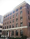 |
December 16, 1982 (#82001727) |
211 7th Ave., N. 36°09′46″N 86°47′00″W / 36.162778°N 86.783333°W | Nashville |
Former listings edit
| [3] | Name on the Register | Image | Date listed | Date removed | Location | City or town | Description |
|---|---|---|---|---|---|---|---|
| 1 | DuPont Fire Hall | May 24, 1985 (#85001558) | December 10, 2002 | 1010 Hadley Avenue | Old Hickory | ||
| 2 | Evergreen Place | April 15, 1982 (#82003961) | March 26, 2008 | 1023 Joyce Lane | Nashville | Demolished on September 22, 2005.[11] | |
| 3 | Fort Nashborough |  |
July 13, 2011 (#11000454) | November 24, 2015 | Riverfront Park on 1st Ave. 36°09′51″N 86°46′32″W / 36.164167°N 86.775556°W | Nashville | A replica of the original Fort Nashborough, built in the 1930s. Damaged in 2010 flooding. Demolished in June 2015.[12] |
| 4 | Goodwill Manor | March 25, 1982 (#82003962) | October 11, 1994 | 3500 Centennial Boulevard | Nashville | ||
| 5 | The Hibbettage | October 30, 1998 (#98001305) | April 12, 2022 | 2160 Old Hickory Boulevard 36°03′04″N 86°51′55″W / 36.051111°N 86.865278°W | Nashville | Demolished in June 2020[13] | |
| 6 | J. S. Reeves and Company Building |  |
February 1, 1972 (#72001543) | June 2, 1975 | 208-210 Public Sq. | Hickory | Also known as the Morgan-Reeves Building. Demolished in 1975.[14] |
| 7 | Hatch Show Print Company Building | June 16, 1982 (#83003026) | October 11, 1994 | 116-118 4th Avenue | Nashville | ||
| 8 | Shute-Turner House | September 11, 1997 (#97001138) | March 22, 2002 | 4112 Brandywine Point Blvd 36°14′13″N 86°36′19″W / 36.237028°N 86.60533°W | Nashville | House still exists. Removed due to alterations[15] | |
| 9 | Sudekum Building | December 19, 1979 (#79002426) | October 11, 1994 | 535 Church Street | Nashville | ||
| 10 | Treppard-Baldwin House | October 28, 1983 (#83004242) | October 11, 1994 | 3338 Whites Creek Pike | Nashville | ||
| 11 | Turner-Cole House | November 25, 1980 (#80003794) | December 5, 1986 | 2122 West End Ave. | Nashville | Demolished in 1986. | |
| 12 | Westboro Apartments | November 10, 1988 (#88002607) | March 27, 1989 | 3101 West End Ave. | Nashville | Removed due to procedural error with the nomination. |
See also edit
References edit
- ^ The latitude and longitude information provided in this table was derived originally from the National Register Information System, which has been found to be fairly accurate for about 99% of listings. Some locations in this table may have been corrected to current GPS standards.
- ^ National Park Service, United States Department of the Interior, "National Register of Historic Places: Weekly List Actions", retrieved April 12, 2024.
- ^ a b Numbers represent an alphabetical ordering by significant words. Various colorings, defined here, differentiate National Historic Landmarks and historic districts from other NRHP buildings, structures, sites or objects.
- ^ "National Register Information System". National Register of Historic Places. National Park Service. April 24, 2008.
- ^ The eight-digit number below each date is the number assigned to each location in the National Register Information System database, which can be viewed by clicking the number.
- ^ Moore, Michael C., et al. "Archaeological Investigations at 40DV35: A Multicomponent Site in the Cumberland River Valley, Davidson County, Tennessee". Tennessee Anthropologist 17.1 (1992): 54-78: 55.
- ^ Barker, Gary, and Carl Kuttruff. "A Summary of Exploratory and Salvage Archaeological Investigations at the Brick Church Mound Site (40DV39), Davidson County, Tennessee". Tennessee Archaeology 5.1 (2010): 5-30: 17.
- ^ Per the Historic Germantown website Archived 2010-04-13 at the Wayback Machine. NRIS gives location as "Off Interstate 40 and U.S. Route 41"
- ^ "University of Nashville, Literary Department Building, 724 Second Avenue, North, Nashville, Davidson County, TN". Historic American Buildings Survey, Engineering Record. Library of Congress.
- ^ Smith, Kevin E., and Michael C. Moore. "Changing Interpretations of Sandbar Village (40DV36): Mississippian Hamlet, Village, or Mound Center?" Tennessee Archaeology 6.1-2 (2012): 105-138: 106.
- ^ "Developer warned in time to halt demolition at Reeves site, develop says". The Tennessean. October 5, 2005. p. A1. Retrieved August 27, 2022 – via Newspapers.com.
- ^ "Demolition begins on Fort Nashborough". The Tennessean. June 20, 2015. p. 5A. Retrieved August 27, 2022 – via Newspapers.com.
- ^ "NRHP continuation sheet" (PDF).
- ^ "Soon To Come Tumbling Down". The Tennessean. January 18, 1975. p. 2. Retrieved August 27, 2022 – via Newspapers.com.
- ^ "Removal of plantation home from historic register irks heir". The Tennessean. September 24, 2002. p. 5M. Retrieved April 16, 2022 – via Newspapers.com.