


Summary
This is a list of the National Register of Historic Places listings in Daviess County, Indiana.
This is intended to be a complete list of the properties and districts on the National Register of Historic Places in Daviess County, Indiana, United States. Latitude and longitude coordinates are provided for many National Register properties and districts; these locations may be seen together in a map.[1]
There are 13 properties and districts listed on the National Register in the county.
Properties and districts located in incorporated areas display the name of the municipality, while properties and districts in unincorporated areas display the name of their civil township. Properties and districts split between multiple jurisdictions display the names of all jurisdictions.
This National Park Service list is complete through NPS recent listings posted April 12, 2024.[2]
Current listings edit
| [3] | Name on the Register[4] | Image | Date listed[5] | Location | City or town | Description |
|---|---|---|---|---|---|---|
| 1 | Magnus J. Carnahan House |  |
August 29, 1991 (#91001167) |
511 E. Main St. 38°39′23″N 87°10′11″W / 38.656389°N 87.169722°W | Washington | |
| 2 | County Bridge No. 45 |  |
September 20, 2006 (#06000856) |
Carries County Road 150N over the White River, northeast of Wheatland 38°40′47″N 87°16′20″W / 38.679722°N 87.272222°W | Washington Township | Extends into Knox County |
| 3 | Daviess County Courthouse |  |
September 17, 2008 (#08000916) |
200 E. Walnut St. 38°39′32″N 87°10′22″W / 38.658889°N 87.172778°W | Washington | |
| 4 | Thomas Faith House | 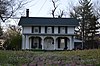 |
March 28, 1994 (#94000227) |
1208 Bedford Rd. 38°39′38″N 87°09′40″W / 38.660556°N 87.161111°W | Washington | |
| 5 | Glendale Ridge Archaeological Site (12 Da 86) | 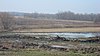 |
May 30, 1985 (#85001165) |
Address Restricted | Harrison Township | |
| 6 | Robert C. Graham House | 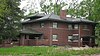 |
March 16, 1983 (#83000120) |
101 W. Maple St. 38°39′43″N 87°10′42″W / 38.661944°N 87.178333°W | Washington | |
| 7 | Jefferson Elementary School |  |
June 20, 1997 (#97000597) |
381 W 150 S 38°38′03″N 87°10′22″W / 38.634167°N 87.172778°W | Washington Township | |
| 8 | McCall Family Farmstead |  |
September 18, 2013 (#13000721) |
4914 E800N, southeast of Plainville 38°46′22″N 87°04′32″W / 38.772778°N 87.075556°W | Bogard Township | |
| 9 | Old Union Church and Cemetery |  |
June 17, 2005 (#05000605) |
1125E, approximately 3/8 miles south of its junction with 700S, south of Alfordsville 38°32′56″N 86°57′22″W / 38.548889°N 86.956111°W | Reeve Township | |
| 10 | Prairie Creek Site |  |
May 12, 1975 (#75000013) |
Southeastern bank of Prairie Creek, 1.5 kilometres (0.93 mi) below the western edge of the Thousand Acre Woods and north of Washington[6] 38°43′04″N 87°09′55″W / 38.717778°N 87.165278°W | Washington Township | |
| 11 | Dr. John A. Scudder House |  |
September 14, 1995 (#95001104) |
612 E. Main St. 38°39′26″N 87°10′05″W / 38.657222°N 87.168056°W | Washington | |
| 12 | Washington Commercial Historic District |  |
November 28, 1990 (#90001780) |
Roughly bounded by 4th, Hefron, and Meridian Sts. and the CSX railroad line 38°39′27″N 87°10′22″W / 38.6575°N 87.172778°W | Washington | |
| 13 | Dr. Nelson Wilson House |  |
June 26, 2008 (#08000566) |
103 E. National Highway 38°39′09″N 87°10′29″W / 38.652611°N 87.174611°W | Washington |
See also edit
References edit
- ^ The latitude and longitude information provided in this table was derived originally from the National Register Information System, which has been found to be fairly accurate for about 99% of listings. Some locations in this table may have been corrected to current GPS standards.
- ^ National Park Service, United States Department of the Interior, "National Register of Historic Places: Weekly List Actions", retrieved April 12, 2024.
- ^ Numbers represent an alphabetical ordering by significant words. Various colorings, defined here, differentiate National Historic Landmarks and historic districts from other NRHP buildings, structures, sites or objects.
- ^ "National Register Information System". National Register of Historic Places. National Park Service. March 13, 2009.
- ^ The eight-digit number below each date is the number assigned to each location in the National Register Information System database, which can be viewed by clicking the number.
- ^ Location derived from Tomak, Curtis H. "Prairie Creek: A Stratified Site in Southwestern Indiana." Proceedings of the Indiana Academy of Science 84 (1974): 65-68. The NRIS lists the site as "Address Restricted".