
KNOWPIA
WELCOME TO KNOWPIA

National Register of Historic Places listings in Delta County, Colorado 
Summary
This is a list of the National Register of Historic Places listings in Delta County, Colorado.

This is intended to be a complete list of the properties and districts on the National Register of Historic Places in Delta County, Colorado, United States. The locations of National Register properties and districts for which the latitude and longitude coordinates are included below, may be seen in a map.[1]
There are 17 properties and districts listed on the National Register in the county. Another 4 properties were once listed but have been removed.
This National Park Service list is complete through NPS recent listings posted April 12, 2024.[2]
Current listings edit
| [3] | Name on the Register[4] | Image | Date listed[5] | Location | City or town | Description |
|---|---|---|---|---|---|---|
| 1 | Bross Hotel | 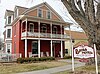 |
November 16, 2015 (#15000780) |
312 Onarga Ave. 38°52′08″N 107°35′48″W / 38.8689°N 107.5966°W | Paonia | |
| 2 | Curtis Hardware Store |  |
October 19, 1989 (#89001746) |
228 Grand Ave. 38°52′05″N 107°35′52″W / 38.868056°N 107.597778°W | Paonia | |
| 3 | Delta County Bank Building | 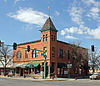 |
June 24, 1993 (#93000577) |
301 and 305 Main St. 38°44′34″N 108°04′14″W / 38.742778°N 108.070556°W | Delta | |
| 4 | Delta Municipal Light & Power Plant | March 18, 2024 (#100010079) |
1133 Main St. 38°43′55″N 108°04′15″W / 38.7319°N 108.0709°W | Delta | ||
| 4 | Egyptian Theater | 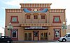 |
July 12, 1993 (#93000575) |
452 Main St. 38°44′27″N 108°04′11″W / 38.740833°N 108.069722°W | Delta | |
| 5 | Ferganchick Orchard Rock Art Site | May 9, 1983 (#83001304) |
Address Restricted | Austin | ||
| 6 | First Methodist Episcopal Church of Delta | 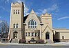 |
February 20, 1991 (#91000069) |
199 E. 5th St. 38°44′25″N 108°04′09″W / 38.740278°N 108.069167°W | Delta | |
| 7 | First Presbyterian Church of Eckert |  |
January 11, 2006 (#05001507) |
13011 and 13025 State Highway 65 38°49′42″N 107°58′14″W / 38.828333°N 107.970556°W | Eckert | |
| 8 | Garnethurst | 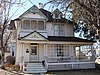 |
November 7, 1995 (#95001245) |
509 Leon St. 38°44′25″N 108°03′45″W / 38.740278°N 108.0625°W | Delta | |
| 9 | Hotchkiss Homestead |  |
December 15, 2011 (#11000900) |
422 Riverside Dr. 38°47′59″N 107°43′55″W / 38.7997°N 107.732°W | Hotchkiss | |
| 10 | Hotchkiss Hotel |  |
September 20, 1984 (#84000802) |
101 Bridge St. 38°47′57″N 107°43′09″W / 38.799167°N 107.719167°W | Hotchkiss | |
| 11 | Hotchkiss Methodist Episcopal Church | 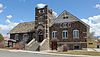 |
October 28, 2009 (#09000853) |
285 N. 2nd St. 38°47′59″N 107°43′10″W / 38.799736°N 107.719356°W | Hotchkiss | |
| 12 | Mathews House |  |
October 6, 2004 (#04001110) |
40647 Matthews Ln. 38°51′54″N 107°36′05″W / 38.865°N 107.601389°W | Paonia | |
| 13 | Paonia First Christian Church |  |
April 27, 2011 (#11000218) |
235 Box Elder Ave. 38°52′05″N 107°35′39″W / 38.868056°N 107.594167°W | Paonia | |
| 14 | Stolte House |  |
November 17, 1997 (#97001280) |
1812 State Highway 65 38°55′03″N 107°55′21″W / 38.9175°N 107.9225°W | Cedaredge | |
| 15 | Surface Creek Livestock Company Silos |  |
April 27, 2000 (#00000367) |
315 SW. 3rd St. 38°53′57″N 107°55′30″W / 38.899167°N 107.925°W | Cedaredge | |
| 16 | US Post Office and Federal Building-Delta Main |  |
January 24, 1986 (#86000173) |
360 Meeker St. 38°44′31″N 108°04′06″W / 38.741944°N 108.068333°W | Delta |
Former listings edit
| [3] | Name on the Register | Image | Date listed | Date removed | Location | City or town | Description |
|---|---|---|---|---|---|---|---|
| 1 | Delta Bridge |  |
February 4, 1985 (#85000198) | July 22, 1994 | US Highway 50 westbound at Gunnison River | Delta | Replaced 1993.[6] |
| 2 | Escalante Canyon Bridge |  |
February 4, 1985 (#85000196) | July 22, 1994 | County Road 650R at Gunnison River | Delta | Demolished Spring 1993[6] |
| 3 | Hotchkiss Bridge | 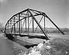 |
February 4, 1985 (#85000199) | July 22, 1994 | County Road 3400R at North Fork Gunnison River | Hotchkiss | Demolished Summer 1988[6] |
| 4 | Roubideau Bridge |  |
February 4, 1985 (#85000197) | July 22, 1994 | County Road G50R at Gunnison River | Delta | Demolished Summer 1992[6] |
See also edit
References edit
- ^ The latitude and longitude information provided in this table was derived originally from the National Register Information System, which has been found to be fairly accurate for about 99% of listings. Some locations in this table may have been corrected to current GPS standards.
- ^ National Park Service, United States Department of the Interior, "National Register of Historic Places: Weekly List Actions", retrieved April 12, 2024.
- ^ a b Numbers represent an alphabetical ordering by significant words. Various colorings, defined here, differentiate National Historic Landmarks and historic districts from other NRHP buildings, structures, sites or objects.
- ^ "National Register Information System". National Register of Historic Places. National Park Service. July 9, 2010.
- ^ The eight-digit number below each date is the number assigned to each location in the National Register Information System database, which can be viewed by clicking the number.
- ^ a b c d "Colorado Office of Archaeology and Historic Preservation | Properties removed from the National and State Registers". Archived from the original on 2012-08-18. Retrieved 2012-08-17.
External links edit
Wikimedia Commons has media related to Delta County, Colorado.
- State of Colorado
- History Colorado
- Delta County, Colorado
38°51′41″N 107°51′48″W / 38.8614°N 107.8632°W