
KNOWPIA
WELCOME TO KNOWPIA

National Register of Historic Places listings in Deuel County, South Dakota 
Summary
This is a list of the National Register of Historic Places listings in Deuel County, South Dakota.
This is intended to be a complete list of the properties and districts on the National Register of Historic Places in Deuel County, South Dakota, United States. The locations of National Register properties and districts for which the latitude and longitude coordinates are included below, may be seen in a map.[1]
There are 10 properties and districts listed on the National Register in the county.
This National Park Service list is complete through NPS recent listings posted April 5, 2024.[2]
Current listings edit
| [3] | Name on the Register[4] | Image | Date listed[5] | Location | City or town | Description |
|---|---|---|---|---|---|---|
| 1 | Deuel County Courthouse and Jail |  |
June 16, 1976 (#76001730) |
Highway 22 44°45′19″N 96°41′05″W / 44.755264°N 96.68478944°W | Clear Lake | Courthouse, built 1916, designed by Buechner & Orth. Attached jail built 1899. |
| 2 | East Highland Lutheran Church | February 18, 2000 (#00000120) |
Approximately 6 miles northeast of Brandt 44°40′29″N 96°31′31″W / 44.674722°N 96.525278°W | Brandt | ||
| 3 | First National Bank Building | December 2, 1977 (#77001242) |
Off Highway 22 44°47′34″N 96°27′24″W / 44.792778°N 96.456667°W | Gary | ||
| 4 | Herrick Barn | June 22, 2005 (#05000628) |
0.5 miles northwest of the junction of County Road 310 and Highway 101 44°47′43″N 96°28′01″W / 44.795278°N 96.466944°W | Gary | ||
| 5 | Hoffman Barn | October 26, 2005 (#05001188) |
16937 482 Ave. 44°55′47″N 96°33′31″W / 44.929722°N 96.558611°W | Revillo | ||
| 6 | Kliegle Garage | September 29, 1999 (#99001213) |
Lots 1 and 2 of the original townsite of Goodwin 44°52′41″N 96°51′02″W / 44.878056°N 96.850556°W | Goodwin | ||
| 7 | Odd Fellows Building | June 3, 1976 (#76001731) |
Main St. 44°47′34″N 96°27′24″W / 44.792778°N 96.456667°W | Gary | ||
| 8 | Old Cochrane Road Bridge | 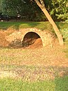 |
December 9, 1993 (#93001268) |
Abandoned local road over the inlet to Lake Cochrane 44°42′03″N 96°29′15″W / 44.700833°N 96.4875°W | Brandt | |
| 9 | South Dakota Dept. of Transportation Bridge No. 20-153-210 | December 9, 1993 (#93001286) |
Local road over Cobb Creek 44°40′27″N 96°34′28″W / 44.674167°N 96.574444°W | Brandt | ||
| 10 | South Dakota School for the Blind | May 26, 1988 (#88000570) |
Coteau and 3rd Sts. 44°47′46″N 96°27′18″W / 44.796111°N 96.455°W | Gary |
See also edit
Wikimedia Commons has media related to National Register of Historic Places in Deuel County, South Dakota.
References edit
- ^ The latitude and longitude information provided in this table was derived originally from the National Register Information System, which has been found to be fairly accurate for about 99% of listings. Some locations in this table may have been corrected to current GPS standards.
- ^ National Park Service, United States Department of the Interior, "National Register of Historic Places: Weekly List Actions", retrieved April 5, 2024.
- ^ Numbers represent an alphabetical ordering by significant words. Various colorings, defined here, differentiate National Historic Landmarks and historic districts from other NRHP buildings, structures, sites or objects.
- ^ "National Register Information System". National Register of Historic Places. National Park Service. April 24, 2008.
- ^ The eight-digit number below each date is the number assigned to each location in the National Register Information System database, which can be viewed by clicking the number.