
KNOWPIA
WELCOME TO KNOWPIA

National Register of Historic Places listings in Emery County, Utah 
Summary
This is a list of the National Register of Historic Places listings in Emery County, Utah.

This is intended to be a complete list of the properties and districts on the National Register of Historic Places in Emery County, Utah, United States. Latitude and longitude coordinates are provided for many National Register properties and districts; these locations may be seen together in a map.[1]
There are 22 properties and districts listed on the National Register in the county, including 1 National Historic Landmark.
This National Park Service list is complete through NPS recent listings posted April 5, 2024.[2]
Current listings edit
| [3] | Name on the Register[4] | Image | Date listed[5] | Location | City or town | Description |
|---|---|---|---|---|---|---|
| 1 | Black Dragon Canyon Pictographs | 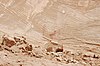 |
September 4, 1980 (#80003905) |
Address Restricted | Green River | |
| 2 | Buckhorn Wash Rock Art Sites |  |
August 1, 1980 (#80003898) |
Address Restricted | Castle Dale | |
| 3 | Castle Dale Bridge | 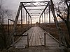 |
September 13, 2019 (#100004394) |
approximately 200 S. Center St., spanning Cottonwood Creek 39°12′32″N 111°01′14″W / 39.208857°N 111.020564°W | Castle Dale vicinity | |
| 4 | Castle Dale High School Shop | 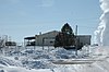 |
April 1, 1985 (#85000804) |
300 N. Center St. 39°12′59″N 111°01′13″W / 39.216389°N 111.020278°W | Castle Dale | |
| 5 | Castle Dale School |  |
September 6, 1978 (#78002657) |
65 E. 100 North 39°12′51″N 111°01′02″W / 39.214167°N 111.017222°W | Castle Dale | Now houses the Castle Dale City Hall and the Emery County Pioneer Museum |
| 6 | Paul C. Christensen House |  |
December 2, 1980 (#80003899) |
15 E. 100 North 39°12′48″N 111°01′10″W / 39.213439°N 111.019339°W | Castle Dale | Victorian house from 1906, home and office of Castle Dale's first dentist. |
| 7 | Denver and Rio Grande Lime Kiln |  |
August 26, 1980 (#80003901) |
Southeast of Cleveland, along County Rd. 335 south of Cedar Mountain 39°11′16″N 110°42′09″W / 39.187847°N 110.702569°W | Cleveland | |
| 8 | Desolation Canyon |  |
November 24, 1968 (#68000057) |
Along the Green River in northeastern Emery County between Ouray and Green River[6] 39°30′01″N 110°01′19″W / 39.500278°N 110.021944°W | Green River | Split between Emery, Grand, Carbon, and Uintah counties |
| 9 | Emery LDS Church | 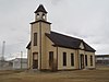 |
February 22, 1980 (#80003903) |
Off State Route 10 38°55′27″N 111°14′48″W / 38.924167°N 111.246667°W | Emery | |
| 10 | Ferron Box Pictographs and Petroglyphs |  |
July 11, 1980 (#80003904) |
Address Restricted | Ferron | |
| 11 | Ferron Presbyterian Church and Cottage |  |
September 6, 1978 (#78002658) |
Mill Rd. and 3rd West 39°05′36″N 111°08′28″W / 39.093333°N 111.141111°W | Ferron | |
| 12 | Green River Presbyterian Church |  |
January 5, 1989 (#88002998) |
134 W. 3rd Ave. 38°59′45″N 110°09′54″W / 38.995833°N 110.165°W | Green River | |
| 13 | Huntington Roller Mill and Miller's House |  |
September 27, 1979 (#79002495) |
400 North and 550 West Sts. 39°20′02″N 110°58′36″W / 39.333889°N 110.976667°W | Huntington | |
| 14 | Huntington Tithing Granary |  |
January 25, 1985 (#85000261) |
45 W. 300 North, rear 39°19′53″N 110°57′55″W / 39.331389°N 110.965278°W | Huntington | |
| 15 | Peter Johansen House | 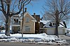 |
March 19, 1980 (#80003900) |
830 N. Center St. 39°13′35″N 111°01′07″W / 39.226389°N 111.018611°W | Castle Dale | |
| 16 | Lars Peter Larson House | 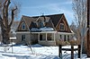 |
February 13, 1980 (#80003902) |
210 E. 100 South 39°20′49″N 110°50′49″W / 39.346944°N 110.846944°W | Cleveland | |
| 17 | Leander Lemmon House | 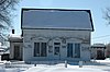 |
September 12, 2002 (#02001040) |
45 W. Center St. 39°19′34″N 110°57′54″W / 39.326111°N 110.965°W | Huntington | |
| 18 | Rochester-Muddy Creek Petroglyph Site |  |
June 26, 1975 (#75001803) |
Address Restricted | Emery | |
| 19 | San Rafael Bridge |  |
June 3, 1996 (#96000617) |
County Road 3-32 over the San Rafael River, approximately 23 miles (37 km) southeast of Castle Dale 39°04′52″N 110°39′49″W / 39.081111°N 110.663611°W | Castle Dale | |
| 20 | Justus Wellington Seeley II House |  |
November 15, 1979 (#79002493) |
Center and 100 South Sts. 39°12′40″N 111°01′06″W / 39.211111°N 111.018333°W | Castle Dale | |
| 21 | Samuel Singleton House |  |
November 8, 1979 (#79002494) |
South of Ferron on State Route 10 39°05′02″N 111°07′57″W / 39.083889°N 111.1325°W | Ferron | |
| 22 | Temple Mountain Wash Pictographs |  |
March 15, 1976 (#76001814) |
Address Restricted | Hanksville |
See also edit
References edit
- ^ The latitude and longitude information provided in this table was derived originally from the National Register Information System, which has been found to be fairly accurate for about 99% of listings. Some locations in this table may have been corrected to current GPS standards.
- ^ National Park Service, United States Department of the Interior, "National Register of Historic Places: Weekly List Actions", retrieved April 5, 2024.
- ^ Numbers represent an alphabetical ordering by significant words. Various colorings, defined here, differentiate National Historic Landmarks and historic districts from other NRHP buildings, structures, sites or objects.
- ^ "National Register Information System". National Register of Historic Places. National Park Service. April 24, 2008.
- ^ The eight-digit number below each date is the number assigned to each location in the National Register Information System database, which can be viewed by clicking the number.
- ^ Location and coordinates derived from its GNIS entry; the NRIS lists the site as "Address unknown"
External links edit
![]() Media related to National Register of Historic Places in Emery County, Utah at Wikimedia Commons
Media related to National Register of Historic Places in Emery County, Utah at Wikimedia Commons