
KNOWPIA
WELCOME TO KNOWPIA

National Register of Historic Places listings in Fairfield County, South Carolina 
Summary
This is a list of the National Register of Historic Places listings in Fairfield County, South Carolina.

This is intended to be a complete list of the properties and districts on the National Register of Historic Places in Fairfield County, South Carolina, United States. The locations of National Register properties and districts for which the latitude and longitude coordinates are included below, may be seen in a map.[1]
There are 43 properties and districts listed on the National Register in the county. Another 2 properties were once listed but have been removed.
This National Park Service list is complete through NPS recent listings posted April 5, 2024.[2]
Current listings edit
| [3] | Name on the Register[4] | Image | Date listed[5] | Location | City or town | Description |
|---|---|---|---|---|---|---|
| 1 | Albion |  |
December 6, 1984 (#84000592) |
West of Winnsboro off South Carolina Highway 34 34°27′22″N 81°14′36″W / 34.456111°N 81.243333°W | Winnsboro | |
| 2 | Balwearie |  |
December 6, 1984 (#84000593) |
West of Winnsboro on South Carolina Highway 34 34°27′14″N 81°14′41″W / 34.453889°N 81.244722°W | Winnsboro | |
| 3 | Blair Mound | August 23, 1974 (#74001853) |
Address Restricted | Winnsboro | ||
| 4 | Blink Bonnie |  |
April 13, 1972 (#72001209) |
About 10 miles northeast of Ridgeway 34°20′15″N 80°49′14″W / 34.3375°N 80.820556°W | Ridgeway | |
| 5 | Dr. Walter Brice House and Office |  |
December 6, 1984 (#84000594) |
Northwest of Winnsboro 34°30′17″N 81°14′40″W / 34.504722°N 81.244444°W | Winnsboro | |
| 6 | Camp Welfare |  |
December 6, 1984 (#84000586) |
Off U.S. Route 21 34°29′23″N 80°57′04″W / 34.489722°N 80.951111°W | Ridgeway | |
| 7 | Century House |  |
August 19, 1971 (#71000777) |
South Carolina Highway 34 34°18′13″N 80°57′30″W / 34.303611°N 80.958333°W | Ridgeway | |
| 8 | Concord Presbyterian Church |  |
December 6, 1984 (#84000598) |
U.S. Route 321 34°31′27″N 81°10′10″W / 34.524167°N 81.169444°W | Winnsboro | |
| 9 | Davis Plantation |  |
May 6, 1971 (#71000776) |
South of Monticello on South Carolina Highway 215 34°22′36″N 81°18′59″W / 34.376667°N 81.316389°W | Monticello | |
| 10 | Ebenezer Associate Reformed Presbyterian Church |  |
August 19, 1971 (#71000775) |
4.3 miles north of Jenkinsville on South Carolina Highway 213 34°19′09″N 81°15′39″W / 34.319167°N 81.260833°W | Jenkinsville | Also known as First ARP Church or "Old Brick Church." Built in 1788. |
| 11 | Fonti Flora Plantation |  |
April 24, 1979 (#79002382) |
5.4 miles northeast of Monticello on South Carolina Highway 99 34°24′06″N 81°20′45″W / 34.401667°N 81.345833°W | Monticello | |
| 12 | Furman Institution Faculty Residence |  |
December 6, 1984 (#84000601) |
Southwest of Winnsboro 34°20′53″N 81°07′23″W / 34.348056°N 81.123056°W | Winnsboro | |
| 13 | Dr. John Glenn House |  |
December 6, 1984 (#84000572) |
South Carolina Highway 215 34°14′51″N 81°15′06″W / 34.2475°N 81.251667°W | Jenkinsville | |
| 14 | High Point | 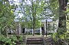 |
December 6, 1984 (#84000576) |
South Carolina Highway 215 34°14′47″N 81°14′56″W / 34.246389°N 81.248889°W | Jenkinsville | |
| 15 | Hunstanton |  |
December 6, 1984 (#84000604) |
U.S. Route 321 34°21′06″N 81°05′11″W / 34.351667°N 81.086389°W | Winnsboro | |
| 16 | Hunter House | December 6, 1984 (#84000588) |
Northeast of Ridgeway 34°19′27″N 80°56′05″W / 34.324167°N 80.934722°W | Ridgeway | ||
| 17 | Ketchin Building |  |
December 18, 1970 (#70000588) |
231 S. Congress St. 34°22′33″N 81°05′08″W / 34.375833°N 81.085556°W | Winnsboro | |
| 18 | Kincaid-Anderson House |  |
July 30, 1974 (#74001852) |
Northeast of Jenkinsville off South Carolina Highway 213 34°19′10″N 81°14′32″W / 34.319444°N 81.242222°W | Jenkinsville | |
| 19 | Bob Lemmon House | December 6, 1984 (#84000607) |
Off South Carolina Highway 213 34°19′44″N 81°10′33″W / 34.328889°N 81.175833°W | Winnsboro | ||
| 20 | Liberty Universalist Church and Feasterville Academy Historic District |  |
December 6, 1984 (#84000612) |
South Carolina Highway 215 34°30′13″N 81°21′36″W / 34.503611°N 81.36°W | Winnsboro | |
| 21 | Little River Baptist Church | 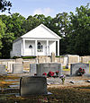 |
April 13, 1972 (#72001208) |
3.8 miles north of Jenkinsville on South Carolina Highway 213 34°18′38″N 81°16′31″W / 34.310556°N 81.275278°W | Jenkinsville | |
| 22 | Mayfair | February 6, 1985 (#85000246) |
Off South Carolina Highway 215 34°15′42″N 81°17′34″W / 34.261667°N 81.292778°W | Jenkinsville | ||
| 23 | McMeekin Rock Shelter | August 23, 1974 (#74001854) |
Address Restricted | Winnsboro | ||
| 24 | Monticello Methodist Church |  |
December 6, 1984 (#84000578) |
Off South Carolina Highway 215 34°20′59″N 81°17′57″W / 34.349722°N 81.299167°W | Monticello | |
| 25 | Monticello Store and Post Office |  |
December 6, 1984 (#84000584) |
Off South Carolina Highway 215 34°21′11″N 81°17′58″W / 34.353056°N 81.299444°W | Monticello | |
| 26 | Mount Hope | December 6, 1984 (#84000589) |
South Carolina Highway 34 34°17′58″N 80°59′18″W / 34.299444°N 80.988333°W | Ridgeway | ||
| 27 | Mount Olivet Presbyterian Church |  |
August 13, 1986 (#86001523) |
Off South Carolina Highway 200 34°27′55″N 81°02′02″W / 34.465278°N 81.033889°W | Winnsboro | |
| 28 | Mt. Zion Institute High School |  |
September 30, 2019 (#100004445) |
250 N. Walnut St. 34°23′02″N 81°05′02″W / 34.3838°N 81.0839°W | Winnsboro | |
| 29 | New Hope A.R.P. Church and Session House |  |
December 6, 1984 (#84000652) |
Northwest of Winnsboro 34°30′33″N 81°14′47″W / 34.509167°N 81.246389°W | Winnsboro | |
| 30 | Old Stone House |  |
December 6, 1984 (#84000614) |
Off South Carolina Highway 34 34°23′48″N 81°11′53″W / 34.396667°N 81.198056°W | Winnsboro | |
| 31 | Ridgeway Historic District |  |
November 25, 1980 (#80004466) |
U.S. Route 21 and South Carolina Highway 34 34°18′26″N 80°57′39″W / 34.307222°N 80.960833°W | Ridgeway | |
| 32 | Rockton and Rion Railroad Historic District |  |
December 6, 1984 (#84000617) |
South of Winnsboro from South Carolina Highway 34 west to South Carolina Highway 213 34°19′09″N 81°09′19″W / 34.319167°N 81.155278°W | Winnsboro | |
| 33 | Ruff's Chapel |  |
November 25, 1980 (#80004400) |
U.S. Route 21 and South Carolina Highway 34 34°18′15″N 80°57′28″W / 34.304167°N 80.957778°W | Ridgeway | |
| 34 | Rural Point |  |
February 23, 1972 (#72001210) |
Old Camden Rd. 34°21′57″N 81°04′36″W / 34.365833°N 81.076667°W | Winnsboro | |
| 35 | St. Stephen's Episcopal Church |  |
May 6, 1971 (#71000778) |
Northeast of Ridgeway on County Road 106 34°18′42″N 80°57′23″W / 34.311667°N 80.956389°W | Ridgeway | An 1854 Carpenter Gothic building which in 1920 had its wooden exterior veneered with brick. The Rev. William Porcher DuBose was an early rector. |
| 36 | Shivar Springs Bottling Company Cisterns |  |
December 6, 1984 (#84000622) |
West of Winnsboro 34°29′19″N 81°25′15″W / 34.488611°N 81.420833°W | Winnsboro | |
| 37 | The Oaks |  |
December 6, 1984 (#84000624) |
South Carolina Highway 213 34°21′15″N 81°10′44″W / 34.354167°N 81.178889°W | Winnsboro | |
| 38 | Tocaland |  |
December 6, 1984 (#84000627) |
Off South Carolina Highway 34 34°20′26″N 81°04′18″W / 34.340556°N 81.071667°W | Winnsboro | |
| 39 | Valencia |  |
May 6, 1971 (#71000779) |
Northwest of Ridgeway on County Road 106 34°19′40″N 80°59′00″W / 34.327778°N 80.983333°W | Ridgeway | |
| 40 | Vaughn's Stage Coach Stop |  |
December 6, 1984 (#84000591) |
South Carolina Highway 34 34°18′36″N 81°02′00″W / 34.31°N 81.033333°W | Ridgeway | |
| 41 | White Oak Historic District |  |
December 6, 1984 (#84000631) |
Off U.S. Route 321 34°28′26″N 81°07′02″W / 34.473889°N 81.117222°W | Winnsboro | |
| 42 | Monroe Wilson House |  |
November 25, 1980 (#80004467) |
Railroad Ave. and Secondary Route S20-20 34°18′30″N 80°57′54″W / 34.308333°N 80.965°W | Ridgeway | |
| 43 | Winnsboro Historic District |  |
October 14, 1971 (#71000780) |
Roughly bounded by Gooding, Buchanan, Garden, and Fairfield Sts. 34°22′50″N 81°05′11″W / 34.3804909°N 81.0864308°W | Winnsboro |
Former listings edit
| [3] | Name on the Register | Image | Date listed | Date removed | Location | City or town | Description |
|---|---|---|---|---|---|---|---|
| 1 | James Beard House | December 6, 1984 (#84000585) | December 8, 2005 | County Road 48, about 2 mi from County Road 294 | Ridgeway | Demolished | |
| 2 | Furman Institution Academic Building | December 6, 1984 (#84000600) | December 8, 2005 | South Carolina Highway 213 and County Roads 70 & 23 | Winnsboro | Demolished |
See also edit
Wikimedia Commons has media related to National Register of Historic Places in Fairfield County, South Carolina.
References edit
- ^ The latitude and longitude information provided in this table was derived originally from the National Register Information System, which has been found to be fairly accurate for about 99% of listings. Some locations in this table may have been corrected to current GPS standards.
- ^ National Park Service, United States Department of the Interior, "National Register of Historic Places: Weekly List Actions", retrieved April 5, 2024.
- ^ a b Numbers represent an alphabetical ordering by significant words. Various colorings, defined here, differentiate National Historic Landmarks and historic districts from other NRHP buildings, structures, sites or objects.
- ^ "National Register Information System". National Register of Historic Places. National Park Service. March 13, 2009.
- ^ The eight-digit number below each date is the number assigned to each location in the National Register Information System database, which can be viewed by clicking the number.