


Summary
This is a list of the National Register of Historic Places listings in Fannin County, Texas.

This is intended to be a complete list of properties and districts listed on the National Register of Historic Places in Fannin County, Texas. There are one National Historic Landmark, one district, six individual properties, and one former property listed on the National Register in the county. The National Historic Landmark is also a State Historic Site, a State Antiquities Landmark, and a Recorded Texas Historic Landmark while three additional individually listed properties are also Recorded Texas Historic Landmarks.
This National Park Service list is complete through NPS recent listings posted April 12, 2024.[1]
Current listings edit
The locations of National Register properties and districts may be seen in a mapping service provided.[2]
| [3] | Name on the Register | Image | Date listed[4] | Location | City or town | Description |
|---|---|---|---|---|---|---|
| 1 | Bonham VA Hospital | October 13, 2022 (#100008265) |
1201 East 9th St. 33°35′05″N 96°10′00″W / 33.584737°N 96.166560°W | Bonham | ||
| 2 | Clendenen-Carleton House |  |
May 14, 1979 (#79002937) |
803 N. Main St. 33°34′52″N 96°10′46″W / 33.581111°N 96.179444°W | Bonham | |
| 3 | Haden House |  |
January 8, 1980 (#80004118) |
603 W. Bonham St. 33°25′30″N 95°57′10″W / 33.425°N 95.952778°W | Ladonia | Recorded Texas Historic Landmark |
| 4 | Lake Fannin Organizational Camp | June 4, 2001 (#01000611) |
1 mi (1.6 km). W jct of Cty. Rd. 2025 and State Farm-to-Market Rd. 2554, Caddo National Grasslands 33°46′37″N 96°09′23″W / 33.776944°N 96.156389°W | Elwood | ||
| 5 | Sam Rayburn Library and Museum |  |
May 6, 2005 (#05000386) |
800 W. Sam Rayburn Dr. 33°34′42″N 96°11′16″W / 33.578333°N 96.187778°W | Bonham | Recorded Texas Historic Landmark |
| 6 | Samuel T. Rayburn House |  |
June 5, 1972 (#72001361) |
1.5 mi (2.4 km). W of Bonham on U.S. 82 33°34′10″N 96°12′22″W / 33.569444°N 96.206111°W | Bonham | State Historic Site, State Antiquities Landmark, Recorded Texas Historic Landmark |
| 7 | State Highway 78 Bridge at the Red River |  |
December 20, 1996 (#96001517) |
OK 78, across the Red River at the OK-TX state line 33°45′10″N 96°11′45″W / 33.752778°N 96.195833°W | Ravenna | Historic Bridges of Texas, 1866-1945 MPS; extends into Bryan County, Oklahoma |
| 8 | Texas and Pacific Railroad Depot | 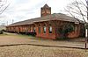 |
January 9, 1997 (#96001564) |
1 Main St. 33°34′25″N 96°10′45″W / 33.573611°N 96.179167°W | Bonham | Recorded Texas Historic Landmark |
| 9 | Thomas and Katherine Trout House | 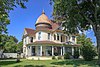 |
August 23, 1984 (#84001664) |
705 Poplar St. 33°35′11″N 95°54′16″W / 33.586389°N 95.904444°W | Honey Grove |
Former listing edit
| [3] | Name on the Register | Image | Date listed | Date removed | Location | City or town | Description |
|---|---|---|---|---|---|---|---|
| 1 | Nunn House | May 6, 1980 (#80004117) | June 8, 1998 | 505 W. 5th St. 33°34′41″N 96°11′02″W / 33.577938°N 96.183864°W | Bonham | Also known as the Nunn-Rainey House |
See also edit
References edit
- ^ National Park Service, United States Department of the Interior, "National Register of Historic Places: Weekly List Actions", retrieved April 12, 2024.
- ^ The latitude and longitude information provided in this table was derived originally from the National Register Information System, which has been found to be fairly accurate for about 99% of listings. Some locations in this table may have been corrected to current GPS standards.
- ^ a b Numbers represent an alphabetical ordering by significant words. Various colorings, defined here, differentiate National Historic Landmarks and historic districts from other NRHP buildings, structures, sites or objects.
- ^ The eight-digit number below each date is the number assigned to each location in the National Register Information System database, which can be viewed by clicking the number.
External links edit
![]() Media related to National Register of Historic Places in Fannin County, Texas at Wikimedia Commons
Media related to National Register of Historic Places in Fannin County, Texas at Wikimedia Commons