


Summary
This is a list of the National Register of Historic Places listings in Floyd County, Indiana.

This is intended to be a complete list of the properties and districts on the National Register of Historic Places in Floyd County, Indiana, United States. Latitude and longitude coordinates are provided for many National Register properties and districts; these locations may be seen together in an online map.[1]
There are 24 properties and districts listed on the National Register in the county. Another 3 properties were once listed but have been removed.
Properties and districts located in incorporated areas display the name of the municipality, while properties and districts in unincorporated areas display the name of their civil township. Properties and districts split between multiple jurisdictions display the names of all jurisdictions.
This National Park Service list is complete through NPS recent listings posted April 12, 2024.[2]
Current listings edit
| [3] | Name on the Register[4] | Image | Date listed[5] | Location | City or town | Description |
|---|---|---|---|---|---|---|
| 1 | Beard-Kerr Farm |  |
December 19, 2012 (#12001057) |
502 Georgetown-Lanesville Rd., southwest of Georgetown 38°16′47″N 85°58′42″W / 38.2797°N 85.9783°W | Georgetown Township | |
| 2 | Cedar Bough Place Historic District |  |
March 19, 2008 (#08000188) |
800 block of Cedar Bough Place 38°17′39″N 85°48′51″W / 38.2942°N 85.8142°W | New Albany | |
| 3 | Culbertson Mansion |  |
June 28, 1974 (#74000019) |
914 E. Main St. 38°17′11″N 85°48′46″W / 38.2864°N 85.8128°W | New Albany | |
| 4 | DePauw Avenue Historic District |  |
March 19, 2008 (#08000189) |
Roughly DePauw Ave. from Vincennes St. to Abersold Dr., the 1200 block of Beechwood Ave., and 1211 and 1214 Vance St. 38°18′06″N 85°48′39″W / 38.3017°N 85.8108°W | New Albany | |
| 5 | Division Street School |  |
July 15, 2002 (#02000193) |
1803 Conservative St. 38°17′35″N 85°48′18″W / 38.2931°N 85.805°W | New Albany | |
| 6 | East Spring Street Historic District | 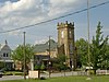 |
December 19, 2002 (#02001566) |
Roughly bounded by E. 5th, E. Spring, E. 8th, and E. Market Sts.; also roughly bounded by alley north/northwest of Elm St., the west curb line of Vincennes St., alley south/southwest of Market St., and the east curb line of 5th St. 38°17′18″N 85°48′57″W / 38.2883°N 85.8158°W | New Albany | Second set of addresses represent a boundary increase dated December 2, 2020. |
| 7 | Gabriel Farnsley House |  |
September 23, 1982 (#82000037) |
North of Bridgeport off State Road 111 38°11′19″N 85°54′27″W / 38.1886°N 85.9075°W | Franklin Township | |
| 8 | M. Fine and Sons Building |  |
September 11, 2018 (#100002917) |
1420 E. Main St. 38°17′18″N 85°48′29″W / 38.2883°N 85.8080°W | New Albany | |
| 9 | Charles and Elletha Frederick House | August 24, 2022 (#100008053) |
6954 US 150 38°21′03″N 85°56′14″W / 38.3509°N 85.9373°W | Floyds Knob vicinity | ||
| 10 | Georgetown Historic District | 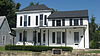 |
January 9, 2013 (#12001148) |
Roughly bounded by Georgetown-Greenville Rd., Canal Ln., Walnut St., and an unnamed alley 38°17′40″N 85°58′30″W / 38.2944°N 85.9750°W | Georgetown | |
| 11 | Louis and Anna K. Kunz Hartman House | August 23, 2022 (#100008059) |
911 State St. 38°17′32″N 85°49′39″W / 38.2921°N 85.8276°W | New Albany | ||
| 12 | Hedden's Grove Historic District |  |
December 27, 2010 (#10001076) |
1600 blocks of Hedden Park and Hedden Court, and 2410-2418 Charlestown Rd. 38°18′32″N 85°48′24″W / 38.3089°N 85.8067°W | New Albany | |
| 13 | Jersey Park Farm | 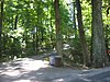 |
March 1, 1984 (#84001027) |
Off Cunningham Sarles and Borden Rds., northwest of Galena 38°22′39″N 85°57′39″W / 38.3775°N 85.9608°W | Greenville Township | |
| 14 | Mansion Row Historic District |  |
May 9, 1983 (#83000123) |
Main St. between State and 15th Sts., and Market St. between 7th and 11th Sts. 38°17′12″N 85°48′48″W / 38.2867°N 85.8133°W | New Albany | |
| 15 | New Albany Downtown Historic District |  |
September 3, 1999 (#99001074) |
Roughly between W. 1st St. and E. 5th St., and W. Main St. to E. Spring St. 38°17′07″N 85°49′18″W / 38.2853°N 85.8217°W | New Albany | |
| 16 | New Albany-Floyd County Public Library | August 23, 2022 (#100008054) |
180 West Spring St. 38°17′06″N 85°49′33″W / 38.2851°N 85.8259°W | New Albany | ||
| 17 | New Albany National Cemetery |  |
June 25, 1999 (#99000735) |
1943 Ekin Ave. 38°18′00″N 85°48′21″W / 38.3°N 85.8058°W | New Albany | |
| 18 | Old Pike Inn |  |
April 12, 2001 (#01000358) |
941 State St. 38°17′35″N 85°49′43″W / 38.2931°N 85.8286°W | New Albany | |
| 19 | Scribner House |  |
November 9, 1977 (#77000015) |
106 E. Main St. 38°17′00″N 85°49′21″W / 38.2833°N 85.8225°W | New Albany | |
| 20 | Shelby Place Historic District | 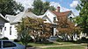 |
March 19, 2008 (#08000190) |
1500 and 1600 blocks of Shelby Place 38°17′48″N 85°48′42″W / 38.2967°N 85.8117°W | New Albany | |
| 21 | Simpson Memorial United Methodist Church |  |
September 29, 2004 (#04001098) |
9449 Harrison St. 38°22′23″N 85°59′29″W / 38.3731°N 85.9914°W | Greenville | |
| 22 | U.S. Court House and Federal Office Building | March 22, 2021 (#100006338) |
121 West Spring St. 38°17′07″N 85°49′29″W / 38.2853°N 85.8248°W | New Albany | ||
| 23 | Woodbine |  |
September 8, 1994 (#94001107) |
1800 Old Vincennes Rd. 38°17′35″N 85°51′09″W / 38.2931°N 85.8525°W | New Albany | |
| 24 | William Young House |  |
December 27, 2010 (#10001075) |
509 W. Market St. 38°16′55″N 85°49′46″W / 38.2819°N 85.8294°W | New Albany |
Former listings edit
| [3] | Name on the Register | Image | Date listed | Date removed | Location | City or town | Description |
|---|---|---|---|---|---|---|---|
| 1 | Yenowine-Nichols-Collins House |  |
May 12, 1975 (#75000017) | March 6, 2008 | 5118 State Road 64 | Georgetown | Burned down October 31, 2005 |
| 2 | New Albany and Salem Railroad Station | January 12, 1984 (#84001031) | March 25, 1996 | Pearl and Oak Sts. | New Albany | Demolished in December 1995. | |
| 3 | Sweet Gum Stable | March 14, 1996 (#96000292) | December 15, 2011 | 627 W. Main St. 38°16′49″N 85°49′47″W / 38.2803°N 85.8297°W | New Albany | Torn down May 22, 1999 |
See also edit
- List of National Historic Landmarks in Indiana
- National Register of Historic Places listings in Indiana
- Listings in neighboring counties: Clark, Harrison, Jefferson (KY), Washington
- List of Indiana state historical markers in Floyd County
- List of attractions and events in the Louisville metropolitan area
References edit
- ^ The latitude and longitude information provided in this table was derived originally from the National Register Information System, which has been found to be fairly accurate for about 99% of listings. Some locations in this table may have been corrected to current GPS standards.
- ^ National Park Service, United States Department of the Interior, "National Register of Historic Places: Weekly List Actions", retrieved April 12, 2024.
- ^ a b Numbers represent an alphabetical ordering by significant words. Various colorings, defined here, differentiate National Historic Landmarks and historic districts from other NRHP buildings, structures, sites or objects.
- ^ "National Register Information System". National Register of Historic Places. National Park Service. March 13, 2009.
- ^ The eight-digit number below each date is the number assigned to each location in the National Register Information System database, which can be viewed by clicking the number.