
KNOWPIA
WELCOME TO KNOWPIA

National Register of Historic Places listings in Franklin County, Nebraska 
Summary
This is a list of the National Register of Historic Places listings in Franklin County, Nebraska. It is intended to be a complete list of the properties and districts on the National Register of Historic Places in Franklin County, Nebraska, United States. The locations of National Register properties and districts for which the latitude and longitude coordinates are included below, may be seen in an online map.

There are 4 properties and districts listed on the National Register in the county, and three former listings.
This National Park Service list is complete through NPS recent listings posted April 5, 2024.[1]
Current listings edit
| [2] | Name on the Register[3] | Image | Date listed[4] | Location | City or town | Description |
|---|---|---|---|---|---|---|
| 1 | First Congregational Church, U.C.C. | 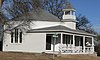 |
September 14, 1982 (#82003188) |
Off Nebraska Highway 31C 40°04′42″N 99°08′31″W / 40.078333°N 99.141944°W | Naponee | |
| 2 | Franklin County Courthouse | 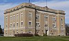 |
July 5, 1990 (#90000962) |
15th Ave. between N and O Sts. 40°05′51″N 98°57′14″W / 40.0975°N 98.953889°W | Franklin | |
| 3 | Lost Creek Archeological Site | May 26, 1983 (#83001094) |
Address Restricted | Bloomington | ||
| 4 | Republican River Bridge |  |
June 29, 1992 (#92000765) |
County road over the Republican River, 1 mile east and 1.5 miles south of Riverton 40°04′10″N 98°44′38″W / 40.069444°N 98.743889°W | Riverton |
Former listings edit
| [2] | Name on the Register | Image | Date listed | Date removed | Location | City or town | Description |
|---|---|---|---|---|---|---|---|
| 1 | Dupee Music Hall | 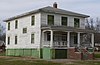 |
September 26, 1985 (#85002484) | March 17, 2017 | 1402 P St. 40°06′00″N 98°57′14″W / 40.1°N 98.953889°W | Franklin | |
| 2 | Franklin Bridge |  |
June 29, 1992 (#92000764) | March 13, 2020 | Nebraska Highway 10 over the Republican River, 1 mile south of Franklin 40°04′33″N 98°57′08″W / 40.075833°N 98.952222°W | Franklin | |
| 3 | Lincoln Hotel | 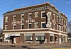 |
July 6, 1989 (#89000799) | March 22, 2016 | 519 15th Ave. 40°05′47″N 98°57′13″W / 40.096389°N 98.953611°W | Franklin |
See also edit
References edit
Wikimedia Commons has media related to National Register of Historic Places in Franklin County, Nebraska.
- ^ National Park Service, United States Department of the Interior, "National Register of Historic Places: Weekly List Actions", retrieved April 5, 2024.
- ^ a b Numbers represent an alphabetical ordering by significant words. Various colorings, defined here, differentiate National Historic Landmarks and historic districts from other NRHP buildings, structures, sites or objects.
- ^ "National Register Information System". National Register of Historic Places. National Park Service. March 13, 2009.
- ^ The eight-digit number below each date is the number assigned to each location in the National Register Information System database, which can be viewed by clicking the number.