
KNOWPIA
WELCOME TO KNOWPIA

National Register of Historic Places listings in Fulton County, Pennsylvania 
Summary
This is a list of the National Register of Historic Places listings in Fulton County, Pennsylvania.
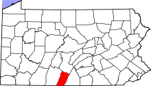
This is intended to be a complete list of the properties and districts on the National Register of Historic Places in Fulton County, Pennsylvania, United States. The locations of National Register properties and districts for which the latitude and longitude coordinates are included below, may be seen in a map.[1]
There are 8 properties and districts listed on the National Register in the county.
This National Park Service list is complete through NPS recent listings posted April 5, 2024.[2]
Current listings edit
| [3] | Name on the Register | Image | Date listed[4] | Location | City or town | Description |
|---|---|---|---|---|---|---|
| 1 | Burnt Cabins Gristmill Property | 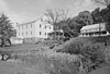 |
November 28, 1980 (#80003502) |
Allen's Valley Road 40°04′36″N 77°53′13″W / 40.076667°N 77.886944°W | Dublin Township | |
| 2 | Burnt Cabins Historic District |  |
May 20, 1998 (#98000566) |
Legislative Route 23905 and U.S. Route 522 40°04′44″N 77°53′43″W / 40.078889°N 77.895278°W | Dublin Township | |
| 3 | Cold Spring Farm |  |
August 10, 2000 (#00000966) |
323 Lions Park Drive near McConnellsburg 39°56′07″N 77°59′24″W / 39.935278°N 77.990000°W | Todd Township | |
| 4 | Cowans Gap State Park Family Cabin District | February 11, 1987 (#87000051) |
18 miles (29 km) north of Pennsylvania Route 75 and Chambersburg on Richmond Road 39°59′22″N 77°55′50″W / 39.989444°N 77.930556°W | Todd Township | ||
| 5 | Fulton House |  |
July 20, 1977 (#77001169) |
112–116 Lincoln Way East 39°55′56″N 77°59′55″W / 39.932222°N 77.998611°W | McConnellsburg | |
| 6 | McConnell House |  |
November 21, 1976 (#76001642) |
114 Lincoln Way 39°55′58″N 77°59′59″W / 39.932778°N 77.999722°W | McConnellsburg | |
| 7 | McConnellsburg Historic District |  |
August 9, 1993 (#93000727) |
Roughly along Lincoln Way from 1st Street to 5th Avenue and 2nd Street from Spruce Street to Maple Street 39°55′56″N 77°59′57″W / 39.932222°N 77.999167°W | McConnellsburg | |
| 8 | Woodvale Historic District |  |
July 24, 1992 (#92000942) |
Roughly bounded by Ash, High, North, Fulton, and Broad Streets in Woodvale 40°10′01″N 78°08′17″W / 40.166944°N 78.138056°W | Wells Township | Extends into Broad Top Township in Bedford County and Wood Township in Huntingdon County |
See also edit
Wikimedia Commons has media related to National Register of Historic Places in Fulton County, Pennsylvania.
References edit
- ^ The latitude and longitude information provided in this table was derived originally from the National Register Information System, which has been found to be fairly accurate for about 99% of listings. Some locations in this table may have been corrected to current GPS standards.
- ^ National Park Service, United States Department of the Interior, "National Register of Historic Places: Weekly List Actions", retrieved April 5, 2024.
- ^ Numbers represent an alphabetical ordering by significant words. Various colorings, defined here, differentiate National Historic Landmarks and historic districts from other NRHP buildings, structures, sites or objects.
- ^ The eight-digit number below each date is the number assigned to each location in the National Register Information System database, which can be viewed by clicking the number.