
KNOWPIA
WELCOME TO KNOWPIA

National Register of Historic Places listings in Gem County, Idaho 
Summary
This is a list of the National Register of Historic Places listings in Gem County, Idaho.

This is intended to be a complete list of the properties on the National Register of Historic Places in Gem County, Idaho, United States. Latitude and longitude coordinates are provided for many National Register properties and districts; these locations may be seen together in a map.[1]
There are 10 properties listed on the National Register in the county. More may be added; properties and districts nationwide are added to the Register weekly.[2]
This National Park Service list is complete through NPS recent listings posted April 12, 2024.[3]
Current listings edit
| [4] | Name on the Register[5] | Image | Date listed[6] | Location | City or town | Description |
|---|---|---|---|---|---|---|
| 1 | F. T. Bliss House | 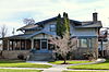 |
November 17, 1982 (#82000345) |
E. 2nd and McKinley Sts. 43°52′24″N 116°29′46″W / 43.873358°N 116.496159°W | Emmett | |
| 2 | Catholic Church of the Sacred Heart |  |
December 3, 1980 (#80001323) |
211 E. 1st St. 43°52′28″N 116°29′54″W / 43.874408°N 116.498411°W | Emmett | |
| 3 | Emmett Presbyterian Church |  |
December 3, 1980 (#80001324) |
223 E. 2nd St. 43°52′24″N 116°29′51″W / 43.873332°N 116.497492°W | Emmett | |
| 4 | First Baptist Church of Emmett |  |
December 3, 1980 (#80001325) |
126 S. Hayes Ave. 43°52′29″N 116°29′54″W / 43.874844°N 116.498414°W | Emmett | |
| 5 | Gem County Courthouse |  |
November 17, 1982 (#82000347) |
Main St. and McKinley Ave. 43°52′31″N 116°29′42″W / 43.875250°N 116.495106°W | Emmett | |
| 6 | Methodist Episcopal Church |  |
December 3, 1980 (#80001326) |
132 S. Washington Ave. 43°52′29″N 116°29′59″W / 43.874760°N 116.499741°W | Emmett | Building no longer exists. |
| 7 | Ola School |  |
May 5, 1992 (#92000415) |
5 Ola School Rd. 44°10′37″N 116°17′24″W / 44.176809°N 116.290119°W | Ola | |
| 8 | Oregon Short Line Railway Depot |  |
April 27, 1995 (#95000506) |
119 N. Commercial Ave. 43°52′35″N 116°30′05″W / 43.876389°N 116.501418°W | Emmett | |
| 9 | St. Mary's Episcopal Church |  |
December 3, 1980 (#80001327) |
219 E. 1st St. 43°52′28″N 116°29′51″W / 43.874398°N 116.497532°W | Emmett | |
| 10 | Sweet Methodist Episcopal Church |  |
July 9, 1997 (#97000766) |
7200 Sweet-Ola Highway 43°58′08″N 116°19′40″W / 43.969001°N 116.327685°W | Sweet |
Former listings edit
| [4] | Name on the Register | Image | Date listed | Date removed | Location | City or town | Description |
|---|---|---|---|---|---|---|---|
| 1 | Fletcher Oil Company Building | November 17, 1982 (#82000346) | October 16, 1989 | Main St. and Boise Ave. | Emmett | Destroyed by fire, October 4, 1989.[citation needed] |
See also edit
Wikimedia Commons has media related to National Register of Historic Places in Gem County, Idaho.
References edit
- ^ The latitude and longitude information provided in this table was derived originally from the National Register Information System, which has been found to be fairly accurate for about 99% of listings. Some locations in this table may have been corrected to current GPS standards.
- ^ "National Register of Historic Places: Weekly List Actions". National Park Service. Retrieved March 29, 2009.
- ^ National Park Service, United States Department of the Interior, "National Register of Historic Places: Weekly List Actions", retrieved April 12, 2024.
- ^ a b Numbers represent an alphabetical ordering by significant words. Various colorings, defined here, differentiate National Historic Landmarks and historic districts from other NRHP buildings, structures, sites or objects.
- ^ "National Register Information System". National Register of Historic Places. National Park Service. April 24, 2008.
- ^ The eight-digit number below each date is the number assigned to each location in the National Register Information System database, which can be viewed by clicking the number.