
KNOWPIA
WELCOME TO KNOWPIA

National Register of Historic Places listings in Gila County, Arizona 
Summary
This is a list of the National Register of Historic Places listings in Gila County, Arizona.

This is intended to be a complete list of the properties and districts on the National Register of Historic Places in Gila County, Arizona, United States. The locations of National Register properties and districts for which the latitude and longitude coordinates are included below may be seen in a map.[1]
There are 53 properties and districts listed on the National Register in the county, including 1 that is also a National Historic Landmark.
This National Park Service list is complete through NPS recent listings posted April 12, 2024.[2]
Current listings edit
| [3] | Name on the Register | Image | Date listed[4] | Location | City or town | Description |
|---|---|---|---|---|---|---|
| 1 | Archeological Site No. AR-03-12-06-1130(TNF) | April 21, 1989 (#89000273) |
Address Restricted | Punkin Center | ||
| 2 | Archeological Site No. AR-03-12-06-1131(TNF) | April 21, 1989 (#89000274) |
Address Restricted | Punkin Center | ||
| 3 | Besh-Ba-Gowah | 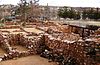 |
May 9, 1984 (#84000648) |
South of Globe 33°22′55″N 110°46′19″W / 33.3819°N 110.7719°W | Globe | |
| 4 | Black River Bridge | September 30, 1988 (#88001619) |
Indian Route 9 the over Black River 33°42′46″N 110°12′40″W / 33.7128°N 110.2111°W | Carrizo | ||
| 5 | Bullion Plaza School |  |
January 4, 2001 (#00001591) |
150 N. Plaza Circle Drive[5] 33°23′39″N 110°52′46″W / 33.39403°N 110.87951°W | Miami | Trost & Trost-designed school built in 1923 to facilitate segregation of Mexican American children. Now the Bullion Plaza Museum.[6] |
| 6 | Cline Terrace Platform Mound (AR-03-12-06-132 TNF) | April 21, 1989 (#89000269) |
Address Restricted | Punkin Center | ||
| 7 | Coolidge Dam |  |
October 29, 1981 (#81000135) |
Southwest of San Carlos 33°10′26″N 110°31′37″W / 33.1739°N 110.5269°W | San Carlos | |
| 8 | Cordova Avenue Bridge |  |
March 31, 1989 (#88001690) |
Cordova Ave. over Bloody Tanks Wash 33°23′52″N 110°52′20″W / 33.3979°N 110.8723°W | Miami | |
| 9 | Diamond Point Lookout Cabin | January 28, 1988 (#87002493) |
Tonto National Forest 34°17′15″N 111°11′32″W / 34.2875°N 111.1922°W | Tonto Village | ||
| 10 | Dominion Hotel |  |
May 22, 1978 (#78000545) |
S. Broad St. 33°23′42″N 110°47′11″W / 33.395°N 110.7864°W | Globe | Demolished after fire in 1980s.[7] |
| 11 | Elks Building |  |
August 6, 1987 (#87000860) |
155 W. Mesquite 33°23′51″N 110°47′19″W / 33.3975°N 110.7887°W | Globe | |
| 12 | Fossil Creek Bridge |  |
September 30, 1988 (#88001620) |
Forest Service Rd. over Fossil Creek 34°23′39″N 111°37′45″W / 34.3942°N 111.6292°W | Strawberry | |
| 13 | Gila County Courthouse |  |
May 27, 1975 (#75000347) |
Oak and Broad Sts. 33°23′46″N 110°47′11″W / 33.3961°N 110.7864°W | Globe | |
| 14 | Gila Pueblo |  |
November 17, 1977 (#77000235) |
South of Globe 33°21′53″N 110°46′01″W / 33.3647°N 110.7669°W | Globe | |
| 15 | Gila Valley Bank and Trust Building | 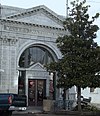 |
August 6, 1987 (#87000861) |
292 N. Broad St. 33°23′47″N 110°46′34″W / 33.3964°N 110.7761°W | Globe | |
| 16 | Globe Downtown Historic District |  |
May 28, 1987 (#87000862) |
Broad St. between Cedar and Tebbs 33°23′41″N 110°47′07″W / 33.3947°N 110.7853°W | Globe | |
| 17 | Globe Mine Rescue Station |  |
June 7, 1990 (#90000875) |
1330 N. Broad St. 33°24′35″N 110°47′43″W / 33.4096°N 110.7953°W | Globe | Now the Gila County Historical Museum.[8] |
| 18 | Holy Angels Church |  |
December 1, 1983 (#83003448) |
231 S. Broad St. 33°23′41″N 110°47′08″W / 33.3947°N 110.7856°W | Globe | |
| 19 | Houston Mesa Ruins |  |
September 4, 1986 (#86002191) |
Address Restricted | Payson | |
| 20 | Hunt Farmstead Historic District | March 29, 2021 (#100006316) |
4223 North Pine Creek Rd. 34°23′35″N 111°27′19″W / 34.3930°N 111.4552°W | Pine | ||
| 21 | Inspiration Avenue Bridge |  |
March 31, 1989 (#88001691) |
Inspiration Ave. over Bloody Tanks Wash 33°23′55″N 110°52′17″W / 33.3985°N 110.8713°W | Miami | |
| 22 | International House | 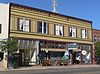 |
March 31, 1988 (#88000233) |
634-638 N. Broad St.[9] 33°24′01″N 110°47′24″W / 33.400143°N 110.789932°W | Globe | |
| 23 | Keystone Avenue Bridge |  |
March 31, 1989 (#88001692) |
Keystone Ave. over Bloody Tanks Wash 33°23′57″N 110°52′13″W / 33.399144°N 110.870408°W | Miami | |
| 24 | Kinishba Ruins | 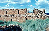 |
October 15, 1966 (#66000180) |
Address Restricted | Whiteriver | Pueblo ruins, designated a National Historic Landmark |
| 25 | Miami Avenue Bridge |  |
March 31, 1989 (#88001693) |
Miami Ave. over Bloody Tanks Wash 33°23′59″N 110°52′10″W / 33.399717°N 110.869445°W | Miami | |
| 26 | Miami Community Church |  |
March 15, 2005 (#05000137) |
305 W. Live Oak St.[10] 33°23′59″N 110°52′06″W / 33.399641°N 110.868209°W | Miami | |
| 27 | Pryor Miller House |  |
March 10, 2004 (#04000146) |
3800 State Route 87 34°23′08″N 111°27′16″W / 34.385556°N 111.454444°W | Pine | |
| 28 | Natural Bridge Lodge |  |
August 21, 1986 (#86001558) |
Off State Route 87 34°19′20″N 111°27′11″W / 34.322222°N 111.453056°W | Payson | |
| 29 | Oak Creek Platform Mound (AR-03-12-06-714 TNF) | April 21, 1989 (#89000271) |
Address Restricted | Punkin Center | ||
| 30 | Our Lady of the Blessed Sacrament Church |  |
January 2, 2008 (#07001332) |
844 W. Sullivan St.[11] 33°23′50″N 110°52′29″W / 33.397227°N 110.87477°W | Miami | |
| 31 | Ox Bow Inn | 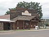 |
October 1, 2004 (#04001073) |
607 W. Main St. 34°13′51″N 111°20′10″W / 34.230833°N 111.336111°W | Payson | Rustic inn with design elements copied from Yellowstone's Old Faithful Inn |
| 32 | Park Creek Platform Mound (AR-03-12-06-1044 TNF) | April 21, 1989 (#89000272) |
Address Restricted | Punkin Center | ||
| 33 | Perkins Store | February 5, 1999 (#99000108) |
State Route 288, 1.5 miles southwest of Young 34°05′46″N 110°57′38″W / 34.096111°N 110.960556°W | Young | ||
| 34 | Pinal Ranger Station |  |
June 10, 1993 (#93000526) |
South of Globe in the Tonto National Forest 33°22′40″N 110°46′13″W / 33.377778°N 110.770278°W | Globe | |
| 35 | Pine Community Center Historic District | 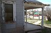 |
February 24, 2005 (#05000068) |
Bounded by Randall Dr., State Routes 87/260, unnamed service road, and Pine Creek Dr. 34°23′16″N 111°27′16″W / 34.387778°N 111.454444°W | Pine | |
| 36 | Pleasant Valley Ranger Station |  |
June 10, 1993 (#93000527) |
South of State Route 288 in the Tonto National Forest 34°06′53″N 110°56′27″W / 34.114722°N 110.940833°W | Young | |
| 37 | Alfred Jason Randall House |  |
September 29, 2000 (#00001165) |
State Route 87 34°23′11″N 111°27′15″W / 34.386389°N 111.454167°W | Pine | |
| 38 | Reppy Avenue Bridge |  |
September 30, 1988 (#88001689) |
Reppy Ave. over Bloody Tanks Wash 33°23′45″N 110°52′33″W / 33.395702°N 110.875944°W | Miami | |
| 39 | Rye Creek Ruin Platform Mound Complex Archeological District | November 24, 1995 (#95001311) |
Address Restricted | Rye | ||
| 40 | St. John's Episcopal Church |  |
November 22, 1977 (#77000234) |
185 E. Oak St.[12] 33°23′47″N 110°47′11″W / 33.396416°N 110.786428°W | Globe | |
| 41 | Salt River Bridge | September 30, 1988 (#88001604) |
State Route 288 over the Salt River at milepost 262.4 33°37′09″N 110°55′15″W / 33.619167°N 110.920833°W | Roosevelt | ||
| 42 | Salt River Canyon Bridge |  |
September 30, 1988 (#88001608) |
U.S. Route 60 over the Salt River at milepost 292.9 33°47′19″N 110°30′50″W / 33.788611°N 110.513889°W | Carrizo | |
| 43 | La Santa Cruz de Globe |  |
April 22, 2011 (#11000205) |
Hilltop in Ruiz Canyon, east of Navarro Dr. and west of Side Canyon 33°23′20″N 110°47′00″W / 33.388928°N 110.783285°W | Globe | |
| 44 | Schoolhouse Point (AR-03-12-06-13 TNF) | April 21, 1989 (#89000267) |
Address Restricted | Roosevelt | ||
| 45 | Soderman Building |  |
May 11, 2000 (#00000465) |
198 N. Chisholm Ave.[13] 33°23′56″N 110°52′21″W / 33.398974°N 110.872498°W | Miami | |
| 46 | Strawberry School |  |
May 10, 2005 (#05000422) |
9318 Fossil Creek Rd., approximately 1.5 miles west of State Routes 87/260 34°24′23″N 111°31′08″W / 34.406389°N 111.518889°W | Strawberry | |
| 47 | Theodore Roosevelt Dam National Register District |  |
March 16, 1998 (#98000144) |
Linear area along the shore of Lake Roosevelt from the dam to the canal intake 33°39′19″N 111°04′54″W / 33.655278°N 111.081667°W | Roosevelt | District includes resources that were involved in the construction of the dam, but the dam itself is not a contributing property[14] |
| 48 | Thompson Draw Summer Homes Unit 1 Historic District | July 23, 2014 (#14000420) |
221-584 Coyote Tr., 151-298 Ring Tail Wy., 14-194 Blue Jay Cir., 150-297 Kit Fox Pass 34°18′10″N 111°06′11″W / 34.302705°N 111.103164°W | Payson | ||
| 49 | Tonto National Monument Archeological District |  |
October 15, 1966 (#66000081) |
Address Restricted | Roosevelt | |
| 50 | Tonto National Monument Visitor Center |  |
September 9, 2010 (#10000734) |
Arizona State Highway 188 33°38′42″N 111°06′47″W / 33.645106°N 111.112985°W | Gila | |
| 51 | Tonto National Monument, Lower Ruin (AZ U:8:047A ASM) |  |
April 21, 1989 (#89000265) |
Off State Route 188 33°38′40″N 111°06′56″W / 33.644444°N 111.115556°W | Roosevelt | |
| 52 | Tonto National Monument, Upper Ruin (AZ U:8:048 ASM) |  |
April 21, 1989 (#89000266) |
Off State Route 188 33°38′27″N 111°06′56″W / 33.640833°N 111.115556°W | Roosevelt | |
| 53 | US Post Office and Courthouse-Globe Main |  |
December 3, 1985 (#85003106) |
101 S. Hill Street[15] 33°23′45″N 110°47′08″W / 33.395809°N 110.785629°W | Globe |
Former listings edit
| [3] | Name on the Register | Image | Date listed | Date removed | Location | City or town | Description |
|---|---|---|---|---|---|---|---|
| 1 | Zane Grey Lodge | May 31, 1974 (#74000453) | October 2, 1992 | N of Kohl's Ranch | Kohl's Ranch | Destroyed in the Dude fire, 1990.[16] | |
| 2 | Haught Cabin | August 4, 1987 (#87001515) | November 6, 1992 | 4 mi. N of Kohl's Ranch 34°13′56″N 111°20′40″W / 34.2323282°N 111.344319°W | Payson | Removed due to relocation to Green Valley Park in Payson.[17] | |
| 3 | Old Dominion Library |  |
May 22, 1978 (#78000546) | September 11, 1981 | Murphy St. | Globe | Destroyed by fire March 12, 1981.[18] |
See also edit
Wikimedia Commons has media related to National Register of Historic Places in Gila County, Arizona.
References edit
- ^ The latitude and longitude information provided in this table was derived originally from the National Register Information System, which has been found to be fairly accurate for about 99% of listings. Some locations in this table may have been corrected to current GPS standards.
- ^ National Park Service, United States Department of the Interior, "National Register of Historic Places: Weekly List Actions", retrieved April 12, 2024.
- ^ a b Numbers represent an alphabetical ordering by significant words. Various colorings, defined here, differentiate National Historic Landmarks and historic districts from other NRHP buildings, structures, sites or objects.
- ^ The eight-digit number below each date is the number assigned to each location in the National Register Information System database, which can be viewed by clicking the number.
- ^ "Bullion Plaza Museum". Archived 2013-09-17 at archive.today Globe-Miami Times. Retrieved 2013-09-17. Note that this webpage gives an address of "131 N. Plaza Circle" near the top; but further down, states "NOTE: Our Physical Address is really: 150 N Plaza Circle Drive".
- ^ "Bullion Plaza Museum". Archived 2013-09-17 at archive.today Globe-Miami Times. Retrieved 2013-09-17.
- ^ "Arizona Edison". Globe Main Street Program. Retrieved 2013-09-17.
- ^ "Museums/Art/Architecture - What You Can See Here..." Southern Gila County. Retrieved 2013-09-17.
- ^ The addresses "636" and "638" can be seen above the doors of the center and north bays in this photo. The number "634" above the door of the south bay is shown in this photo.
- ^ "Divine Grace (Miami)". Presbytery de Christo. Retrieved 2013-09-17.
- ^ "Our Lady of the Blessed Sacrament Church". Retrieved 2013-09-17.
- ^ "Directions". St. John's Episcopal Church. Retrieved 2013-09-17.
- ^ "About Us". Copper Miners' Rest. Retrieved 2013-09-17.
- ^ "Withdrawal of National Historic Landmark Designation: Roosevelt Dam, Gila and Maricopa Counties, Arizona". Retrieved 2010-03-05.
- ^ Address obtained by searching usps.com Archived 2014-12-23 at the Wayback Machine, "Find USPS Locations", for "Globe, AZ".
- ^ "It's no Grand Canyon, but Tonto Rim has its own grandeur". The News and Observer. June 27, 1993. p. 3H. Retrieved April 18, 2022 – via Newspapers.com.
- ^ "Cabin's rescue preserves bit of history in Payson". Arizona Republic. May 27, 2001. p. T1-T2. Retrieved April 18, 2022 – via Newspapers.com.
- ^ "Blaze guts old library in Globe". Arizona Republic. March 14, 1981. p. 9. Retrieved April 18, 2022 – via Newspapers.com.