


Summary
This is a list of the National Register of Historic Places listings in Greene County, Indiana.

This is intended to be a complete list of the properties and districts on the National Register of Historic Places in Greene County, Indiana, United States. Latitude and longitude coordinates are provided for many National Register properties and districts; these locations may be seen together in a map.[1]
There are 8 properties and districts listed on the National Register in the county.
Properties and districts located in incorporated areas display the name of the municipality, while properties and districts in unincorporated areas display the name of their civil township. Properties and districts split between multiple jurisdictions display the names of all jurisdictions.
This National Park Service list is complete through NPS recent listings posted April 12, 2024.[2]
Current listings edit
| [3] | Name on the Register[4] | Image | Date listed[5] | Location | City or town | Description |
|---|---|---|---|---|---|---|
| 1 | Greene County Courthouse | 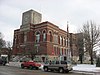 |
September 17, 2008 (#08000912) |
Main and Washington Sts. 39°01′35″N 86°56′16″W / 39.0265°N 86.9379°W | Bloomfield | |
| 2 | Linton Commercial Historic District |  |
March 30, 2007 (#07000214) |
Roughly bounded by B St., N., 1st St., E., A St., S., and 1st St., W. 39°02′03″N 87°09′58″W / 39.0342°N 87.1661°W | Linton | |
| 3 | Linton Public Library |  |
September 22, 2000 (#00001141) |
110 E. Vincennes St. 39°02′04″N 87°09′53″W / 39.0344°N 87.1647°W | Linton | |
| 4 | Old Clifty Church | August 31, 2020 (#100005506) |
3088 South Old Clifty Rd. 38°58′36″N 86°45′39″W / 38.9767°N 86.7608°W | Bloomfield | ||
| 5 | Osborn Site | 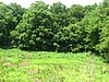 |
May 12, 1975 (#75000019) |
Southeastern quarter of the southwestern quarter of Section 28 Town 7 North Range 5 West, southwest of Bloomfield[6] 39°00′36″N 86°58′19″W / 39.0100°N 86.9719°W | Fairplay Township | |
| 6 | Richland-Plummer Creek Covered Bridge |  |
June 10, 1993 (#93000466) |
Baseline Rd. over Plummer Creek, south of Bloomfield 38°59′34″N 86°56′16″W / 38.9928°N 86.9378°W | Taylor Township | |
| 7 | Scotland Hotel |  |
May 27, 1993 (#93000467) |
Northeastern corner of the junction of Main and Jackson Sts. at Scotland 38°54′47″N 86°54′14″W / 38.9131°N 86.9039°W | Taylor Township | |
| 8 | Shakamak State Park Historic District |  |
March 15, 2000 (#00000199) |
6265 W. State Road 48, west of Jasonville 39°10′34″N 87°14′04″W / 39.1762°N 87.2345°W | Wright Township | Extends into Clay and Sullivan counties |
See also edit
References edit
- ^ The latitude and longitude information provided in this table was derived originally from the National Register Information System, which has been found to be fairly accurate for about 99% of listings. Some locations in this table may have been corrected to current GPS standards.
- ^ National Park Service, United States Department of the Interior, "National Register of Historic Places: Weekly List Actions", retrieved April 12, 2024.
- ^ Numbers represent an alphabetical ordering by significant words. Various colorings, defined here, differentiate National Historic Landmarks and historic districts from other NRHP buildings, structures, sites or objects.
- ^ "National Register Information System". National Register of Historic Places. National Park Service. March 13, 2009.
- ^ The eight-digit number below each date is the number assigned to each location in the National Register Information System database, which can be viewed by clicking the number.
- ^ Location derived from Black, Glenn A. "The Archaeology of Greene County." Indiana History Bulletin 10.5 (1933): 236-237. The NRIS lists the site as "Address Restricted".