
KNOWPIA
WELCOME TO KNOWPIA

National Register of Historic Places listings in Greene County, Virginia 
Summary
This is a list of the National Register of Historic Places listings in Greene County, Virginia.

This is intended to be a complete list of the properties and districts on the National Register of Historic Places in Greene County, Virginia, United States. The locations of National Register properties and districts for which the latitude and longitude coordinates are included below, may be seen in an online map.[1]
There are 9 properties and districts listed on the National Register in the county, including 1 National Historic Landmark.
This National Park Service list is complete through NPS recent listings posted April 5, 2024.[2]
Current listings edit
| [3] | Name on the Register[4] | Image | Date listed[5] | Location | City or town | Description |
|---|---|---|---|---|---|---|
| 1 | Beadles House |  |
November 22, 2000 (#00001433) |
515 Greene Acres Rd. 38°19′24″N 78°27′19″W / 38.3232°N 78.4554°W | Stanardsville | |
| 2 | Gibson Memorial Chapel and Martha Bagby Battle House at Blue Ridge School |  |
April 29, 1993 (#93000349) |
Western side of Bacon Hollow Rd., northwest of its junction with Dyke Rd. 38°16′01″N 78°33′24″W / 38.2669°N 78.5567°W | Dyke | |
| 3 | Greene County Courthouse | 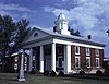 |
February 26, 1970 (#70000799) |
South of the junction of U.S. Route 33 and Blakey Ave. 38°17′47″N 78°26′23″W / 38.2964°N 78.4397°W | Stanardsville | |
| 4 | Locust Grove |  |
September 25, 1987 (#87001733) |
Davis Rd. 38°14′34″N 78°27′43″W / 38.2428°N 78.4619°W | Amicus | |
| 5 | A.J. Long Mill | September 15, 2020 (#100005576) |
4147 Simmons Gap Rd. 38°16′00″N 78°36′23″W / 38.2668°N 78.6063°W | Free Union vicinity | ||
| 6 | Octonia Stone |  |
September 15, 1970 (#70000800) |
North of Stanardsville, off Octonia Rd. 38°19′59″N 78°27′14″W / 38.3331°N 78.4539°W | Stanardsville | |
| 7 | Powell–McMullan House |  |
November 21, 2002 (#02001367) |
233 McMullen Mill Rd. 38°20′59″N 78°27′31″W / 38.3496°N 78.4586°W | Stanardsville | |
| 8 | Skyline Drive Historic District |  |
April 28, 1997 (#97000375) |
Shenandoah National Park, from the north entrance station at Front Royal to the south entrance station at the Rockfish Gap 38°23′14″N 78°30′32″W / 38.3872°N 78.5089°W | Luray | |
| 9 | Stanardsville Historic District |  |
May 27, 2004 (#04000555) |
Roughly along Main St., from Monroe Ave. to Lambs Ln., including parts of Madison Rd. 38°17′50″N 78°26′24″W / 38.2972°N 78.4400°W | Stanardsville |
See also edit
Wikimedia Commons has media related to National Register of Historic Places in Greene County, Virginia.
References edit
- ^ The latitude and longitude information provided in this table was derived originally from the National Register Information System, which has been found to be fairly accurate for about 99% of listings. Some locations in this table may have been corrected to current GPS standards.
- ^ National Park Service, United States Department of the Interior, "National Register of Historic Places: Weekly List Actions", retrieved April 5, 2024.
- ^ Numbers represent an alphabetical ordering by significant words. Various colorings, defined here, differentiate National Historic Landmarks and historic districts from other NRHP buildings, structures, sites or objects.
- ^ "National Register Information System". National Register of Historic Places. National Park Service. April 24, 2008.
- ^ The eight-digit number below each date is the number assigned to each location in the National Register Information System database, which can be viewed by clicking the number.