
KNOWPIA
WELCOME TO KNOWPIA

National Register of Historic Places listings in Hardin County, Ohio 
Summary
This is a list of the National Register of Historic Places listings in Hardin County, Ohio.

It is intended to be a complete list of the properties and districts on the National Register of Historic Places in Hardin County, Ohio, United States. The locations of National Register properties and districts for which the latitude and longitude coordinates are included below, may be seen in a Google map.[1]
There are 7 properties and districts listed on the National Register in the county.
This National Park Service list is complete through NPS recent listings posted April 12, 2024.[2]
Current listings edit
| [3] | Name on the Register[4] | Image | Date listed[5] | Location | City or town | Description |
|---|---|---|---|---|---|---|
| 1 | Ada Pennsylvania Station and Railroad Park | 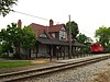 |
August 7, 1998 (#98001014) |
112 E. Central Ave. 40°46′14″N 83°49′20″W / 40.770556°N 83.822222°W | Ada | Former Pennsylvania Railroad station |
| 2 | Hardin County Courthouse |  |
March 21, 1979 (#79001863) |
Courthouse Sq. 40°38′52″N 83°36′31″W / 40.647667°N 83.608611°W | Kenton | Neoclassical 1913 courthouse |
| 3 | Kenton Courthouse Square Historic District |  |
August 23, 1984 (#84003722) |
Roughly Main, Detroit, Market, Columbus, and Franklin Sts. 40°38′52″N 83°36′31″W / 40.647667°N 83.608611°W | Kenton | |
| 4 | Kenton Public Library | 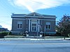 |
December 29, 1983 (#83004311) |
121 N. Detroit St. 40°38′54″N 83°36′35″W / 40.648333°N 83.609722°W | Kenton | A Carnegie library |
| 5 | Mount Victory Historic District |  |
April 19, 2001 (#01000390) |
Main and Taylor Sts. 40°32′04″N 83°31′15″W / 40.53433°N 83.52096°W | Mount Victory | |
| 6 | North Main-North Detroit Street Historic District |  |
April 18, 1985 (#85000867) |
Roughly Main St. bounded by Marie, Cherry, Carroll, and Detroit Sts. 40°39′06″N 83°36′28″W / 40.65168°N 83.60776°W | Kenton | An upscale residential neighborhood with several significant churches |
| 7 | Zimmerman Kame |  |
July 30, 1974 (#74001523) |
Off Township Road 39 northeast of Roundhead[6] 40°34′25″N 83°49′10″W / 40.573500°N 83.819333°W | McDonald Township | Archaeological site associated with the Glacial Kame culture |
See also edit
Wikimedia Commons has media related to National Register of Historic Places in Hardin County, Ohio.
- List of National Historic Landmarks in Ohio
- Listings in neighboring counties: Allen, Auglaize, Hancock, Logan, Marion, Union, Wyandot
- National Register of Historic Places listings in Ohio
References edit
- ^ The latitude and longitude information provided in this table was derived originally from the National Register Information System, which has been found to be fairly accurate for about 99% of listings. Some locations in this table may have been corrected to current GPS standards.
- ^ National Park Service, United States Department of the Interior, "National Register of Historic Places: Weekly List Actions", retrieved April 12, 2024.
- ^ Numbers represent an alphabetical ordering by significant words. Various colorings, defined here, differentiate National Historic Landmarks and historic districts from other NRHP buildings, structures, sites or objects.
- ^ "National Register Information System". National Register of Historic Places. National Park Service. April 24, 2008.
- ^ The eight-digit number below each date is the number assigned to each location in the National Register Information System database, which can be viewed by clicking the number.
- ^ Drennen, Bert C., III. National Register of Historic Places Inventory/Nomination: Zimmerman Kame. National Park Service, 1974-01-22.