
KNOWPIA
WELCOME TO KNOWPIA

National Register of Historic Places listings in Jasper County, South Carolina 
Summary
This is a list of the National Register of Historic Places listings in Jasper County, South Carolina.

This is intended to be a complete list of the properties on the National Register of Historic Places in Jasper County, South Carolina, United States. The locations of National Register properties, for which the latitude and longitude coordinates are included below, may be seen in a map.[1]
There are 10 properties listed on the National Register in the county. An additional property was once listed, but has since been removed.
This National Park Service list is complete through NPS recent listings posted April 5, 2024.[2]
Current listings edit
| [3] | Name on the Register[4] | Image | Date listed[5] | Location | City or town | Description |
|---|---|---|---|---|---|---|
| 1 | Church of the Holy Trinity |  |
March 25, 1982 (#82003869) |
South Carolina Secondary Highways S-27-13 and S-27-29 32°28′12″N 80°57′55″W / 32.47°N 80.965278°W | Ridgeland | |
| 2 | Gillisonville Baptist Church | 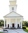 |
May 14, 1971 (#71000786) |
U.S. Route 278 32°36′26″N 80°59′52″W / 32.607222°N 80.997778°W | Gillisonville | |
| 3 | Honey Hill-Boyd's Neck Battlefield |  |
July 3, 2004 (#04000655) |
Atop and east of Honey Hill, east of Ridgeland[6] 32°28′56″N 80°56′04″W / 32.4822°N 80.9344°W | Ridgeland | |
| 4 | Old House Plantation | 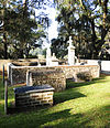 |
October 6, 1997 (#97001159) |
Off South Carolina Highway 462, just south of Old House[7] 32°27′28″N 80°53′52″W / 32.4578°N 80.8978°W | Ridgeland | Includes the grave of Thomas Heyward, Jr.[8] |
| 5 | Jasper County Courthouse | 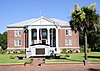 |
October 30, 1981 (#81000566) |
Russell St. 32°29′03″N 80°59′08″W / 32.484167°N 80.985556°W | Ridgeland | Built in 1915, designed by William Augustus Edwards |
| 6 | J.C. Richardson House | 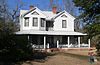 |
September 22, 2014 (#14000709) |
67 Gillison Branch Rd. 32°35′12″N 81°11′51″W / 32.5867°N 81.1974°W | Robertville | |
| 7 | Robertville Baptist Church | 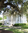 |
February 23, 1972 (#72001213) |
Junction of U.S. Route 321 and County Road 26 32°35′10″N 81°11′58″W / 32.586111°N 81.199444°W | Robertville | |
| 8 | Sinclair Service Station |  |
October 13, 2015 (#15000736) |
10782 Jacob Smart Blvd. 32°28′49″N 80°58′49″W / 32.48041°N 80.98024°W | Ridgeland | Restored and now houses the Morris Center for Lowcountry Heritage |
| 9 | Tillman School |  |
June 21, 2016 (#16000396) |
191 Cotton Hill Rd. – U.S. 321 32°27′57″N 81°06′33″W / 32.465837°N 81.109117°W | Tillman | |
| 10 | White Hall Plantation House Ruins and Oak Avenue |  |
October 27, 2000 (#98000423) |
Off South Carolina Highway 336, west of Old House[9] 32°28′07″N 80°55′28″W / 32.4686°N 80.9244°W | Ridgeland | Also known as Good Hope Plantation[10] |
Former listings edit
| [3] | Name on the Register | Image | Date listed | Date removed | Location | City or town | Description |
|---|---|---|---|---|---|---|---|
| 1 | Grays Consolidated High School |  |
September 21, 2007 (#07000986) | August 9, 2016 | U.S. Route 278 32°40′26″N 81°01′18″W / 32.673889°N 81.021667°W | Grays | Demolished in 2013 |
See also edit
Wikimedia Commons has media related to National Register of Historic Places in Jasper County, South Carolina.
References edit
- ^ The latitude and longitude information provided in this table was derived originally from the National Register Information System, which has been found to be fairly accurate for about 99% of listings. Some locations in this table may have been corrected to current GPS standards.
- ^ National Park Service, United States Department of the Interior, "National Register of Historic Places: Weekly List Actions", retrieved April 5, 2024.
- ^ a b Numbers represent an alphabetical ordering by significant words. Various colorings, defined here, differentiate National Historic Landmarks and historic districts from other NRHP buildings, structures, sites or objects.
- ^ "National Register Information System". National Register of Historic Places. National Park Service. March 13, 2009.
- ^ The eight-digit number below each date is the number assigned to each location in the National Register Information System database, which can be viewed by clicking the number.
- ^ Location derived from this map, furnished by the Library of Congress. The NRIS lists the site as "Address Restricted".
- ^ Location is for the Thomas Heyward grave, derived from Barefoot, Daniel W. Touring South Carolina's Revolutionary War Sites. Winston-Salem: John F. Blair, 1999, 110/112. The NRIS lists the site as "Address Restricted".
- ^ Old House Plantation, Jasper County, South Carolina Department of Archives and History, n.d. Accessed 2011-08-17.
- ^ Location derived from its GNIS feature record; the NRIS lists the site as "Address Restricted".
- ^ Fick, Sarah, and J. Tracy Power National Register of Historic Places Inventory/Nomination: White Hall Plantation House Ruins and Oak Avenue. National Park Service, 1974-01-22, 8.