


Summary
This is a list of the National Register of Historic Places listings in Kendall County, Texas.
This is intended to be a complete list of the properties and districts on the National Register of Historic Places in Kendall County, Texas. There are three districts and eight individual properties listed on the National Register in the county. One district includes two individual properties and contains several State Antiquities Landmarks and Recorded Texas Historic Landmarks. Outside of the district, three other properties are Recorded Texas Historic Landmarks.
This National Park Service list is complete through NPS recent listings posted April 5, 2024.[1]
Current listings edit
The locations of National Register properties and districts may be seen in a mapping service provided.[2]
| [3] | Name on the Register | Image | Date listed[4] | Location | City or town | Description |
|---|---|---|---|---|---|---|
| 1 | Otto Brinkmann House |  |
December 12, 1977 (#77001457) |
602 High St. 29°58′04″N 98°54′32″W / 29.967778°N 98.908889°W | Comfort | Part of Comfort Historic District; Recorded Texas Historic Landmark |
| 2 | Comfort Historic District |  |
May 29, 1979 (#79002989) |
State Highway 27; also roughly bounded by State Highway 27, Lindner Ave., Cypress Creek, 1st St., and Front St., 29°58′03″N 98°54′40″W / 29.9675°N 98.911111°W | Comfort | Specific boundaries represent a boundary increase of August 25, 2004; contains State Antiquities Landmarks, Recorded Texas Historic Landmarks |
| 3 | Joseph Dienger Building |  |
January 19, 1984 (#84001901) |
106 W. Blanco Rd. 29°47′40″N 98°43′55″W / 29.794444°N 98.731944°W | Boerne | Recorded Texas Historic Landmark |
| 4 | Gazebo for Albert Steves | 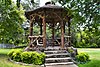 |
December 23, 2004 (#04001171) |
105 FM 473, at east portion of property 29°58′12″N 98°53′10″W / 29.96997°N 98.88603°W | Comfort | Gazebo at Haven River Inn Sculpture by Dionicio Rodriguez |
| 5 | Herff-Rozelle Farm | 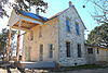 |
December 3, 2009 (#09000983) |
33 Herff Rd. 29°46′51″N 98°42′53″W / 29.780912°N 98.714636°W | Boerne | |
| 6 | Hygieostatic Bat Roost |  |
March 28, 1983 (#83003144) |
FM 473 E of Comfort 29°58′13″N 98°53′05″W / 29.9704°N 98.8847°W | Comfort | Recorded Texas Historic Landmark |
| 7 | Kendall County Courthouse and Jail | 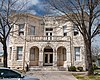 |
February 15, 1980 (#80004138) |
Public Sq. 29°47′40″N 98°43′50″W / 29.794444°N 98.730556°W | Boerne | State Antiquities Landmark, Recorded Texas Historic Landmark |
| 8 | Kendall Inn |  |
June 29, 1976 (#76002045) |
128 W Blanco Rd 29°47′38″N 98°44′00″W / 29.793889°N 98.733333°W | Boerne | Recorded Texas Historic Landmark |
| 9 | Sisterdale Valley District |  |
January 8, 1975 (#75001996) |
SR 1376 29°58′34″N 98°42′56″W / 29.976111°N 98.715556°W | Sisterdale | |
| 10 | Treue der Union Monument |  |
November 29, 1978 (#78002966) |
High St. between Third and Fourth 29°58′10″N 98°54′49″W / 29.969444°N 98.913611°W | Comfort | Part of Comfort Historic District; State Antiquities Landmark |
| 11 | Voelcker-Sueltenfuss House | October 10, 2017 (#100001722) |
82 Swede Springs Rd. 29°52′19″N 98°34′49″W / 29.871834°N 98.580403°W | Boerne |
See also edit
References edit
- ^ National Park Service, United States Department of the Interior, "National Register of Historic Places: Weekly List Actions", retrieved April 5, 2024.
- ^ The latitude and longitude information provided in this table was derived originally from the National Register Information System, which has been found to be fairly accurate for about 99% of listings. Some locations in this table may have been corrected to current GPS standards.
- ^ Numbers represent an alphabetical ordering by significant words. Various colorings, defined here, differentiate National Historic Landmarks and historic districts from other NRHP buildings, structures, sites or objects.
- ^ The eight-digit number below each date is the number assigned to each location in the National Register Information System database, which can be viewed by clicking the number.
External links edit
![]() Media related to National Register of Historic Places in Kendall County, Texas at Wikimedia Commons
Media related to National Register of Historic Places in Kendall County, Texas at Wikimedia Commons