
KNOWPIA
WELCOME TO KNOWPIA

National Register of Historic Places listings in Kent County, Delaware 
Summary
List of the National Register of Historic Places listings in Kent County, Delaware
This National Park Service list is complete through NPS recent listings posted April 12, 2024.[1]

Contents: Divisions in Delaware
| Wilmington (New Castle) | Northern New Castle | Southern New Castle | Kent | Sussex |
Current listings edit
| [2] | Name on the Register | Image | Date listed[3] | Location | City or town | Description |
|---|---|---|---|---|---|---|
| 1 | Allee House |  |
March 24, 1971 (#71000220) |
Off Delaware Route 9 on Dutch Neck Rd. 39°17′05″N 75°30′32″W / 39.284722°N 75.508889°W | Dutch Neck Crossroads | |
| 2 | Archeological Site K-875 (7K-D-37/C) | May 22, 1979 (#79003223) |
Address restricted | Kitts Hummock | ||
| 3 | Archeological Site K-873 (7K-D-35/A, B and D) | May 22, 1979 (#79003228) |
Address restricted | Magnolia | ||
| 4 | Archeological Site K-876 (7K-D-38/C) | May 22, 1979 (#79003222) |
Address restricted | Kitts Hummock | ||
| 5 | Archeological Site K-880 (7K-D-42/F) | May 22, 1979 (#79003225) |
Address restricted | Magnolia | ||
| 6 | Archeological Site K-891 (7K-D-45/A and B) | May 22, 1979 (#79003226) |
Address restricted | Magnolia | ||
| 7 | Archeological Site K-913 (7K-D-47/C, D and E) | May 22, 1979 (#79003229) |
Address restricted | Kitts Hummock | ||
| 8 | Archeological Site K-914 (7K-D-48/F and G) | May 22, 1979 (#79003221) |
Address restricted | Kitts Hummock | ||
| 9 | Archeological Site K-915 (7K-D-86/C) | May 22, 1979 (#79003224) |
Address restricted | Kitts Hummock | ||
| 10 | Archeological Site K-916 (7K-D-49/C) | May 22, 1979 (#79003230) |
Address restricted | Kitts Hummock | ||
| 11 | Archeological Site K-920 (7K-D-52/A and C) | May 22, 1979 (#79003227) |
Address restricted | Kitts Hummock | ||
| 12 | Archeological Site No. 7K F 4 and 23 | June 3, 1982 (#82002320) |
Address restricted | Milford | ||
| 13 | George Arnold House | June 27, 1983 (#83001360) |
7 Hickories Road 39°13′22″N 75°39′19″W / 39.222648°N 75.655296°W | Kenton | Demolished in 2001 | |
| 14 | Aspendale |  |
April 15, 1970 (#70000170) |
1 mile west of Kenton on Delaware Route 300 39°13′18″N 75°41′09″W / 39.221667°N 75.685833°W | Kenton | |
| 15 | Thomas Attix House |  |
June 27, 1983 (#83001361) |
Road 140 39°13′31″N 75°42′28″W / 39.225278°N 75.707778°W | Kenton | |
| 16 | Bank House |  |
July 31, 1978 (#78000890) |
119 N. Walnut St. 38°54′55″N 75°25′43″W / 38.915278°N 75.428611°W | Milford | |
| 17 | Bannister Hall and Baynard House |  |
April 11, 1973 (#73000503) |
South of Smyrna off Delaware Route 300 39°17′22″N 75°37′19″W / 39.289444°N 75.621944°W | Smyrna | |
| 18 | Barratt Hall | 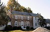 |
April 13, 1973 (#73000492) |
South of Frederica off Road 372 39°01′29″N 75°26′24″W / 39.024722°N 75.44°W | Frederica | |
| 19 | Barratt's Chapel |  |
October 10, 1972 (#72000281) |
North of Frederica on Delaware Route 1 39°01′29″N 75°27′34″W / 39.024722°N 75.459444°W | Frederica | |
| 20 | Belmont Hall |  |
December 16, 1971 (#71000223) |
217 Smyrna-Leipsic Rd. 39°17′40″N 75°35′45″W / 39.294501°N 75.595902°W | Smyrna | |
| 21 | Bethel Methodist Protestant Church |  |
September 14, 1998 (#98001093) |
Junction of Roads 61, 114, and 304 38°51′49″N 75°38′13″W / 38.863611°N 75.636944°W | Andrewville | |
| 22 | J. F. Betz House |  |
August 29, 1983 (#83001362) |
Delaware Route 6 39°17′02″N 75°40′29″W / 39.283889°N 75.674722°W | Kenton | |
| 23 | Benjamin Blackiston House |  |
June 27, 1983 (#83001363) |
Off Delaware Route 6 39°15′07″N 75°44′13″W / 39.251944°N 75.736944°W | Kenton | |
| 24 | Bonwell House |  |
March 20, 1973 (#73000493) |
4 miles west of Frederica on Road 380 39°01′23″N 75°30′34″W / 39.023056°N 75.509444°W | Frederica | |
| 25 | Bradford-Loockerman House |  |
November 30, 1972 (#72000277) |
419 S. State St. 39°09′19″N 75°31′24″W / 39.155278°N 75.523333°W | Dover | |
| 26 | Brecknock |  |
December 24, 1974 (#74000596) |
0.5 miles north of Camden off U.S. Route 13 39°07′26″N 75°32′10″W / 39.123889°N 75.536111°W | Camden | |
| 27 | Building 1301, Dover Air Force Base |  |
December 7, 1994 (#94001377) |
Dover AFB, E. Dover Hundred 39°07′07″N 75°27′24″W / 39.1187°N 75.4567°W | Dover | |
| 28 | John Bullen House |  |
April 14, 1975 (#75000542) |
214 S. State St. 39°14′27″N 75°31′28″W / 39.24092°N 75.52439°W | Dover | |
| 29 | W. D. Burrows House |  |
June 27, 1983 (#83001364) |
Delaware Route 42 39°14′10″N 75°40′30″W / 39.236111°N 75.675°W | Kenton | |
| 30 | Byfield Historic District | May 22, 1979 (#79003232) |
Address restricted | Kitts Hummock | ||
| 31 | Byrd's AME Church |  |
October 19, 1982 (#82001023) |
Smyrna Ave. 39°17′32″N 75°37′38″W / 39.292222°N 75.627222°W | Clayton | |
| 32 | Camden Friends Meetinghouse |  |
April 3, 1973 (#73000485) |
Commerce St. 39°06′52″N 75°32′54″W / 39.114444°N 75.548333°W | Camden | |
| 33 | Camden Historic District |  |
September 17, 1974 (#74000595) |
Both sides of Camden-Wyoming Ave. and Main St. 39°06′49″N 75°32′34″W / 39.113611°N 75.542778°W | Camden | |
| 34 | Carey Farm Site | October 20, 1977 (#77000384) |
Address restricted | Dover | ||
| 35 | Cherbourg Round Barn |  |
December 22, 1978 (#78000888) |
Southwest of Little Creek off Delaware Route 9 39°09′04″N 75°27′27″W / 39.151111°N 75.4575°W | Little Creek | |
| 36 | Scene of Cheyney Clow's Rebellion |  |
January 14, 1974 (#74000598) |
West of Kenton on Delaware Route 300 39°12′15″N 75°44′35″W / 39.204167°N 75.743056°W | Kenton | |
| 37 | Christ Church |  |
May 8, 1973 (#73000502) |
3rd and Church Sts. 38°54′56″N 75°25′55″W / 38.915556°N 75.431944°W | Milford | |
| 38 | Christ Church | 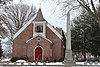 |
December 4, 1972 (#72001500) |
S. State and Water Sts. 39°09′16″N 75°31′20″W / 39.154444°N 75.522222°W | Dover | |
| 39 | Clark-Pratt House |  |
June 27, 1983 (#83001365) |
Main St. 39°13′34″N 75°40′39″W / 39.226111°N 75.6775°W | Kenton | |
| 40 | Clayton Railroad Station |  |
November 6, 1986 (#86003066) |
Bassett St. 39°17′28″N 75°38′00″W / 39.291111°N 75.633333°W | Clayton | |
| 41 | Coombe Historic District |  |
April 8, 1982 (#82002313) |
West of Felton on Delaware Route 12 and Road 281 39°00′09″N 75°37′10″W / 39.0025°N 75.619444°W | Felton | |
| 42 | Cooper House |  |
March 20, 1973 (#73000495) |
Delaware Route 300 39°13′40″N 75°39′49″W / 39.227778°N 75.663611°W | Kenton | |
| 43 | Thomas B. Coursey House |  |
July 23, 1990 (#90001069) |
5578 Canterbury Road 38°59′27″N 75°30′42″W / 38.990833°N 75.511667°W | Felton | |
| 44 | Cow Marsh Old School Baptist Church |  |
June 24, 1976 (#76000571) |
Northeast of Sandtown on Delaware Route 10 39°02′31″N 75°41′42″W / 39.041944°N 75.695°W | Sandtown | |
| 45 | David J. Cummins House |  |
October 6, 1983 (#83003504) |
587 Smyrna-Leipsic Rd. 39°17′37″N 75°35′16″W / 39.293745°N 75.587835°W | Smyrna (Duck Creek Hundred) | |
| 46 | Timothy Cummins House |  |
October 6, 1983 (#83003505) |
3411 Smyrna-Lepsic Rd. 39°16′45″N 75°32′25″W / 39.279134°N 75.540205°W | Smyrna (Duck Creek Hundred) | |
| 47 | Thomas Davis House | 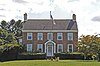 |
February 28, 1983 (#83001366) |
Delaware Route 6 39°17′15″N 75°39′26″W / 39.2875°N 75.657222°W | Kenton | |
| 48 | Delaware Boundary Markers |  |
February 18, 1975 (#75002101) |
State line separating Delaware from Maryland and Pennsylvania | Multiple | Extends into bordering counties in eastern Maryland and southeastern Pennsylvania. |
| 49 | Delaware State Museum Buildings | 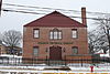 |
February 1, 1972 (#72000278) |
316 S. Governors Ave. 39°09′22″N 75°31′39″W / 39.156111°N 75.5275°W | Dover | |
| 50 | T.H. Denny House |  |
June 27, 1983 (#83001367) |
2466 7 Hickories Road 39°12′46″N 75°37′22″W / 39.212717°N 75.622856°W | Kenton | |
| 51 | John Dickinson House |  |
October 15, 1966 (#66000258) |
5 miles southeast of Dover and 3 miles east of U.S. Route 13 on Kitts Hummock Rd. 39°06′09″N 75°26′55″W / 39.1025°N 75.448611°W | Dover | |
| 52 | Dill Farm Site | October 2, 1978 (#78000893) |
Address restricted | Sandtown | ||
| 53 | Dover Green Historic District |  |
May 5, 1977 (#77000383) |
Bounded by Governors Ave., North, South, and East Sts. 39°09′17″N 75°31′26″W / 39.154722°N 75.523889°W | Dover | |
| 54 | N. C. Downs House |  |
June 27, 1983 (#83001368) |
Road 141 39°14′04″N 75°42′03″W / 39.234444°N 75.700833°W | Kenton | |
| 55 | Downtown Harrington Historic District |  |
June 20, 2019 (#100004082) |
Various 38°55′25″N 75°34′42″W / 38.9236°N 75.5782°W | Harrington | |
| 56 | Duck Creek Village |  |
February 1, 1972 (#72000282) |
Road 65 between Duck Creek and Green's Branch 39°18′28″N 75°37′15″W / 39.307778°N 75.620833°W | Smyrna | |
| 57 | Durham-Shores House | September 21, 2001 (#01001005) |
Eastern side of Delaware Route 15 39°11′46″N 75°33′49″W / 39.196111°N 75.563611°W | Dupont Station | ||
| 58 | Eden Hill |  |
May 8, 1973 (#73000487) |
Western end of Water St. 39°09′05″N 75°32′13″W / 39.151389°N 75.536944°W | Dover | |
| 59 | Felton Historic District |  |
January 26, 1988 (#87002433) |
Roughly bounded by North, Walnut, Main, and Niles Sts. 39°00′27″N 75°34′56″W / 39.0075°N 75.582222°W | Felton | Consists of buildings completed between 1856 and 1940, encompassing much of downtown. |
| 60 | Felton Railroad Station |  |
July 13, 1981 (#81000191) |
E. Railroad Ave. 39°00′39″N 75°34′33″W / 39.010815°N 75.575802°W | Felton | |
| 61 | Fennimore Store |  |
May 24, 1982 (#82002314) |
Main, Lombard, and Front Sts. 39°14′27″N 75°30′51″W / 39.240833°N 75.514167°W | Leipsic | |
| 62 | Fourteen Foot Bank Light |  |
March 27, 1989 (#89000286) |
On Fourteen Foot Bank in Delaware Bay, 12 miles east of Bowers 39°02′54″N 75°10′57″W / 39.048333°N 75.1825°W | Delaware Bay (Bowers) | |
| 63 | Frederica Historic District |  |
November 9, 1977 (#77000385) |
Market, Front, and David Sts. 39°00′27″N 75°28′03″W / 39.0075°N 75.4675°W | Frederica | |
| 64 | Vincelette Futuro House | December 26, 2023 (#100009680) |
4388 Deep Grass Lane 38°55′13″N 75°30′55″W / 38.9202°N 75.5152°W | Houston | ||
| 65 | George Farmhouse |  |
October 19, 1982 (#82001862) |
2615 Woodland Beach Rd. 39°18′41″N 75°32′57″W / 39.311337°N 75.549174°W | Smyrna (Duck Creek Hundred) | |
| 66 | Golden Mine | August 24, 1978 (#78000891) |
West of Milford on Road 443 38°54′19″N 75°29′08″W / 38.905278°N 75.485556°W | Milford | ||
| 67 | Governor's House |  |
December 5, 1972 (#72000279) |
Kings Hwy. 39°09′41″N 75°31′25″W / 39.161389°N 75.523611°W | Dover | |
| 68 | Great Geneva |  |
March 26, 1973 (#73000489) |
3 miles south of Dover on Road 356 39°07′03″N 75°30′32″W / 39.1175°N 75.508889°W | Camden | |
| 69 | Green Mansion House |  |
June 27, 1983 (#83001369) |
Main St. 39°13′37″N 75°40′37″W / 39.226944°N 75.676944°W | Kenton | |
| 70 | Greenwold |  |
March 20, 1973 (#73000488) |
625 S. State St. 39°09′06″N 75°31′19″W / 39.151667°N 75.521944°W | Dover | Demolished 2023 |
| 71 | Griffith's Chapel |  |
October 29, 1983 (#83001370) |
Junction of Roads 442 and 443 38°53′45″N 75°30′30″W / 38.895833°N 75.508333°W | Williamsville | |
| 72 | Robert Hill House | August 29, 1983 (#83001371) |
Delaware Route 6 39°16′33″N 75°41′21″W / 39.275833°N 75.689167°W | Kenton | Demolished between 2009 and 2011. | |
| 73 | Hoffecker-Lockwood House |  |
June 27, 1983 (#83001372) |
Delaware Route 6 39°13′36″N 75°35′53″W / 39.226667°N 75.598056°W | Kenton | Demolished between 1983 and 1992. |
| 74 | Alfred L. Hudson House |  |
June 27, 1983 (#83001373) |
Road 90 39°16′10″N 75°37′24″W / 39.269444°N 75.623333°W | Kenton | |
| 75 | Hughes Early Man Sites | July 24, 1979 (#79000623) |
Address restricted | Felton | ||
| 76 | Hughes-Willis Site | November 21, 1978 (#78000887) |
Address restricted | Dover | ||
| 77 | Island Field Site | February 1, 1972 (#72000283) |
South of the mouth of the Murderkill River, near Delaware Bay[4]: 146 39°02′34″N 75°23′17″W / 39.042778°N 75.388056°W | South Bowers | Includes the site of a village occupied during the ninth century AD[4]: 157 | |
| 78 | Ivy Dale Farm |  |
April 24, 1973 (#73000504) |
1101 Smyrna-Leipsic Rd. 39°17′13″N 75°34′46″W / 39.286834°N 75.579573°W | Smyrna (Duck Creek Hundred) | |
| 79 | Enoch Jones House |  |
June 19, 1973 (#73000486) |
Southwest of Clayton off Delaware Route 300 39°16′45″N 75°39′37″W / 39.279167°N 75.660278°W | Clayton | |
| 80 | KATHERINE M. LEE (Schooner) | April 25, 1983 (#83001375) |
Fox's Dock at Front and Lombard Sts. 39°14′31″N 75°30′51″W / 39.241944°N 75.514167°W | Leipsic | ||
| 81 | Kenton Historic District |  |
August 29, 1983 (#83001396) |
Commerce St. 39°13′36″N 75°39′13″W / 39.226667°N 75.653611°W | Kenton | |
| 82 | Kenton Post Office |  |
June 27, 1983 (#83001376) |
Main St. 39°13′38″N 75°39′54″W / 39.227222°N 75.665°W | Kenton | |
| 83 | Thomas Lamb Farm | August 29, 1983 (#83001374) |
Road 130 39°17′35″N 75°41′04″W / 39.293056°N 75.684444°W | Kenton | ||
| 84 | Thomas Lamb House |  |
August 29, 1983 (#83001385) |
Roads 129 and 130 39°16′53″N 75°42′26″W / 39.281389°N 75.707222°W | Kenton | House and milk house demolished; barn remains. |
| 85 | Alexander Laws House |  |
April 25, 1983 (#83001377) |
Front and Walnut Sts. 39°14′27″N 75°31′00″W / 39.240833°N 75.516667°W | Leipsic | |
| 86 | Lewis Family Tenant Agricultural Complex |  |
August 13, 1986 (#86001506) |
Road 227 39°06′15″N 75°36′30″W / 39.104167°N 75.608333°W | Wyoming | |
| 87 | Jefferson Lewis House |  |
June 27, 1983 (#83001349) |
2191 Seeneytown Road 39°12′48″N 75°37′58″W / 39.213297°N 75.632669°W | Kenton | |
| 88 | John B. Lindale House |  |
May 8, 1973 (#73002231) |
24 Walnut St. 39°04′12″N 75°29′11″W / 39.07°N 75.486389°W | Magnolia | |
| 89 | Little Creek Hundred Rural Historic District | November 7, 1984 (#84000286) |
Delaware Route 9 39°10′47″N 75°28′31″W / 39.179722°N 75.475278°W | Little Creek | ||
| 90 | Little Creek Methodist Church |  |
May 24, 1982 (#82002316) |
Main St. 39°09′49″N 75°26′49″W / 39.163611°N 75.446944°W | Little Creek | |
| 91 | Peter Lofland House |  |
April 22, 1982 (#82002321) |
417 N. Walnut St. 38°55′03″N 75°25′43″W / 38.9175°N 75.428611°W | Milford | |
| 92 | Logan School House K-834 | May 22, 1979 (#79003231) |
Road 68 39°06′01″N 75°25′49″W / 39.100278°N 75.430278°W | Kitts Hummock | ||
| 93 | Loockerman Hall |  |
June 21, 1971 (#71000218) |
Delaware State University campus 39°11′06″N 75°32′44″W / 39.185°N 75.545556°W | Dover | |
| 94 | Matthew Lowber House |  |
April 16, 1971 (#71000221) |
East of Main St. 39°04′21″N 75°28′50″W / 39.0725°N 75.480556°W | Magnolia | |
| 95 | Lower St. Jones Neck Historic District |  |
May 22, 1979 (#79003233) |
Address restricted | Kitts Hummock | |
| 96 | Macomb Farm |  |
December 2, 1974 (#74000597) |
Long Point Rd. off Delaware Route 8 39°10′58″N 75°28′38″W / 39.182778°N 75.477222°W | Dover | |
| 97 | MAGGIE S. MYERS (schooner) | April 25, 1983 (#83001378) |
Killen's Dock at Front and Lombard Sts. 39°14′30″N 75°30′53″W / 39.241667°N 75.514722°W | Leipsic | ||
| 98 | McClary House |  |
April 25, 1983 (#83001353) |
Main and McClary Sts. 39°14′23″N 75°30′49″W / 39.239722°N 75.513611°W | Leipsic | |
| 99 | James McColley House |  |
January 7, 1983 (#83001354) |
500-502 NW. Front St. 38°54′46″N 75°26′07″W / 38.912778°N 75.435278°W | Milford | |
| 100 | Delaplane McDaniel House | June 27, 1983 (#83001379) |
Road 92 39°13′36″N 75°35′53″W / 39.226667°N 75.598056°W | Kenton | ||
| 101 | Mifflin-Marim Agricultural Complex |  |
November 7, 1984 (#84000269) |
Delaware Route 9 39°12′40″N 75°30′06″W / 39.211111°N 75.501667°W | Dover | |
| 102 | Mount Pleasant |  |
September 11, 1992 (#92001134) |
5 Margie Dr. 39°16′38″N 75°36′27″W / 39.277260°N 75.607507°W | Smyrna | |
| 103 | Milford New Century Club |  |
April 22, 1982 (#82002322) |
6 S. Church Ave. 38°54′44″N 75°25′53″W / 38.912222°N 75.431389°W | Milford | |
| 104 | Mill House |  |
January 7, 1983 (#83001380) |
414 NW. Front St. 38°54′47″N 75°26′05″W / 38.913056°N 75.434722°W | Milford | |
| 105 | Moore House |  |
October 19, 1982 (#82001022) |
511 W. Mt. Vernon St. 39°17′45″N 75°36′51″W / 39.295944°N 75.614211°W | Smyrna | |
| 106 | Mordington |  |
April 13, 1973 (#73000494) |
South of Frederica on Canterbury Rd. 38°58′07″N 75°29′39″W / 38.968611°N 75.494167°W | Frederica | |
| 107 | North Milford Historic District |  |
January 7, 1983 (#83001357) |
Roughly bounded by Mispillion River, Silver Lake, N. Walnut and NW. 3rd Sts. 38°54′53″N 75°25′52″W / 38.914722°N 75.431111°W | Milford | |
| 108 | Octagonal Schoolhouse | 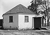 |
March 24, 1971 (#71000217) |
East of Cowgill 39°11′44″N 75°28′21″W / 39.195556°N 75.4725°W | Cowgill's Corner | |
| 109 | Old Fire House |  |
January 7, 1983 (#83001381) |
Church Ave. 38°54′52″N 75°25′50″W / 38.914444°N 75.430556°W | Milford | |
| 110 | Old Statehouse | 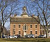 |
February 24, 1971 (#71000219) |
The Green 39°09′23″N 75°31′23″W / 39.156389°N 75.523056°W | Dover | |
| 111 | Old Stone Tavern |  |
July 2, 1973 (#73000499) |
Main St. 39°09′51″N 75°26′51″W / 39.164167°N 75.4475°W | Little Creek | |
| 112 | Palmer Home |  |
September 13, 1988 (#88001443) |
115 American Ave. 39°09′50″N 75°31′31″W / 39.163889°N 75.525278°W | Dover | |
| 113 | Peterson and Mustard's Hermitage Farm |  |
October 26, 1982 (#82001027) |
1653 Big Oak Rd. 39°17′29″N 75°34′10″W / 39.291282°N 75.569403°W | Smyrna | |
| 114 | Poinsett House |  |
June 27, 1983 (#83001350) |
Delaware Route 6 39°15′46″N 75°44′34″W / 39.262778°N 75.742778°W | Kenton | |
| 115 | Port Mahon Lighthouse |  |
October 25, 1979 (#79000624) |
Northeast of Little Creek 39°11′05″N 75°24′04″W / 39.184722°N 75.401111°W | Little Creek | |
| 116 | Rawley House |  |
April 25, 1983 (#83001352) |
Main St. 39°14′26″N 75°30′51″W / 39.240556°N 75.514167°W | Leipsic | |
| 117 | Raymond Neck Historic District | 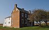 |
November 8, 1982 (#82001026) |
North of Leipsic between Leipsic River and Road 85 39°14′53″N 75°30′32″W / 39.248056°N 75.508889°W | Leipsic | |
| 118 | Reed House |  |
April 25, 1983 (#83001351) |
Lombard St. 39°14′31″N 75°30′47″W / 39.241944°N 75.513056°W | Leipsic | |
| 119 | Jehu Reed House |  |
June 4, 1973 (#73000500) |
Delaware Route 1 39°02′30″N 75°27′27″W / 39.041667°N 75.4575°W | Little Heaven | |
| 120 | Ruth Mansion House |  |
April 11, 1973 (#73000496) |
Main St. 39°14′25″N 75°30′51″W / 39.240278°N 75.514167°W | Leipsic | |
| 121 | St. Paul A.M.E. Church | 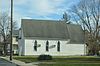 |
October 17, 2016 (#16000726) |
103 W. Mispillion St. 38°55′21″N 75°34′58″W / 38.922394°N 75.582739°W | Harrington | |
| 122 | St. Joseph's Industrial School |  |
December 12, 2002 (#02001491) |
355 W. Duck Creek Rd. 39°17′37″N 75°38′13″W / 39.293611°N 75.636944°W | Clayton | |
| 123 | St. Stephen's P.E. Church | 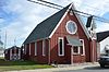 |
October 8, 2014 (#14000825) |
110 Fleming St. 38°55′30″N 75°34′42″W / 38.9250°N 75.5784°W | Harrington | |
| 124 | Savin-Wilson House | 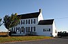 |
September 11, 1992 (#92001135) |
551 Hurd Rd. 39°17′11″N 75°32′07″W / 39.286474°N 75.535345°W | Smyrna (Duck Creek Hundred) | |
| 125 | Saxton United Methodist Church |  |
July 23, 1990 (#90001070) |
Junction of Main and Church Sts. 39°03′30″N 75°24′14″W / 39.058333°N 75.403889°W | Bowers | |
| 126 | Short's Landing Hotel Complex |  |
October 17, 1983 (#83003506) |
6180 Hay Point Landing Road 39°20′49″N 75°32′12″W / 39.346959°N 75.536639°W | Smyrna | |
| 127 | Sipple House |  |
May 24, 1982 (#82002315) |
Denny and Front Sts. 39°14′27″N 75°31′04″W / 39.240833°N 75.517778°W | Leipsic | |
| 128 | Smyrna Historic District |  |
May 23, 1980 (#80000930) |
Delaware Route 6 and U.S. Route 13 39°17′59″N 75°36′24″W / 39.299722°N 75.606667°W | Smyrna | |
| 129 | Snowland |  |
March 20, 1973 (#73000497) |
Delaware Route 42 39°13′46″N 75°31′39″W / 39.229444°N 75.5275°W | Leipsic | |
| 130 | Somerville |  |
December 31, 1974 (#74000599) |
1073 7 Hickories Road 39°13′18″N 75°38′45″W / 39.221536°N 75.645967°W | Kenton | |
| 131 | Star Hill AME Church |  |
November 25, 1994 (#94001389) |
Road 366 southeast of Camden 39°06′06″N 75°32′10″W / 39.101667°N 75.536111°W | Camden | |
| 132 | William Stevens House | August 29, 1983 (#83001406) |
Delaware Route 6 39°16′33″N 75°40′30″W / 39.275833°N 75.675°W | Kenton | Demolished February 2001. | |
| 133 | Elizabeth Stubbs House | May 24, 1982 (#82002317) |
Main St. 39°09′48″N 75°26′51″W / 39.163333°N 75.4475°W | Little Creek | ||
| 134 | Thomas Sutton House |  |
April 11, 1973 (#73000505) |
Florio Road 39°19′31″N 75°30′22″W / 39.325278°N 75.506111°W | Woodland Beach | |
| 135 | Tharp House |  |
March 20, 1973 (#73000491) |
East of Farmington on U.S. Route 13 38°52′17″N 75°34′35″W / 38.871389°N 75.576389°W | Farmington | |
| 136 | Thomas' Methodist Episcopal Chapel | 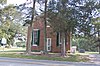 |
January 26, 1994 (#93001516) |
Road 206 west of Chapeltown, West Dover Hundred 39°05′55″N 75°42′15″W / 39.098611°N 75.704167°W | Chapeltown | |
| 137 | Parson Thorne Mansion | 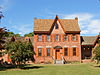 |
June 21, 1971 (#71000222) |
501 NW. Front St. 38°54′49″N 75°26′07″W / 38.913611°N 75.435278°W | Milford | |
| 138 | Todd's Chapel | 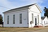 |
September 14, 1998 (#98001094) |
Junction of Todd's Chapel Rd., and Hickman Rd. 38°50′07″N 75°40′25″W / 38.835278°N 75.673611°W | Greenwood | |
| 139 | Town Point | 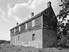 |
December 5, 1972 (#72000280) |
Kitts Hummock Rd. 39°04′53″N 75°25′44″W / 39.081389°N 75.428889°W | Dover | |
| 140 | Gov. George Truitt House |  |
December 12, 1978 (#78000889) |
Southwest of Magnolia on Road 388 39°01′10″N 75°32′18″W / 39.019444°N 75.538333°W | Magnolia | |
| 141 | Tyn Head Court |  |
March 1, 1973 (#73000490) |
East of Dover on S. Little Creek Rd. 39°09′15″N 75°28′36″W / 39.154167°N 75.476667°W | Dover | |
| 142 | Victorian Dover Historic District |  |
July 16, 1979 (#79000622) |
Roughly bounded by Silver Lake, St. Jones River, North and Queen Sts. 39°09′51″N 75°31′35″W / 39.164167°N 75.526389°W | Dover | |
| 143 | Vogl House | 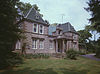 |
November 7, 1976 (#76000570) |
West of Masten 38°57′52″N 75°37′44″W / 38.964444°N 75.628889°W | Masten's Corner | |
| 144 | John M. Voshell House | 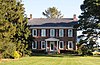 |
October 6, 1983 (#83003507) |
887 Hawkey Branch Rd. 39°18′05″N 75°31′06″W / 39.301491°N 75.518210°W | Smyrna (Duck Creek Hundred) | |
| 145 | Walnut Farm |  |
November 10, 1982 (#82001025) |
Roosa Rd. 38°55′39″N 75°26′09″W / 38.9275°N 75.435833°W | Milford | |
| 146 | Gov. William T. Watson Mansion |  |
April 22, 1982 (#82002323) |
600 N. Walnut St. 38°55′12″N 75°25′47″W / 38.92°N 75.429722°W | Milford | |
| 147 | Wheel of Fortune |  |
April 11, 1973 (#73000498) |
South of Leipsic off Delaware Route 9 39°12′53″N 75°30′46″W / 39.214722°N 75.512778°W | Leipsic | |
| 148 | White-Warren Tenant House |  |
September 21, 2001 (#01001009) |
Northeastern side of Road 261 39°00′56″N 75°40′15″W / 39.015556°N 75.670833°W | Sandtown | |
| 149 | J. H. Wilkerson & Son Brickworks |  |
July 12, 1978 (#78000892) |
Off Road 409 38°55′08″N 75°24′50″W / 38.918889°N 75.413889°W | Milford | Listed as destroyed or demolished |
| 150 | James Williams House |  |
June 27, 1983 (#83001382) |
1064 7 Hickories Road 39°13′12″N 75°38′48″W / 39.220030°N 75.646671°W | Kenton | |
| 151 | Woodlawn |  |
October 19, 1982 (#82001863) |
1165 DuPont Blvd. 39°17′15″N 75°35′39″W / 39.287570°N 75.594175°W | Smyrna (Duck Creek Hundred) | Demolished July 14th, 2017 |
| 152 | Jonathan Woodley House | 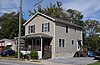 |
May 24, 1982 (#82002318) |
Main St. 39°09′46″N 75°26′48″W / 39.162778°N 75.446667°W | Little Creek | |
| 153 | Woodside Methodist Episcopal Church |  |
February 16, 1996 (#96000107) |
Main St., North Murderkill Hundred 39°04′19″N 75°34′03″W / 39.071944°N 75.5675°W | Woodside | |
| 154 | Wright-Carry House | June 27, 1983 (#83001383) |
Commerce St. 39°13′35″N 75°39′56″W / 39.226389°N 75.665556°W | Kenton | ||
| 155 | Wyoming Historic District |  |
February 18, 1987 (#86003037) |
Roughly bounded by Front St., Caesar Rodney Ave., Southern Blvd., and Mechanic St. 39°07′11″N 75°33′29″W / 39.119722°N 75.558056°W | Wyoming | |
| 156 | Wyoming Railroad Station |  |
December 4, 1980 (#80000931) |
1 N. Railroad Ave. 39°07′06″N 75°33′32″W / 39.118375°N 75.558864°W | Wyoming | |
| 157 | Zion African Methodist Episcopal Church | 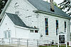 |
November 25, 1994 (#94001388) |
Center St. 39°07′01″N 75°33′05″W / 39.116944°N 75.551389°W | Camden |
Former listing edit
| [2] | Name on the Register | Image | Date listed | Date removed | Location | City or town | Description |
|---|---|---|---|---|---|---|---|
| 1 | Governor John Cook House | October 6, 1983 (#83003503) | June 5, 1986 | S of Smyrna | Smyrna | Birthplace of former Delaware Governor John Cook. Removed after being relocated to the National Building Museum in Washington, DC. |
References edit
- ^ National Park Service, United States Department of the Interior, "National Register of Historic Places: Weekly List Actions", retrieved April 12, 2024.
- ^ a b Numbers represent an alphabetical ordering by significant words. Various colorings, defined here, differentiate National Historic Landmarks and historic districts from other NRHP buildings, structures, sites or objects.
- ^ The eight-digit number below each date is the number assigned to each location in the National Register Information System database, which can be viewed by clicking the number.
- ^ a b Custer, Jay F., et al. "A Re-Examination of the Island Field Site (7K-F-17), Kent County, Delaware". Archaeology of Eastern North America 18 (1990): 145-212.
Wikimedia Commons has media related to National Register of Historic Places in Kent County, Delaware.