


Summary
This is a list of the National Register of Historic Places listings in Kittitas County, Washington.
This is intended to be a complete list of the properties and districts on the National Register of Historic Places in Kittitas County, Washington, United States. Latitude and longitude coordinates are provided for many National Register properties and districts; these locations may be seen together in a map.[1]
There are 25 properties and districts listed on the National Register in the county. Another property was once listed but has been removed.
This National Park Service list is complete through NPS recent listings posted April 5, 2024.[2]
Current listings edit
| [3] | Name on the Register[4] | Image | Date listed[5] | Location | City or town | Description |
|---|---|---|---|---|---|---|
| 1 | Beverly Railroad Bridge |  |
July 16, 1982 (#82004214) |
Spans Columbia River 46°49′52″N 119°56′54″W / 46.831111°N 119.948333°W | Beverly | Historic Bridges and Tunnels in Washington TR |
| 2 | Cabin Creek Historic District |  |
August 17, 1979 (#79002545) |
West of Easton 47°14′24″N 121°13′46″W / 47.24°N 121.229444°W | Easton | |
| 3 | Chicago, Milwaukee, St. Paul & Pacific Railroad-Kittitas Depot |  |
November 19, 1992 (#92001582) |
Junction of Railroad Aveve and Main Street 46°59′03″N 120°25′05″W / 46.984167°N 120.418056°W | Kittitas | Historic Resources of the Milwaukee Road in Washington, 1909-1945 MPS |
| 4 | Chicago, Milwaukee, St. Paul and Pacific Railroad: South Cle Elum Yard |  |
April 25, 2003 (#03000305) |
Near Milwaukee Road and Reservoir Canyon Road 47°10′58″N 120°57′24″W / 47.182778°N 120.956667°W | South Cle Elum | Historic Resources of the Milwaukee Road in Washington, 1909-1945 MPS |
| 5 | Cle Elum-Roslyn Beneficial Association Hospital |  |
December 3, 1980 (#80004005) |
505 Power Street 47°11′48″N 120°56′40″W / 47.196667°N 120.944444°W | Cle Elum | |
| 6 | Downtown Ellensburg Historic District | 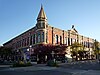 |
July 1, 1977 (#77001341) |
Roughly bounded by 3rd and 6th Avenues, and Main and Ruby Streets 46°59′46″N 120°32′45″W / 46.996111°N 120.545833°W | Ellensburg | Includes 1890-built Masonic Temple (Ellensburg, Washington)[6][7] |
| 7 | First Railroad Addition Historic District | 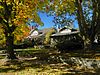 |
May 8, 1987 (#87000722) |
Roughly bounded by Tenth Avenue, D Street, Ninth Avenue, and A Street 47°00′05″N 120°32′41″W / 47.001389°N 120.544722°W | Ellensburg | |
| 8 | Dr. Paschal and Agnes Gray House |  |
August 29, 1997 (#97001079) |
606 North Main Street 46°58′16″N 120°32′55″W / 46.971111°N 120.548611°W | Ellensburg | |
| 9 | Kittitas County Fairgrounds | 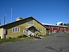 |
January 8, 1999 (#98001594) |
512 North Poplar Street 46°59′55″N 120°31′58″W / 46.99872°N 120.53286°W | Ellensburg | |
| 10 | Lake Keechelus Snowshed Bridge |  |
May 24, 1995 (#95000627) |
I-90 near Snoqualmie Pass 47°21′20″N 121°21′53″W / 47.355556°N 121.364722°W | Hyak | Bridges of Washington State MPS, demolished April 2014 |
| 11 | Liberty Historic District | 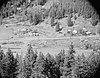 |
October 15, 1974 (#74001965) |
Both sides of Williams Creek Wagon Rd. 47°15′15″N 120°39′53″W / 47.254167°N 120.664722°W | Liberty | |
| 12 | Milwaukee Road Bunkhouse | 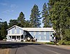 |
March 31, 1989 (#89000210) |
526 Marie 47°10′58″N 120°57′12″W / 47.182778°N 120.953333°W | South Cle Elum | |
| 13 | Albert Nelson Farmstead |  |
February 25, 1982 (#82004258) |
Manastash Road 46°58′17″N 120°36′38″W / 46.971389°N 120.610556°W | Ellensburg | |
| 14 | Northern Pacific Railway Passenger Depot |  |
September 26, 1991 (#91001438) |
606 W. Third St. 46°59′40″N 120°33′25″W / 46.994444°N 120.556944°W | Ellensburg | |
| 15 | Northwestern Improvement Company Store |  |
April 13, 1973 (#73001881) |
1st Street and Pennsylvania Avenue 47°13′25″N 120°59′29″W / 47.223611°N 120.991389°W | Roslyn | |
| 16 | Olmstead Place State Park | 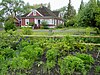 |
March 31, 1971 (#71000878) |
4 miles east of Ellensburg near the Kittitas Highway 46°58′42″N 120°28′15″W / 46.978333°N 120.470833°W | Ellensburg | |
| 17 | Ramsay House |  |
May 2, 1986 (#86000957) |
215 East Ninth 47°00′06″N 120°34′06″W / 47.001667°N 120.568333°W | Ellensburg | |
| 18 | Roslyn Historic District | 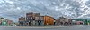 |
February 14, 1978 (#78002760) |
WA 2E 47°13′19″N 120°59′28″W / 47.221944°N 120.991111°W | Roslyn | |
| 19 | Salmon la Sac Guard Station |  |
July 15, 1974 (#74001964) |
North of Cle Elum in Wenatchee National Forest 47°24′07″N 121°05′39″W / 47.401944°N 121.094167°W | Cle Elum | |
| 20 | Shoudy House |  |
November 12, 1992 (#92001585) |
309 West Fifth Avenue 46°59′49″N 120°32′59″W / 46.996944°N 120.549722°W | Ellensburg | |
| 21 | Springfield Farm | April 13, 1977 (#77001342) |
9 miles north of Ellensburg 47°07′53″N 120°35′10″W / 47.131389°N 120.586111°W | Ellensburg | ||
| 22 | Tekison Cave |  |
November 24, 1978 (#78002761) |
Address Restricted | Wenatchee | |
| 23 | Thorp Grade School | 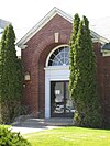 |
July 16, 2009 (#09000541) |
10831 North Thorp Highway 47°04′14″N 120°40′37″W / 47.070561°N 120.6769°W | Thorp | Rural Public Schools of Washington State MPS |
| 24 | Thorp Mill | 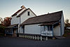 |
November 23, 1977 (#77001343) |
Thorp Highway off U.S. 10 47°04′27″N 120°41′01″W / 47.074265°N 120.683664°W | Thorp | |
| 25 | Washington State Normal School Building | 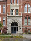 |
December 12, 1976 (#76001896) |
8th Avenue 47°00′01″N 120°32′27″W / 47.000278°N 120.540833°W | Ellensburg |
Former listings edit
| [3] | Name on the Register | Image | Date listed | Date removed | Location | City or town | Description |
|---|---|---|---|---|---|---|---|
| 1 | John W. Kinkade Farmstead | 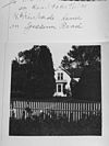 |
February 25, 1982 (#82004257) | February 5, 2001 | Off US 7B | Ellensburg vicinity | Listed in 1982. |
See also edit
References edit
- ^ The latitude and longitude information provided in this table was derived originally from the National Register Information System, which has been found to be fairly accurate for about 99% of listings. Some locations in this table may have been corrected to current GPS standards.
- ^ National Park Service, United States Department of the Interior, "National Register of Historic Places: Weekly List Actions", retrieved April 5, 2024.
- ^ a b Numbers represent an alphabetical ordering by significant words. Various colorings, defined here, differentiate National Historic Landmarks and historic districts from other NRHP buildings, structures, sites or objects.
- ^ "National Register Information System". National Register of Historic Places. National Park Service. April 24, 2008.
- ^ The eight-digit number below each date is the number assigned to each location in the National Register Information System database, which can be viewed by clicking the number.
- ^ "PCAD - Masonic Building, Lodge #2, Downtown, Ellensburg, WA".
- ^ Larry Nickel (July 1976). "National Register of Historic Places Inventory-Nomination: Downtown Ellensburg Historic District". National Park Service. Retrieved February 1, 2022. With accompanying 12 photos from 1976, the second being of the Masonic Temple.
External links edit
![]() Media related to National Register of Historic Places in Kittitas County, Washington at Wikimedia Commons
Media related to National Register of Historic Places in Kittitas County, Washington at Wikimedia Commons