
KNOWPIA
WELCOME TO KNOWPIA

National Register of Historic Places listings in Lauderdale County, Mississippi 
Summary
This is a list of the National Register of Historic Places listings in Lauderdale County, Mississippi.

This is intended to be a complete list of the properties and districts on the National Register of Historic Places in Lauderdale County, Mississippi, United States. Latitude and longitude coordinates are provided for many National Register properties and districts; these locations may be seen together in a map.[1]
There are 46 properties and districts listed on the National Register in the county. Another 7 properties were once listed but have been removed.[2]
This National Park Service list is complete through NPS recent listings posted April 12, 2024.[3]
Current listings edit
| [4] | Name on the Register | Image | Date listed[5] | Location | City or town | Description |
|---|---|---|---|---|---|---|
| 1 | Beth Israel Cemetery |  |
March 22, 1989 (#89000169) |
19th St. and 5th Ave. 32°22′38″N 88°40′57″W / 32.377222°N 88.6825°W | Meridian | A cemetery dating from 1870 |
| 2 | Cahn-Crawford House |  |
December 18, 1979 (#79003384) |
1200 22nd Ave. 32°22′07″N 88°42′01″W / 32.368611°N 88.700278°W | Meridian | |
| 3 | Carnegie Branch Library | December 18, 1979 (#79003385) |
2721 13th St. 32°22′10″N 88°42′23″W / 32.369444°N 88.706389°W | Meridian | ||
| 4 | Causeyville Historic District | 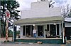 |
January 2, 1986 (#86000058) |
Meridian-Causeyville Rd. 32°15′30″N 88°33′46″W / 32.258333°N 88.562778°W | Causeyville | |
| 5 | Coosha | November 21, 1978 (#78001608) |
Address restricted[6] | Lizelia | ||
| 6 | Dabney-Green House |  |
December 18, 1979 (#79003386) |
1017 22nd Ave. 32°22′03″N 88°42′02″W / 32.367500°N 88.700556°W | Meridian | |
| 7 | Dement Printing Company |  |
December 18, 1979 (#79003387) |
2002 6th St. 32°21′55″N 88°41′57″W / 32.365278°N 88.699167°W | Meridian | |
| 8 | East End Historic District |  |
August 21, 1987 (#87000470) |
Roughly bounded by 18th St., 11th Ave., 14th St., 14th Ave., 5th St., and 17th Ave. 32°22′20″N 88°41′28″W / 32.372222°N 88.691111°W | Meridian | |
| 9 | Elson-Dudley House |  |
December 18, 1979 (#79003390) |
1101 29th Ave. 32°22′04″N 88°42′27″W / 32.367778°N 88.7075°W | Meridian | |
| 10 | First Presbyterian Church of Meridian |  |
December 18, 1979 (#79003391) |
911 23rd Ave. 32°21′59″N 88°42′06″W / 32.366389°N 88.701667°W | Meridian | |
| 11 | Grand Opera House |  |
December 27, 1972 (#72000696) |
2208 5th St. 32°22′21″N 88°42′02″W / 32.3725°N 88.700556°W | Meridian | |
| 12 | Highland Park | 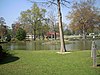 |
February 28, 1979 (#79001325) |
Roughly bounded by 15th and 19th Sts., 37th and 47th Aves. 32°22′28″N 88°43′04″W / 32.374444°N 88.717778°W | Meridian | |
| 13 | Highland Park Dentzel Carousel and Shelter Building |  |
February 27, 1987 (#87000863) |
Highland Park 32°22′34″N 88°43′05″W / 32.376111°N 88.718056°W | Meridian | |
| 14 | Highlands Historic District |  |
August 21, 1987 (#87000467) |
Roughly bounded by 15th St., 34th Ave., 5th St., 19th St., and 36th Ave. 32°22′29″N 88°42′41″W / 32.374722°N 88.711389°W | Meridian | |
| 15 | Lacy Homestead | July 19, 2007 (#07000747) |
Address restricted[6] | Toomsuba | ||
| 16 | Lamar Hotel | 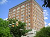 |
December 18, 1979 (#79003393) |
410 21st St. 32°21′52″N 88°41′54″W / 32.364444°N 88.698333°W | Meridian | |
| 17 | Alex Loeb Building | 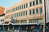 |
December 18, 1979 (#79003394) |
2115 5th St. 32°21′51″N 88°41′56″W / 32.364167°N 88.698889°W | Meridian | |
| 18 | Masonic Temple |  |
December 18, 1979 (#79003395) |
1220 26th Ave. 32°22′10″N 88°42′16″W / 32.369444°N 88.704444°W | Meridian | Sometime after its listing the building was demolished. |
| 19 | McLemore Cemetery | 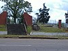 |
December 18, 1979 (#79003396) |
601 16th Ave. 32°22′03″N 88°41′41″W / 32.3675°N 88.694722°W | Meridian | |
| 20 | Meridian Downtown Historic District | 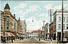 |
January 16, 2007 (#06001249) |
Roughly bounded by 26th Ave., 18th Ave., 6th St., and Front St. 32°21′50″N 88°41′59″W / 32.3639°N 88.6998°W | Meridian | |
| 21 | Meridian Museum of Art |  |
December 18, 1979 (#79003397) |
628 25th Ave. 32°21′49″N 88°42′12″W / 32.363611°N 88.703333°W | Meridian | Art museum for many years; formerly the Carnegie Library for whites in Meridian |
| 22 | Meridian Senior High School and Junior College |  |
May 29, 2014 (#14000275) |
2320 32nd St. 32°23′27″N 88°42′07″W / 32.390708°N 88.702026°W | Meridian | |
| 23 | Meridian Urban Center Historic District |  |
December 18, 1979 (#79003732) |
Roughly bounded by 21st and 25th Aves., 6th St., and the former Gulf, Mobile and Ohio railroad line 32°21′47″N 88°42′01″W / 32.363056°N 88.700278°W | Meridian | |
| 24 | Meridian Waterworks Pumping Station and Clear Water Basin | 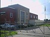 |
July 26, 1989 (#89000931) |
B St. and 17th Ave. 32°21′43″N 88°41′30″W / 32.361944°N 88.691667°W | Meridian | |
| 25 | Merrehope |  |
December 9, 1971 (#71000455) |
905 31st Ave. 32°22′01″N 88°43′35″W / 32.366944°N 88.726389°W | Meridian | |
| 26 | Merrehope Historic District |  |
September 19, 1988 (#88000973) |
Roughly bounded by 33rd Ave., 30th Ave., 14th St., 25th Ave., and 8th St. 32°22′05″N 88°42′26″W / 32.368056°N 88.707222°W | Meridian | |
| 27 | Mid-Town Historic District |  |
August 21, 1987 (#87000463) |
Roughly bounded by 23rd Ave., 15th St., 28th Ave., and 22nd St. 32°22′38″N 88°42′07″W / 32.377222°N 88.701944°W | Meridian | |
| 28 | Municipal Building |  |
December 18, 1979 (#79003399) |
601 24th Ave. 32°21′49″N 88°42′08″W / 32.363611°N 88.702222°W | Meridian | |
| 29 | Niolon Building | 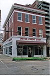 |
December 18, 1979 (#79003400) |
718 23rd Ave. 32°21′53″N 88°42′05″W / 32.364722°N 88.701389°W | Meridian | |
| 30 | Old Terminal Building, Hangar and Powerhouse at Key Field |  |
July 7, 2003 (#03000587) |
2525 U.S. Route 11, S. 32°20′14″N 88°44′33″W / 32.337222°N 88.7425°W | Meridian | |
| 31 | Pigford Building |  |
December 18, 1979 (#79003401) |
818 22nd Ave. 32°21′56″N 88°42′00″W / 32.365556°N 88.7°W | Meridian | |
| 32 | Poplar Springs Road Historic District | 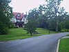 |
August 21, 1987 (#87000461) |
Roughly bounded by 29th St., 23rd Ave., 22nd St., and 29th Ave. 32°23′05″N 88°42′11″W / 32.384722°N 88.703056°W | Meridian | |
| 33 | Porter-Crawford House |  |
December 18, 1979 (#79003402) |
1208 22nd Ave. 32°22′09″N 88°42′01″W / 32.369167°N 88.700278°W | Meridian | |
| 34 | St. Patrick Catholic Church | 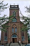 |
December 18, 1979 (#79003403) |
2614 Davis St. 32°21′48″N 88°42′17″W / 32.363333°N 88.704722°W | Meridian | |
| 35 | The Simmons & Wright Company | 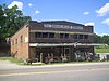 |
March 13, 2008 (#08000198) |
5493 U.S. Routes 11/80 32°25′28″N 88°26′20″W / 32.424444°N 88.438889°W | Kewanee | |
| 36 | Standard Drug Company | 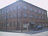 |
December 7, 1989 (#89002050) |
601 25th Ave. 32°21′46″N 88°42′12″W / 32.362778°N 88.703333°W | Meridian | |
| 37 | Stevenson Primary School |  |
December 18, 1979 (#79003405) |
1015 25th Ave. 32°22′01″N 88°42′14″W / 32.366944°N 88.703889°W | Meridian | |
| 38 | Stuckey's Bridge |  |
November 16, 1988 (#88002415) |
Spans the Chunky River on a county road 32°15′20″N 88°51′19″W / 32.255556°N 88.855278°W | Meridian | |
| 39 | Temple Theater |  |
December 18, 1979 (#79003407) |
2318 8th St. 32°21′54″N 88°42′09″W / 32.365°N 88.7025°W | Meridian | |
| 40 | Threefoot Building |  |
December 18, 1979 (#79003408) |
601 22nd Ave. 32°21′52″N 88°42′02″W / 32.364444°N 88.700556°W | Meridian | |
| 41 | Union Hotel |  |
December 18, 1979 (#79003409) |
2000 Front St. 32°21′50″N 88°41′50″W / 32.363889°N 88.697222°W | Meridian | |
| 42 | Union Station Historic District |  |
December 18, 1979 (#79003731) |
Roughly bounded by 18th and 19th Aves., 5th St., and the former Gulf, Mobile and Ohio railroad line 32°21′54″N 88°41′46″W / 32.365°N 88.696111°W | Meridian | |
| 43 | US Post Office and Courthouse | 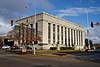 |
May 17, 1984 (#84002236) |
2100 9th St. 32°21′59″N 88°41′59″W / 32.366389°N 88.699722°W | Meridian | |
| 44 | US Sugar Crop Field Station |  |
January 11, 1991 (#90002124) |
Junction of Sonny Montgomery Industrial Parkway and Peavy Dr. 32°24′41″N 88°36′44″W / 32.411389°N 88.612222°W | Meridian | |
| 45 | Wechsler School |  |
July 15, 1991 (#91000880) |
1415 30th Ave. 32°22′17″N 88°42′33″W / 32.371389°N 88.709167°W | Meridian | First brick school building built in the state, in 1894, for black children in elementary grades |
| 46 | West End Historic District |  |
August 21, 1987 (#87000459) |
Roughly bounded by 7th St., 28th Ave., Shearer's Branch, and 5th St. 32°21′46″N 88°42′29″W / 32.362778°N 88.708056°W | Meridian |
Former listings edit
| [4] | Name on the Register | Image | Date listed | Date removed | Location | City or town | Description |
|---|---|---|---|---|---|---|---|
| 1 | Dial House | December 18, 1979 (#79003388) | January 28, 2016 | 1003 30th Ave. 32°22′00″N 88°42′32″W / 32.366667°N 88.708889°W | Meridian | Demolished in February 2005. | |
| 2 | Dixie Gas Station |  |
February 6, 1980 (#79003389) | October 1, 1987 | Meridian | Demolished in 1986.[7] | |
| 3 | Gulf, Mobile & Ohio Freight Depot | February 6, 1980 (#79003392) | November 8, 1996 | 20 22nd Ave. | Meridian | Destroyed by fire on June 10, 1985.[8][9] | |
| 4 | Meridian Baptist Seminary | January 8, 1979 (#79001326) | July 16, 2008 | 16th St. and 31st Ave. | Meridian | Destroyed by fire in 2007.[10] | |
| 5 | Meyer-Loeb Building | February 6, 1980 (#79003398) | October 1, 1987 | 2100 4th St. | Meridian | Demolished in 1980.[11] | |
| 6 | Scottish Rite Cathedral | December 18, 1979 (#79003404) | May 15, 1987 | 1101 23rd Ave. | Meridian | Destroyed by fire on March 20, 1985.[12][13] | |
| 7 | Suttle Building | December 18, 1979 (#79003406) | December 15, 1999 | 801 22nd Ave. | Meridian | Demolished in February 1999.[14] |
See also edit
Wikimedia Commons has media related to National Register of Historic Places in Lauderdale County, Mississippi.
References edit
- ^ The latitude and longitude information provided in this table was derived originally from the National Register Information System, which has been found to be fairly accurate for about 99% of listings. Some locations in this table may have been corrected to current GPS standards.
- ^ "National Register Information System". National Register of Historic Places. National Park Service. March 13, 2009.
- ^ National Park Service, United States Department of the Interior, "National Register of Historic Places: Weekly List Actions", retrieved April 12, 2024.
- ^ a b Numbers represent an alphabetical ordering by significant words. Various colorings, defined here, differentiate National Historic Landmarks and historic districts from other NRHP buildings, structures, sites or objects.
- ^ The eight-digit number below each date is the number assigned to each location in the National Register Information System database, which can be viewed by clicking the number.
- ^ a b Federal and state laws and practices restrict general public access to information regarding the specific location of this resource. In some cases, this is to protect archeological sites from vandalism, while in other cases it is restricted at the request of the owner. See: Knoerl, John; Miller, Diane; Shrimpton, Rebecca H. (1990), Guidelines for Restricting Information about Historic and Prehistoric Resources, National Register Bulletin, National Park Service, U.S. Department of the Interior, OCLC 20706997.
- ^ National Register of Historic Places: Nomination form for Dixie Gas Station (#79003389). National Park Service.
- ^ National Register of Historic Places: Nomination form for Gulf, Mobile & Ohio Freight Depot (#79003392). National Park Service.
- ^ "Historic depot damaged by fire". Sun Herald. June 12, 1995. p. C2. Retrieved July 31, 2022 – via Newspapers.com.
- ^ "Cause of Seminary Fire "Undetermined"". Meridian, Mississippi: WTOK-TV.com. October 24, 2007. Archived from the original on July 18, 2011. Retrieved 2010-07-18.
- ^ National Register of Historic Places: Nomination form for Meyer-Loeb Building (#79003398). National Park Service.
- ^ "Letter from Kenneth H. P'Pool, Deputy State Historic Preservation Officer, to Carol D. Shull, Chief of Registration for the National Register". May 11, 1987.
The properties listed below no longer exist and have been recommended by the Mississippi State Professional Review Board for delisting from the National Register of Historic Places: [...] Scottish Rite Cathedral. 1101 23rd Avenue, Meridian, Lauderdale County. Listed 12/18/1979. Destroyed by fire 3/20/1985
{{cite journal}}: Cite journal requires|journal=(help) Attached is the original National Register of Historic Places nomination form for Scottish Rite Cathedral (#79003404), including one image (January 1979). Jody Cook (February 1979). National Park Service. - ^ "Fire destroys Scottish Rite Temple". The Clarion-Ledger. March 21, 1985. p. 3B. Retrieved July 31, 2022 – via Newspapers.com.
- ^ National Register of Historic Places: Nomination form for Suttle Building (#79003406). National Park Service.