
KNOWPIA
WELCOME TO KNOWPIA

National Register of Historic Places listings in Laurens County, Georgia 
Summary
This is a list of properties and districts in Laurens County, Georgia that are listed on the National Register of Historic Places (NRHP).

This National Park Service list is complete through NPS recent listings posted April 19, 2024.[1]
Current listings edit
| [2] | Name on the Register | Image | Date listed[3] | Location | City or town | Description |
|---|---|---|---|---|---|---|
| 1 | Carnegie Library | 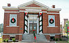 |
May 30, 1975 (#75000599) |
Jct. of Bellevue/Jackson and Academy Sts. (311 Academy Ave.) 32°32′19″N 82°54′30″W / 32.53864°N 82.90829°W | Dublin | NRHP form incorrectly gives the location as 32°31'20"N, 82°54'28"W. It is a contributing property to the Dublin Commercial Historic District. |
| 2 | Dublin Commercial Historic District |  |
May 22, 2002 (#02000540) |
Roughly centered on Jackson Ave. and Lawrence St. 32°32′20″N 82°54′19″W / 32.538889°N 82.905278°W | Dublin | |
| 3 | Dublin Veterans Administration Hospital |  |
December 10, 2018 (#100003205) |
1826 Veterans Blvd. 32°32′14″N 82°56′34″W / 32.53711°N 82.94291°W | Dublin | |
| 4 | First African Baptist Church |  |
August 16, 2019 (#100004299) |
405 Telfair St. 32°32′08″N 82°54′25″W / 32.53542°N 82.90700°W | Dublin | |
| 5 | Fish Trap Cut | October 1, 1974 (#74000691) |
Address Restricted 32°28′15″N 82°51′28″W / 32.47072°N 82.85764°W | Dublin | Fish Cut Mounds Fish Trap Cut | |
| 6 | Sanders Hill | May 28, 1975 (#75000600) |
S of Montrose off I-16/GA 404. 1.5 miles SW of Montrose, 5.5 miles W of Dudley. One acre surrounded by dirt road to the west and a fence around the rest (1975 NRHP form). 32°32′20″N 83°09′55″W / 32.538889°N 83.165278°W | Montrose | ||
| 7 | Stubbs Park-Stonewall Street Historic District |  |
November 7, 2002 (#02001293) |
Roughly bounded by W. Moore St., Roosevelt St., Bellevue Ave., Marion St., Academy Ave., Lancaster and Thompson Sts. 32°32′07″N 82°54′59″W / 32.5352°N 82.9165°W | Dublin | |
| 8 | Emery Thomas Auditorium | May 10, 2022 (#100007698) |
100 Riverview Dr. 32°31′28″N 82°53′25″W / 32.5245°N 82.8904°W | Dublin | ||
| 9 | United States Post Office and Court House |  |
June 15, 2018 (#100002569) |
100 N Franklin St. 32°32′25″N 82°54′12″W / 32.5404°N 82.9032°W | Dublin | Now the Federal Building and US Courthouse |
References edit
Wikimedia Commons has media related to National Register of Historic Places in Laurens County, Georgia.
- ^ National Park Service, United States Department of the Interior, "National Register of Historic Places: Weekly List Actions", retrieved April 19, 2024.
- ^ Numbers represent an alphabetical ordering by significant words. Various colorings, defined here, differentiate National Historic Landmarks and historic districts from other NRHP buildings, structures, sites or objects.
- ^ The eight-digit number below each date is the number assigned to each location in the National Register Information System database, which can be viewed by clicking the number.