
KNOWPIA
WELCOME TO KNOWPIA

National Register of Historic Places listings in Linn County, Oregon 
Summary
This list presents the full set of buildings, structures, objects, sites, or districts designated on the National Register of Historic Places in Linn County, Oregon, and offers brief descriptive information about each of them. The National Register recognizes places of national, state, or local historic significance across the United States.[1] Out of over 90,000 National Register sites nationwide,[2] Oregon is home to over 2,000,[3] and 75 of those are found partially or wholly in Linn County.

This National Park Service list is complete through NPS recent listings posted April 12, 2024.[4]
Current listings edit
| [5] | Name on the Register | Image | Date listed[6] | Location | City or town | Description |
|---|---|---|---|---|---|---|
| 1 | David and Maggie Aegerter Barn |  |
July 15, 1999 (#99000780) |
41915 Ridge Dr. 44°44′54″N 122°44′37″W / 44.748333°N 122.743611°W | Scio | |
| 2 | Albany Custom Mill |  |
February 12, 1980 (#80003338) |
213 Water St. 44°38′18″N 123°06′23″W / 44.638333°N 123.106389°W | Albany | |
| 3 | Albany Downtown Commercial Historic District |  |
December 9, 1982 (#82001509) |
Roughly bounded by the Willamette River and Montgomery, Washington, and 5th Sts. 44°38′12″N 123°06′22″W / 44.636667°N 123.106111°W | Albany | |
| 4 | Albany Hebrew Cemetery |  |
May 18, 2015 (#15000240) |
3165 Salem Avenue SE 44°38′33″N 123°04′06″W / 44.642506°N 123.068350°W | Albany | |
| 5 | Albany Monteith Historic District |  |
February 29, 1980 (#80003341) |
Roughly bounded by 2nd, Lyon, 12th and Elm Sts.; also Elm St. southwest to Calapooia and 19th Ave., SW. to 11th and 12th Aves., SW. 44°37′55″N 123°06′31″W / 44.631944°N 123.108611°W | Albany | Second set of boundaries represents a boundary increase of November 13, 2008 |
| 6 | Albany Municipal Airport | 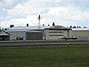 |
June 3, 1998 (#98000630) |
3510 Knox Butte Rd. 44°38′24″N 123°03′29″W / 44.64°N 123.058056°W | Albany | |
| 7 | Jerry Andrus House |  |
October 25, 2011 (#11000769) |
1638 1st Ave. E. 44°38′22″N 123°05′06″W / 44.639444°N 123.085°W | Albany | |
| 8 | Steven and Elizabeth Archibald Farmstead |  |
September 22, 2004 (#04001068) |
31888 Wirth Rd. 44°30′47″N 123°04′46″W / 44.513056°N 123.079444°W | Tangent | |
| 9 | Granville H. Baber House |  |
October 29, 1975 (#75001588) |
Northeast of Albany off U.S. 99 44°40′43″N 123°01′18″W / 44.678611°N 123.021667°W | Albany | |
| 10 | Hiram Baker House |  |
June 3, 1996 (#96000621) |
515 E. Grant St. 44°32′18″N 122°53′53″W / 44.538333°N 122.898056°W | Lebanon | |
| 11 | Dr. J. C. Booth House |  |
April 1, 1980 (#80003344) |
486 Park St. 44°32′29″N 122°54′17″W / 44.541389°N 122.904722°W | Lebanon | |
| 12 | Boston Flour Mill | 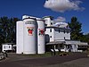 |
August 21, 1979 (#79002117) |
E of Shedd on Boston Mill Rd. 44°27′41″N 123°04′47″W / 44.461389°N 123.079722°W | Shedd | |
| 13 | Hugh Leeper Brown Barn |  |
November 15, 1979 (#79002112) |
SE of Brownsville on OR 228 44°22′52″N 122°57′28″W / 44.381111°N 122.957778°W | Brownsville | |
| 14 | John and Amelia Brown Farmhouse | 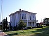 |
November 22, 1978 (#78003408) |
SE of Brownsville on OR 228 44°22′56″N 122°57′53″W / 44.382222°N 122.964722°W | Brownsville | |
| 15 | Cascadia Cave |  |
October 25, 1990 (#90001589) |
Address restricted[7] | Cascadia | |
| 16 | George Earle Chamberlain House |  |
February 22, 1980 (#80003339) |
208 SE 7th Ave. 44°37′58″N 123°06′08″W / 44.632656°N 123.102271°W | Albany | |
| 17 | Matthew C. Chambers Barn |  |
September 27, 1996 (#96001044) |
.4 mi. N of jct. of Knox Butte Rd. and Scravel Hill Rd. 44°39′11″N 123°01′23″W / 44.653056°N 123.023056°W | Albany | |
| 18 | William Cochran Barn |  |
July 8, 1999 (#99000782) |
28485 Brownsville Rd. 44°25′18″N 122°59′13″W / 44.421667°N 122.986944°W | Brownsville | |
| 19 | George C. Cooley House |  |
May 9, 1983 (#83002160) |
220 Blakely Ave. 44°23′06″N 122°58′53″W / 44.385°N 122.981389°W | Brownsville | |
| 20 | Crabtree Creek-Hoffman Covered Bridge |  |
February 17, 1987 (#87000017) |
Hungry Hill Dr., 1.8 mi. N of Crabtree 44°39′12″N 122°53′25″W / 44.653349°N 122.890351°W | Crabtree | |
| 21 | Louis A. Crandall House |  |
October 25, 1990 (#90001588) |
959 Main St. 44°32′13″N 122°54′20″W / 44.536944°N 122.905556°W | Lebanon | |
| 22 | Crawfordsville Bridge |  |
November 29, 1979 (#79002115) |
SR 228 44°21′28″N 122°51′32″W / 44.357778°N 122.858889°W | Crawfordsville | |
| 23 | Henry and Mary Cyrus Barn | 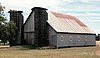 |
November 9, 2015 (#15000778) |
37964 Balm Dr. 44°37′27″N 122°53′06″W / 44.624133°N 122.885029°W | Lebanon | |
| 24 | Alfred Dawson House |  |
February 12, 1980 (#80003340) |
731 SW Broadalbin St. 44°38′28″N 123°06′18″W / 44.641111°N 123.105°W | Albany | |
| 25 | Elkins Flour Mill |  |
June 9, 1995 (#95000689) |
Bounded by US 20, Industrial Way, the Santiam-Albany Canal and the Callaghan RR tracks 44°32′52″N 122°54′19″W / 44.547778°N 122.905278°W | Lebanon | |
| 26 | Hugh Fields House |  |
July 19, 1989 (#89000853) |
36176 OR 228 44°22′51″N 122°56′29″W / 44.380833°N 122.941389°W | Brownsville | |
| 27 | First Baptist Church of Brownsville |  |
June 19, 1991 (#91000807) |
515 N. Main St. 44°23′44″N 122°59′01″W / 44.395556°N 122.983611°W | Brownsville | |
| 28 | First Evangelical Church of Albany |  |
August 1, 1984 (#84003030) |
1120 SW. 12th Ave. 44°37′38″N 123°06′52″W / 44.627222°N 123.114444°W | Albany | |
| 29 | Fish Lake Guard Station |  |
June 27, 2014 (#14000381) |
57600 McKenzie Highway 44°24′12″N 122°00′22″W / 44.403314°N 122.006078°W | McKenzie Bridge vicinity | |
| 30 | Flinn Block | 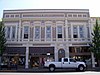 |
March 2, 1979 (#79002109) |
222 SW. 1st Ave. 44°38′13″N 123°06′21″W / 44.636944°N 123.105833°W | Albany | |
| 31 | Hackleman Historic District |  |
March 15, 1982 (#82003735) |
Roughly bounded by Pacific Boulevard and Lyons, 2nd and Madison Sts. 44°38′06″N 123°05′54″W / 44.635°N 123.098333°W | Albany | |
| 32 | Hannah Bridge |  |
November 29, 1979 (#79002116) |
Burmester Creek Rd. 44°42′44″N 122°43′04″W / 44.712222°N 122.717778°W | Scio | |
| 33 | Harrisburg Odd Fellows Hall | 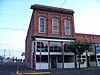 |
October 15, 1992 (#92001382) |
190 Smith St. 44°16′20″N 123°10′12″W / 44.272222°N 123.17°W | Harrisburg | |
| 34 | George Hochstedler House |  |
October 10, 1980 (#80004549) |
237 SE 6th Ave. 44°38′02″N 123°06′02″W / 44.633889°N 123.100556°W | Albany | |
| 35 | C. J. Howe Building |  |
April 1, 1980 (#80003343) |
104 Spaulding Ave. 44°23′38″N 122°59′00″W / 44.393889°N 122.983333°W | Brownsville | |
| 36 | Independence Prairie Ranger Station |  |
March 29, 1983 (#83002161) |
Willamette National Forest 44°37′02″N 121°56′22″W / 44.617222°N 121.939444°W | Marion Forks | |
| 37 | Larwood Bridge |  |
November 29, 1979 (#79003733) |
E of Crabtree 44°37′48″N 122°44′21″W / 44.63°N 122.739167°W | Crabtree | |
| 38 | Lebanon Pioneer Cemetery |  |
March 5, 1998 (#98000208) |
200 Dodge St. 44°32′40″N 122°54′14″W / 44.544444°N 122.903889°W | Lebanon | |
| 39 | Lebanon Southern Pacific Railroad Depot |  |
June 13, 1997 (#97000584) |
735 Third St. 44°32′20″N 122°54′36″W / 44.538833°N 122.910083°W | Lebanon | |
| 40 | Hector and Margaret Macpherson Barn |  |
July 8, 1999 (#99000781) |
29780 Church Dr. 44°30′42″N 123°11′32″W / 44.511667°N 123.192222°W | Albany | |
| 41 | Marion Forks Guard Station |  |
March 6, 1991 (#91000167) |
OR 22, Willamette NF 44°36′51″N 121°56′56″W / 44.614167°N 121.948889°W | Marion Forks | |
| 42 | Joseph and Barbara Maurer House |  |
September 27, 1996 (#96001045) |
35168 Tennessee Rd. 44°36′14″N 122°55′21″W / 44.603889°N 122.9225°W | Lebanon | |
| 43 | McKenzie Highway Historic District |  |
February 7, 2011 (#10001215) |
OR 242 44°14′55″N 121°50′18″W / 44.248611°N 121.838333°W | Sisters to Belknap Springs | Extends into Deschutes and Lane counties. |
| 44 | Methodist Episcopal Church South |  |
November 16, 1979 (#79002110) |
238 E. 3rd St 44°38′10″N 123°06′04″W / 44.636111°N 123.101111°W | Albany | |
| 45 | Gottlieb and Della Milde Barn |  |
July 15, 1999 (#99000785) |
36898 Northern Dr. 44°22′34″N 122°54′55″W / 44.376111°N 122.915278°W | Brownsville | |
| 46 | Mill City Southern Pacific Rail Road (SPRR) Bridge |  |
June 22, 2021 (#100006686) |
Spanning the North Santiam River 44°45′19″N 122°28′40″W / 44.755268°N 122.477772°W | Mill City | |
| 47 | Thomas and Walter Monteith House | 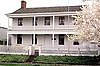 |
May 21, 1975 (#75001586) |
518 W. 2nd Ave. 44°38′10″N 123°06′33″W / 44.636111°N 123.109167°W | Albany | |
| 48 | John and Mary Moore House |  |
October 1, 2001 (#01001066) |
320 Kirk Ave. 44°23′33″N 122°58′49″W / 44.3925°N 122.980278°W | Brownsville | |
| 49 | John M. Moyer House |  |
January 21, 1974 (#74001693) |
204 Main St. 44°23′35″N 122°59′03″W / 44.393056°N 122.984167°W | Brownsville | |
| 50 | Mt. Pleasant Presbyterian Church |  |
January 24, 1974 (#74001694) |
S of Stayton on Kingston-Jordan Rd. 44°45′31″N 122°44′38″W / 44.758611°N 122.743889°W | Stayton | |
| 51 | Oregon Pacific Railroad Linear Historic District |  |
October 29, 1999 (#99001285) |
Roughly a 20-mile linear section of the old railroad grade between Idanha and the Cascade Range summit (See also Marion and Jefferson counties.) 44°27′10″N 121°53′57″W / 44.452778°N 121.899167°W | Idanha to the Cascade Range summit via Santiam Junction | Beginning in 1872, the colorful Thomas Egenton Hogg set out to build a transcontinental railroad terminating in the Oregon Coast. By the time of his venture's final bankruptcy in 1894, completed track reached only from Yaquina Bay to Idanha in the Cascade foothills, with grade work under way east of Idanha to the summit. The historic district protects the remaining signs of the grade work east of Idanha, as well as the sites of two construction camps. Abandoned part way through construction, these remnants provide a unique window onto construction methods and living conditions in 19th century railroad camps.[8] |
| 52 | Moses Parker House |  |
August 25, 1980 (#80003342) |
638 SE 5th St. 44°38′09″N 123°05′45″W / 44.635833°N 123.095833°W | Albany | |
| 53 | E. C. Peery Building |  |
May 29, 1998 (#98000604) |
38731 N. Main St. 44°42′18″N 122°50′50″W / 44.705°N 122.847222°W | Scio | |
| 54 | Porter-Brasfield House |  |
November 25, 1980 (#80003345) |
31838 Fayetteville Dr. 44°27′41″N 123°06′36″W / 44.461389°N 123.11°W | Shedd | |
| 55 | John and Lottie Ralston Cottage |  |
March 5, 1998 (#98000203) |
481 Main St. 44°32′29″N 122°54′20″W / 44.541389°N 122.905556°W | Lebanon | |
| 56 | John Ralston House |  |
December 9, 1981 (#81000501) |
632 SE Baker St. 44°37′59″N 123°06′06″W / 44.633056°N 123.101667°W | Albany | |
| 57 | Riverside Community Hall |  |
February 14, 2023 (#100008640) |
35293 Riverside Dr. SW 44°36′00″N 123°09′38″W / 44.6001°N 123.1605°W | Albany | |
| 58 | Rock Hill School |  |
June 4, 1992 (#92000661) |
Rock Hill Dr., 2.2 mi. E of Sand Ridge Rd. 44°28′59″N 122°56′50″W / 44.483056°N 122.947222°W | Lebanon | |
| 59 | Ross-Averill House |  |
February 20, 1991 (#91000061) |
420 Averill St. 44°23′41″N 122°59′04″W / 44.394722°N 122.984444°W | Brownsville | |
| 60 | Michael and Mary Ryan Barn |  |
July 15, 1999 (#99000784) |
40363 Huntley Rd. 44°45′07″N 122°44′26″W / 44.751944°N 122.740556°W | Scio | |
| 61 | Santiam Pass Ski Lodge |  |
October 18, 2018 (#100003033) |
64405 U.S. 20, Willamette National Forest 44°25′19″N 121°51′55″W / 44.422078°N 121.865299°W | Sisters vicinity | |
| 62 | Santiam Wagon Road |  |
September 23, 2010 (#10000795) |
Willamette National Forest and Deschutes National Forest 44°25′29″N 121°50′44″W / 44.42471°N 121.84559°W | Cascadia and Sisters vicinity | Extends into Deschutes County.[9][10] |
| 63 | Short Bridge |  |
November 29, 1979 (#79002113) |
High Deck Rd. 44°23′30″N 122°30′31″W / 44.391667°N 122.508611°W | Cascadia | |
| 64 | James Alexander and Elmarion Smith Barn and Lame-Smith House | 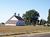 |
July 15, 1999 (#99000783) |
28020 Powerline Rd. 44°24′18″N 123°07′06″W / 44.405°N 123.118333°W | Halsey | |
| 65 | Starr and Blakely Drug Store | 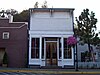 |
October 29, 1982 (#82001510) |
421 N. Main St. 44°23′40″N 122°59′01″W / 44.394444°N 122.983611°W | Brownsville | |
| 66 | Gus and Emma Stellmacher Farmstead | 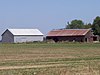 |
August 28, 1998 (#98001123) |
32404 Tangent Loop 44°31′29″N 123°05′36″W / 44.524722°N 123.093333°W | Tangent | |
| 67 | Thomas Creek-Gilkey Covered Bridge |  |
February 19, 1987 (#87000016) |
Goar Rd., 3 mi. N of Crabtree 44°41′17″N 122°54′08″W / 44.688056°N 122.902222°W | Crabtree | |
| 68 | Thomas Creek-Shimanek Covered Bridge |  |
February 19, 1987 (#87000013) |
Richardson Gap Rd., 2 mi. E of Scio 44°42′57″N 122°48′16″W / 44.715701°N 122.80441°W | Scio | |
| 69 | United Presbyterian Church and Rectory |  |
April 18, 1979 (#79002111) |
510 SW 5th Ave. 44°38′05″N 123°06′27″W / 44.634722°N 123.1075°W | Albany | |
| 70 | United Presbyterian Church of Shedd |  |
March 5, 1998 (#98000209) |
30045 OR 99 E 44°27′38″N 123°06′31″W / 44.460556°N 123.108611°W | Shedd | |
| 71 | Joseph Wesely House and Barn |  |
October 23, 1986 (#86002903) |
38791 Highway 226 44°41′51″N 122°50′57″W / 44.697410°N 122.849154°W | Scio | |
| 72 | Wigle Cemetery |  |
September 22, 2004 (#04001067) |
Belts Dr. 44°18′17″N 123°01′00″W / 44.304722°N 123.016667°W | Harrisburg | |
| 73 | Abraham and Mary Wigle House |  |
May 1, 2003 (#03000345) |
34050 Belts Dr. 44°18′05″N 123°01′26″W / 44.301389°N 123.023889°W | Harrisburg | |
| 74 | Jacob and Maranda K. Wigle Farmstead |  |
March 5, 1992 (#92000131) |
1119 Kirk Ave. 44°23′35″N 122°57′59″W / 44.393056°N 122.966389°W | Brownsville | |
| 75 | Z.C.B.J. Tolstoj Lodge No. 224 |  |
September 14, 1995 (#95001098) |
37091 Richardson Gap Rd. 44°39′37″N 122°48′10″W / 44.660278°N 122.802778°W | Scio |
Former listings edit
| [5] | Name on the Register | Image | Date listed | Date removed | Location | City or town | Description |
|---|---|---|---|---|---|---|---|
| 1 | Angell–Brewster House | 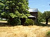 |
October 8, 1992 (#92001330) | April 20, 2011 | 34191 Brewster Rd. 44°34′46″N 122°52′12″W / 44.5794°N 122.87°W | Lebanon vicinity | Demolished in 2010. |
| 2 | St. Mary's Roman Catholic Church | June 5, 1975 (#75001587) | April 16, 1990 | 822 S. Ellsworth St. | Albany vicinity | Destroyed by arson fire October 29, 1989.[11][12][13] | |
| 3 | Weddle Bridge |  |
November 29, 1979 (#79002114) | January 11, 1989 | NW of Crabtree | Crabtree vicinity | Relocated in 1987. |
See also edit
- National Register of Historic Places listings in Oregon
- Listings in neighboring counties: Benton, Deschutes, Jefferson, Lane, Marion, Polk
- Historic preservation
- History of Oregon
- Lists of Oregon-related topics
References edit
- ^ Andrus, Patrick W.; Shrimpton, Rebecca H.; et al. (2002), How to Apply the National Register Criteria for Evaluation, National Register Bulletin, National Park Service, U.S. Department of the Interior, OCLC 39493977, archived from the original on April 6, 2014, retrieved June 20, 2014.
- ^ National Park Service, National Register of Historic Places Program: Research, archived from the original on February 1, 2015, retrieved January 28, 2015.
- ^ Oregon Parks and Recreation Department, Oregon Historic Sites Database, retrieved August 6, 2015. Note that a simple count of National Register records in this database returns a slightly higher total than actual listings, due to duplicate records. A close reading of detailed query results is necessary to arrive at the precise count.
- ^ National Park Service, United States Department of the Interior, "National Register of Historic Places: Weekly List Actions", retrieved April 12, 2024.
- ^ a b Numbers represent an alphabetical ordering by significant words. Various colorings, defined here, differentiate National Historic Landmarks and historic districts from other NRHP buildings, structures, sites or objects.
- ^ The eight-digit number below each date is the number assigned to each location in the National Register Information System database, which can be viewed by clicking the number.
- ^ Federal and state laws and practices restrict general public access to information regarding the specific location of this resource. In some cases, this is to protect archeological sites from vandalism, while in other cases it is restricted at the request of the owner. See: Knoerl, John; Miller, Diane; Shrimpton, Rebecca H. (1990), Guidelines for Restricting Information about Historic and Prehistoric Resources, National Register Bulletin, National Park Service, U.S. Department of the Interior, OCLC 20706997.
- ^ Tonsfeldt, Ward; Trussel, Tim; Boyer, William (February 12, 1998), National Register of Historic Places Registration Form: Oregon Pacific Railroad Historic District (PDF), retrieved February 14, 2013.
- ^ National Park Service (2010-10-01). "Weekly List of Actions Taken on Properties: 9/20/10 through 9/24/10". Retrieved 2010-10-01.
- ^ State Advisory Committee on Historic Preservation (2009-10-22). "Draft Meeting Minutes" (PDF). Retrieved 2010-10-01.[permanent dead link]
- ^ "Fire levels landmark in Albany". Statesman Journal. October 30, 1989. p. 1. Retrieved August 18, 2022 – via Newspapers.com.
- ^ "Fire destroys Albany church". Corvallis Gazette-Times. October 30, 1989. p. 1. Retrieved August 18, 2022 – via Newspapers.com.
- ^ Corvallis Gazette Times
External links edit
- Oregon Parks and Recreation Department, National Register Program
- National Park Service, National Register of Historic Places site
 Media related to National Register of Historic Places in Linn County, Oregon at Wikimedia Commons