
KNOWPIA
WELCOME TO KNOWPIA

National Register of Historic Places listings in Lynchburg, Virginia 
Summary
This is a list of the National Register of Historic Places listings in Lynchburg, Virginia.

This is intended to be a complete list of the properties and districts on the National Register of Historic Places in the independent city of Lynchburg, Virginia, United States. The locations of National Register properties and districts for which the latitude and longitude coordinates are included below, may be seen in an online map.[1]
There are 55 properties and districts listed on the National Register in the city, including 1 National Historic Landmark. Another property was once listed but has been removed.
This National Park Service list is complete through NPS recent listings posted April 12, 2024.[2]
Current listings edit
| [3] | Name on the Register | Image | Date listed[4] | Location | Description |
|---|---|---|---|---|---|
| 1 | Academy of Music |  |
June 11, 1969 (#69000340) |
522-526 Main St. 37°25′03″N 79°08′40″W / 37.4175°N 79.1444°W |
|
| 2 | Allied Arts Building |  |
December 19, 1985 (#85003203) |
725 Church St. 37°24′55″N 79°08′39″W / 37.4153°N 79.1442°W |
|
| 3 | Armstrong Elementary School |  |
August 22, 2012 (#12000542) |
1721 Monsview Pl. 37°25′46″N 79°09′36″W / 37.4294°N 79.1600°W |
|
| 4 | Aviary |  |
July 30, 1980 (#80004309) |
402 Grove St. 37°24′09″N 79°09′45″W / 37.4024°N 79.1625°W |
|
| 5 | Bragassa Toy Store |  |
January 11, 1991 (#90002136) |
323-325 12th St. 37°24′41″N 79°08′31″W / 37.4115°N 79.1419°W |
|
| 6 | Carnegie Hall |  |
August 17, 2020 (#100005441) |
1501 Lakeside Dr. 37°24′03″N 79°10′59″W / 37.4007°N 79.1831°W |
|
| 7 | Centerview | 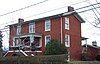 |
December 1, 2000 (#00001435) |
1900 Memorial Ave. 37°24′31″N 79°09′42″W / 37.4086°N 79.1617°W |
|
| 8 | Court House Hill-Downtown Historic District |  |
August 16, 2001 (#01000853) |
Church, Clay, Court, and Main Sts., and roughly bounded by 5th through 13th Sts.; also roughly along Madison St., Harrison St., 7th St., 6th St.; also the 300 and 400 blocks of 12th, the 1200 block of Church, the 1000 block of Main, 1001 Commerce St., and 1300 Court Sts. 37°24′51″N 79°08′37″W / 37.4141°N 79.1436°W |
Second and third sets of boundaries represent boundary increases of November 22, 2002 and May 16, 2016 |
| 9 | Court Street Baptist Church |  |
July 8, 1982 (#82004569) |
6th and Court Sts. 37°24′58″N 79°08′48″W / 37.4161°N 79.1467°W |
|
| 10 | Daniel's Hill Historic District |  |
February 24, 1983 (#83003289) |
Cabell, Norwood, Hancock, and Stonewall from 6th to H St. 37°25′30″N 79°08′53″W / 37.4250°N 79.1481°W |
|
| 11 | DeWitt-Wharton Manufacturing Company | February 18, 2021 (#100006156) |
1701 12th St. 37°24′17″N 79°09′14″W / 37.4047°N 79.1540°W |
||
| 12 | Diamond Hill Baptist Church |  |
February 22, 2011 (#11000026) |
1415 Grace St. 37°24′27″N 79°08′38″W / 37.4075°N 79.1439°W |
|
| 13 | Diamond Hill Historic District |  |
October 1, 1979 (#79003283) |
Roughly bounded by Dunbar Dr. and Main, Jackson, and Arch Sts.; also Grace St. 37°24′32″N 79°08′29″W / 37.4089°N 79.1414°W |
Grace St. represents a boundary increase of April 14, 1983 |
| 14 | Doyle Florist Inc.-H.R. Schenkel Inc. Greenhouse Range | 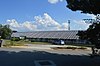 |
November 19, 2014 (#14000946) |
1339 Englewood St. 37°23′28″N 79°10′02″W / 37.3911°N 79.1672°W |
|
| 15 | Federal Hill Historic District |  |
September 17, 1980 (#80004310) |
Roughly bounded by 8th, 12th, Harrison, and Polk Sts. 37°24′39″N 79°08′51″W / 37.4108°N 79.1475°W |
|
| 16 | Fifth Street Historic District |  |
February 8, 2012 (#12000019) |
5th, 6th, Court, Clay, Madison, Harrison, Federal, Jackson, Polk, and Monroe Sts. 37°24′56″N 79°09′00″W / 37.4156°N 79.1500°W |
|
| 17 | First Baptist Church |  |
September 9, 1982 (#82004570) |
1100 Court St. 37°24′43″N 79°08′32″W / 37.4119°N 79.1422°W |
|
| 18 | Fort Early and Jubal Early Monument |  |
January 24, 2002 (#01001517) |
3511 Memorial Ave. 37°23′23″N 79°10′24″W / 37.3897°N 79.1733°W |
|
| 19 | Garland Hill Historic District |  |
September 7, 1972 (#72001507) |
Bounded roughly by 5th St., Federal Ave., and the Norfolk Southern railroad tracks 37°25′03″N 79°09′03″W / 37.4175°N 79.1508°W |
|
| 20 | Carter Glass House |  |
December 8, 1976 (#76002183) |
605 Clay St. 37°24′56″N 79°08′50″W / 37.4156°N 79.1472°W |
|
| 21 | Hopwood Hall |  |
August 28, 2017 (#100001513) |
1501 Lakeside Dr. 37°23′53″N 79°10′57″W / 37.3981°N 79.1825°W |
Academic building at Lynchburg College |
| 22 | Dr. Robert Walter Johnson House and Tennis Court |  |
January 24, 2002 (#01001519) |
1422 Pierce St. 37°24′11″N 79°09′02″W / 37.403056°N 79.150556°W |
|
| 23 | Jones Memorial Library |  |
October 30, 1980 (#80004311) |
434 Rivermont Ave. 37°25′20″N 79°08′59″W / 37.422222°N 79.149722°W |
|
| 24 | Kemper Street Industrial Historic District |  |
November 14, 2008 (#08001054) |
1300-1500 (odd) Kemper St., 1200-1300 (even) Campbell Ave. 37°24′06″N 79°09′20″W / 37.401667°N 79.155556°W |
|
| 25 | Kentucky Hotel |  |
December 11, 1986 (#86003468) |
900 5th St. 37°24′52″N 79°09′06″W / 37.414444°N 79.151667°W |
|
| 26 | Locust Grove |  |
December 17, 1992 (#92001704) |
Marvin Pl. 37°26′27″N 79°14′58″W / 37.440833°N 79.249444°W |
|
| 27 | Lower Basin Historic District |  |
April 24, 1987 (#87000601) |
700-1300 blocks of Jefferson St., 600-1300 blocks of Commerce St., and 1200-1300 blocks of Main St.; also 1307 Main St. and 103-109 6th St.; also generally bounded by Concord Tpk., CSX RR tracks, East Lynch, Main, and Washington Sts. 37°24′52″N 79°08′21″W / 37.414444°N 79.139167°W |
Additional sets of boundaries represent boundary increases of June 6, 2002 and July 18, 2023 |
| 28 | Lynch's Brickyard House |  |
March 13, 2002 (#02000180) |
700 Jackson St. 37°24′46″N 79°08′59″W / 37.412778°N 79.149861°W |
|
| 29 | Lynchburg Courthouse |  |
May 19, 1972 (#72001508) |
9th St. between Court and Church Sts. 37°24′49″N 79°08′40″W / 37.413611°N 79.144444°W |
|
| 30 | Lynchburg Hosiery Mill No. 1 |  |
February 21, 2017 (#100000677) |
2734 Fort Ave. 37°23′54″N 79°09′46″W / 37.398333°N 79.162778°W |
|
| 31 | Lynchburg Hospital |  |
December 9, 1999 (#99001506) |
701-709 Hollins Mill Rd. 37°25′13″N 79°09′18″W / 37.420278°N 79.155000°W |
|
| 32 | Main Hall, Randolph-Macon Women's College |  |
June 19, 1979 (#79003285) |
2500 Rivermont Ave. 37°26′14″N 79°10′19″W / 37.437222°N 79.171944°W |
|
| 33 | Samuel Miller House |  |
November 12, 1992 (#92001579) |
1433 Nelson Dr. 37°21′58″N 79°12′47″W / 37.366111°N 79.213056°W |
|
| 34 | Miller-Claytor House |  |
May 6, 1976 (#76002223) |
Treasure Island Rd. at Miller-Claytor Lane 37°26′13″N 79°09′48″W / 37.436944°N 79.163333°W |
|
| 35 | Montview |  |
June 5, 1987 (#87000854) |
Liberty University campus between Candlers Mountain Rd. and U.S. Route 29 37°21′11″N 79°10′42″W / 37.352944°N 79.178333°W |
|
| 36 | Old City Cemetery |  |
April 2, 1973 (#73002216) |
4th, Monroe, and 1st Sts., and the Norfolk Southern railroad tracks 37°24′54″N 79°09′24″W / 37.415000°N 79.156667°W |
|
| 37 | William Phaup House |  |
March 13, 2002 (#02000182) |
911 6th St. 37°24′48″N 79°09′05″W / 37.413472°N 79.151389°W |
|
| 38 | Pierce Street Historic District |  |
August 25, 2014 (#14000527) |
1300-1400 blocks of Pierce and the 1300 blocks of Fillmore and Buchanan Sts. 37°24′14″N 79°09′06″W / 37.403889°N 79.151667°W |
|
| 39 | Point of Honor |  |
February 26, 1970 (#70000872) |
112 Cabell St. 37°25′14″N 79°08′38″W / 37.420556°N 79.143889°W |
|
| 40 | Presbyterian Orphans Home |  |
June 24, 2010 (#08000073) |
150 Linden Ave. 37°26′57″N 79°11′49″W / 37.449167°N 79.196944°W |
|
| 41 | Pyramid Motors |  |
November 1, 2007 (#07001140) |
405-407 Federal St. 37°24′56″N 79°09′05″W / 37.415556°N 79.151389°W |
|
| 42 | Rivermont | 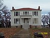 |
May 11, 2000 (#00000496) |
205 F St. 37°25′29″N 79°08′50″W / 37.424722°N 79.147222°W |
|
| 43 | Rivermont Historic District |  |
April 11, 2003 (#03000224) |
Rivermont Ave. and 200 Boston Ave. 37°26′04″N 79°09′38″W / 37.434444°N 79.160556°W |
200 Boston Avenue represents a boundary increase of May 28, 2013 |
| 44 | Rosedale | 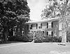 |
July 7, 1983 (#83003291) |
Old Graves Mill Rd.; also Graves Mill Rd. west of the junction with U.S. Route 501 37°22′33″N 79°13′45″W / 37.375833°N 79.229167°W |
Second location represents a boundary increase of April 10, 1992 |
| 45 | St. Paul's Church |  |
September 9, 1982 (#82004572) |
605 Clay St. 37°24′54″N 79°08′49″W / 37.415000°N 79.146944°W |
|
| 46 | Saint Paul's Vestry House |  |
February 21, 1997 (#97000157) |
308 7th St. 37°24′56″N 79°08′42″W / 37.415694°N 79.145000°W |
|
| 47 | Sandusky House |  |
July 26, 1982 (#82004571) |
757 Sandusky Dr. 37°22′49″N 79°11′47″W / 37.380278°N 79.196389°W |
|
| 48 | South River Friends Meetinghouse |  |
August 28, 1975 (#75002113) |
5810 Fort Ave. 37°22′24″N 79°11′31″W / 37.373333°N 79.191944°W |
|
| 49 | Anne Spencer House |  |
December 6, 1976 (#76002224) |
1313 Pierce St. 37°24′14″N 79°09′07″W / 37.403889°N 79.151944°W |
|
| 50 | Twelfth Street Industrial Historic District |  |
May 31, 2018 (#100002529) |
600 and 700 blocks of 12th St., 603 Grace St., and Dunbar Dr. 37°24′35″N 79°08′41″W / 37.409722°N 79.144722°W |
|
| 51 | Virginia Episcopal School |  |
October 28, 1992 (#92001392) |
400 Virginia Episcopal School Rd. 37°27′12″N 79°11′27″W / 37.453333°N 79.190833°W |
|
| 52 | Virginia University of Lynchburg |  |
February 22, 2011 (#11000035) |
2058 Garfield Ave. 37°23′43″N 79°09′06″W / 37.395278°N 79.151667°W |
|
| 53 | John Marshall Warwick House |  |
December 6, 1996 (#96001449) |
720 Court St. 37°24′53″N 79°08′41″W / 37.414861°N 79.144861°W |
|
| 54 | Western Hotel |  |
July 22, 1974 (#74002236) |
5th and Madison Sts. 37°24′57″N 79°08′56″W / 37.415833°N 79.148889°W |
|
| 55 | J. W. Wood Building | 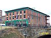 |
February 17, 1983 (#83003292) |
23-27 9th St. 37°24′58″N 79°08′26″W / 37.416111°N 79.140556°W |
Former listing edit
| [3] | Name on the Register | Image | Date listed | Date removed | Location | City or town | Description |
|---|---|---|---|---|---|---|---|
| 1 | Hayes Hall | October 26, 1979 (#79003284) | March 19, 2001 | Dewitt St. and Garfield Ave. 37°23′42″N 79°09′07″W / 37.395000°N 79.151944°W | Lynchburg | Demolished April 1988 |
See also edit
Wikimedia Commons has media related to National Register of Historic Places in Lynchburg, Virginia.
- List of National Historic Landmarks in Virginia
- National Register of Historic Places listings in Virginia
- National Register of Historic Places listings in Amherst County, Virginia
- National Register of Historic Places listings in Bedford County, Virginia
- National Register of Historic Places listings in Campbell County, Virginia
References edit
- ^ The latitude and longitude information provided in this table was derived originally from the National Register Information System, which has been found to be fairly accurate for about 99% of listings. Some locations in this table may have been corrected to current GPS standards.
- ^ National Park Service, United States Department of the Interior, "National Register of Historic Places: Weekly List Actions", retrieved April 12, 2024.
- ^ a b Numbers represent an alphabetical ordering by significant words. Various colorings, defined here, differentiate National Historic Landmarks and historic districts from other NRHP buildings, structures, sites or objects.
- ^ The eight-digit number below each date is the number assigned to each location in the National Register Information System database, which can be viewed by clicking the number.