
KNOWPIA
WELCOME TO KNOWPIA

National Register of Historic Places listings in Madison County, Ohio 
Summary
This is a list of the National Register of Historic Places listings in Madison County, Ohio.
This is intended to be a complete list of the properties and districts on the National Register of Historic Places in Madison County, Ohio, United States. The locations of National Register properties and districts for which the latitude and longitude coordinates are included below, may be seen in a Google map.[1]
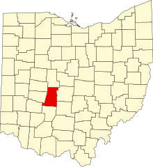
There are 11 properties and districts listed on the National Register in the county.
This National Park Service list is complete through NPS recent listings posted April 12, 2024.[2]
Current listings edit
| [3] | Name on the Register[4] | Image | Date listed[5] | Location | City or town | Description |
|---|---|---|---|---|---|---|
| 1 | Cary Village Site |  |
May 13, 1975 (#75001479) |
Amid fields around the Cary Ditch, southeast of Plain City[6] 40°04′49″N 83°14′46″W / 40.080333°N 83.246167°W | Darby Township | |
| 2 | Farmers National Bank |  |
March 9, 1995 (#95000168) |
Southwestern corner of the junction of Main and Chillicothe Sts. 40°06′27″N 83°16′03″W / 40.1075°N 83.2675°W | Plain City | |
| 3 | First United Methodist Church |  |
August 22, 1996 (#96000930) |
52 N. Main St. 39°53′14″N 83°26′59″W / 39.887222°N 83.449722°W | London | |
| 4 | London Commercial Business Historic District |  |
December 17, 1985 (#85003212) |
Roughly bounded by Adams, Superior and Clair Sts., Madison Ave., and Huron St. 39°53′05″N 83°26′49″W / 39.884722°N 83.446944°W | London | |
| 5 | Madison County Courthouse |  |
March 14, 1973 (#73001504) |
Public Sq. 39°53′12″N 83°26′57″W / 39.886667°N 83.449167°W | London | |
| 6 | Mount Sterling Historic District |  |
October 1, 1974 (#74001559) |
Both sides of London St. 39°43′12″N 83°15′54″W / 39.72°N 83.265°W | Mount Sterling | |
| 7 | Price Corners |  |
April 20, 1995 (#95000496) |
7040 U.S. Route 42 S., south of Plain City 40°02′42″N 83°17′54″W / 40.045°N 83.298333°W | Canaan Township | |
| 8 | Red Brick Tavern | 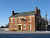 |
September 5, 1975 (#75001478) |
1700 Cumberland Rd. in Lafayette 39°56′16″N 83°24′24″W / 39.937778°N 83.406667°W | Deer Creek Township | |
| 9 | Skunk Hill Mounds |  |
July 30, 1974 (#74001560) |
On a ridge above the west bank of Little Darby Creek[7] 39°55′53″N 83°16′00″W / 39.931458°N 83.266667°W | Jefferson Township | Near West Jefferson |
| 10 | Swetland House |  |
January 11, 1983 (#83002007) |
147 E. High St. 39°53′21″N 83°26′39″W / 39.889167°N 83.444167°W | London | |
| 11 | Valentine Wilson House |  |
May 22, 1973 (#73001505) |
About 1 mile north of Summerford off Interstate 70 39°56′35″N 83°30′21″W / 39.943056°N 83.505833°W | Somerford Township | Destroyed |
See also edit
Wikimedia Commons has media related to National Register of Historic Places in Madison County, Ohio.
- List of National Historic Landmarks in Ohio
- Listings in neighboring counties: Champaign, Clark, Fayette, Franklin, Greene, Pickaway, Union
- National Register of Historic Places listings in Ohio
References edit
- ^ The latitude and longitude information provided in this table was derived originally from the National Register Information System, which has been found to be fairly accurate for about 99% of listings. Some locations in this table may have been corrected to current GPS standards.
- ^ National Park Service, United States Department of the Interior, "National Register of Historic Places: Weekly List Actions", retrieved April 12, 2024.
- ^ Numbers represent an alphabetical ordering by significant words. Various colorings, defined here, differentiate National Historic Landmarks and historic districts from other NRHP buildings, structures, sites or objects.
- ^ "National Register Information System". National Register of Historic Places. National Park Service. April 24, 2008.
- ^ The eight-digit number below each date is the number assigned to each location in the National Register Information System database, which can be viewed by clicking the number.
- ^ Location derived from Owen, Lorrie K., ed. Dictionary of Ohio Historic Places. Vol. 1. St. Clair Shores: Somerset, 1999, 646. The NRIS lists the site as "Address Restricted".
- ^ Location derived from Aument, Bruce Warren. Mortuary Variability in the Middle Big Darby Drainage of Central Ohio Between 300 B.C. and 300 A.D. Diss. Ohio State University. Columbus: Ohio State U, 1990, 85 and 113. Accessed 2009-11-10. The NRIS lists the site as "Address Restricted".