
KNOWPIA
WELCOME TO KNOWPIA

National Register of Historic Places listings in Marion County, Mississippi 
Summary
This is a list of the National Register of Historic Places listings in Marion County, Mississippi.

This is intended to be a complete list of the properties and districts on the National Register of Historic Places in Marion County, Mississippi, United States. Latitude and longitude coordinates are provided for many National Register properties and districts; these locations may be seen together in a map.[1]
There are 10 properties and districts listed on the National Register in the county.
This National Park Service list is complete through NPS recent listings posted April 12, 2024.[2]
Current listings edit
| [3] | Name on the Register | Image | Date listed[4] | Location | City or town | Description |
|---|---|---|---|---|---|---|
| 1 | Broad Street-Church Street Historic District |  |
July 8, 2008 (#08000672) |
Roughly bounded by High School St. on the west and Pine Ave. on the east along Sumrall Rd. and Broad St. 31°15′16″N 89°49′23″W / 31.254444°N 89.823056°W | Columbia | |
| 2 | Columbia Country Club | January 14, 2015 (#14001156) |
28 Golf Course Rd. 31°15′57″N 89°49′52″W / 31.2659°N 89.8312°W | Columbia | ||
| 3 | Columbia North Historic District |  |
August 20, 2009 (#09000625) |
Roughly bounded by High School and N. Main Sts. on the west and Park and Branton Aves. on the east 31°15′15″N 89°49′46″W / 31.254167°N 89.829444°W | Columbia | |
| 4 | Downtown Columbia Historic District | June 27, 1997 (#97000633) |
Roughly bounded by Broad and Church Sts. and Meak, Honey, and Beef Alleys; also 704 and 706 Honey Alley 31°15′07″N 89°50′06″W / 31.251944°N 89.835°W | Columbia | 704/706 Honey Alley represents a boundary increase of September 9, 1998 | |
| 5 | Ford House | 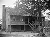 |
June 21, 1971 (#71000457) |
South of Sandy Hook on Old Columbia-Covington Rd. 31°00′44″N 89°47′11″W / 31.012222°N 89.786389°W | Sandy Hook | |
| 6 | Keys Hill Historic District | 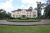 |
June 14, 1982 (#82004836) |
Broad St. 31°15′06″N 89°48′55″W / 31.251667°N 89.815278°W | Columbia | |
| 7 | Lampton-Thompson-Bourne House |  |
November 5, 1998 (#98001335) |
423 Church St. 31°15′13″N 89°49′51″W / 31.253611°N 89.830833°W | Columbia | |
| 8 | Marion County Courthouse and Jail |  |
March 3, 1995 (#95000178) |
Courthouse Square 31°15′02″N 89°50′06″W / 31.250556°N 89.835°W | Columbia | |
| 9 | Superintendent's Home at Columbia Training School |  |
July 14, 1995 (#95000787) |
1730 Mississippi Highway 44 31°15′56″N 89°48′02″W / 31.265556°N 89.800556°W | Columbia | |
| 10 | U.S. Post Office |  |
April 7, 1981 (#81000329) |
815 Main St. 31°15′15″N 89°50′08″W / 31.254167°N 89.835556°W | Columbia |
See also edit
Wikimedia Commons has media related to National Register of Historic Places in Marion County, Mississippi.
References edit
- ^ The latitude and longitude information provided in this table was derived originally from the National Register Information System, which has been found to be fairly accurate for about 99% of listings. Some locations in this table may have been corrected to current GPS standards.
- ^ National Park Service, United States Department of the Interior, "National Register of Historic Places: Weekly List Actions", retrieved April 12, 2024.
- ^ Numbers represent an alphabetical ordering by significant words. Various colorings, defined here, differentiate National Historic Landmarks and historic districts from other NRHP buildings, structures, sites or objects.
- ^ The eight-digit number below each date is the number assigned to each location in the National Register Information System database, which can be viewed by clicking the number.